
Llangollen Canal facts for kids
Quick facts for kids Llangollen Canal |
|
|---|---|

Llangollen canal: The final narrows before Llangollen
|
|
| Specifications | |
| Maximum boat length | 70 ft 0 in (21.34 m) |
| Maximum boat beam | 6 ft 10 in (2.08 m) (Fenders must be raised in locks – warning shown at Hurleston) |
| Locks | 21 |
| Maximum height above sea level | 230 ft (70 m) |
| Status | Open |
| Navigation authority | Canal & River Trust |
| Geography | |
| Start point | Hurleston Junction (Junction with Shropshire Union Canal) |
| End point | Llangollen (Unnavigable canal continues to Horseshoe Falls) |
| Branch(es) | Montgomery Canal, Prees Branch, Ellesmere Arm, Whitchurch Arm, Trevor Basin |
The Llangollen Canal (Welsh: Camlas Llangollen) is a cool waterway that crosses the border between England and Wales. It connects Llangollen in north Wales with Hurleston in south Cheshire. The canal also passes through the town of Ellesmere, Shropshire.
This canal wasn't always called the Llangollen Canal. That name was made up in the 1980s. Before that, it was part of the old Ellesmere Canal and a special water supply channel called the Llangollen navigable feeder. Both of these became part of the Shropshire Union Canals in 1846.
The Ellesmere Canal was first planned by people who owned mines and factories near Ruabon. They wanted to connect their businesses to the River Mersey and the River Dee. Two separate parts of the canal were built. The northern part went from Ellesmere Port to Chester, opening in 1795. The southern part started at Frankton and went south to Llanymynech. Another section was built west towards Trevor.
Building the canal meant crossing two rivers: the Afon Ceiriog and the River Dee. Engineers built huge bridges called aqueducts to carry the canal's water across. The Chirk Aqueduct opened in 1801, crossing the Ceiriog. The canal then went through Chirk Tunnel and reached the Pontcysyllte Aqueduct in 1802, which was finished in 1805.
Instead of connecting the two parts directly, a new route was built from Frankton to Hurleston Junction. This route opened in 1805. To make sure the canal had enough water, a special channel was built to Llantisilio. Here, the Horseshoe Falls weir was built on the River Dee to feed water into the canal.
The Llangollen Canal was very busy until the end of the First World War. After that, fewer boats used it. In 1944, the owners, the London, Midland and Scottish Railway, officially stopped using it for boats. However, the canal was kept open because it supplied water to other canals and later to a water company.
In the 1940s, people like Tom Rolt started exploring the canal for fun. Even though it was officially closed, more and more boats began to use it. People campaigned to reopen it for leisure. Finally, in 1968, a new law made the canal a "cruiseway," meaning it was officially open for pleasure boats.
As more people enjoyed boating, the canal was renamed "The Llangollen Canal" in the 1980s. It quickly became one of the most popular places for canal holidays. In 2009, a special 11-mile (18 km) section of the canal, including the amazing Pontcysyllte and Chirk aqueducts, was named a World Heritage Site by UNESCO. This means it's a very important place for everyone to protect and enjoy.
Contents
Building the Llangollen Canal

The idea for the Ellesmere Canal started in 1791. A group of business owners wanted to connect their coal and iron mines near Ruabon to the River Mersey and the River Severn. Their plan was to link up with the Chester Canal and then reach the Mersey at Ellesmere Port. They also wanted a southern route towards Shrewsbury.
There were other ideas too, but the first group's plans moved forward. Work began, but over time, the plans changed a lot. Engineers like William Jessop and Thomas Telford were hired to help design the canal. In 1793, a special law was passed by Parliament to allow the canal to be built.
Work on the northern part of the canal began in 1793. Boats started using it in 1795, even before it was fully finished. Coal was carried to Chester by 1797. The company also wanted to transport limestone from Llanymynech. So, they started building the canal south from Frankton in 1794. This section opened in 1796, connecting with the Montgomeryshire Canal.
Crossing Rivers with Aqueducts
Building the canal from Frankton towards Trevor was hard because of two rivers: the Afon Ceiriog and the River Dee. They needed tall aqueducts to carry the canal over these valleys.
In 1795, Jessop suggested building the Pontcysyllte Aqueduct 125 feet (38 m) above the River Dee. He proposed using an iron trough to hold the water, which would save money. He also suggested a similar iron trough for the Chirk Aqueduct. This idea helped convince landowners to allow the aqueducts to be built. The first stone for Pontcysyllte was laid in July 1795.
Work on the Chirk Aqueduct began in 1796. It's 600 feet (180 m) long with ten arches, carrying the canal 70 feet (21 m) above the Afon Ceiriog. This aqueduct has a cast-iron bottom but stone sides. The 8-mile (13 km) section from Chirk to Frankton, which included six locks, was finished in 1801. The canal then went through Chirk and Whitehouses tunnels, reaching Pontcysyllte in 1802.
Connecting the Canal Sections
In 1795, Telford looked at how to connect the southern and northern parts of the canal. His plans were approved in 1796. They involved a difficult route from Trevor to Chester, with a branch to serve the Brymbo ironworks. However, most of this ambitious plan was never built.
By 1800, Jessop decided that the route between Trevor and Chester should be given up. This was because coal was available in Chester from other places.
The Chester Canal, which wasn't doing well financially, hoped to connect with the Ellesmere Canal. When this didn't happen, they even cut off the water supply to the northern section of the Ellesmere Canal! But they agreed to restore the water when a new line from Frankton Junction to Whitchurch was planned.
Work on this new line started in 1797. It was tough because it had to cross Whixall Moss. A 261-foot (80 m) tunnel was also needed near Ellesmere. By 1804, the main line reached Tilstock Park.
In 1802, another agreement was made for a route from Tilstock Park to Hurleston Junction. This section was finished on March 25, 1805. To keep the whole canal system full of water, a law was passed in 1804 to build a navigable feeder from Pontcysyllte to Llangollen and then to Llantisilio. The Horseshoe Falls weir was built on the River Dee to supply this water. When it opened in 1808, the canal had plenty of water.
In 1813, the Ellesmere Canal Company and the Chester Canal Company joined together. Later, in 1845, this new company absorbed several other canals, including the Montgomeryshire and Shrewsbury Canals. The name changed to the Shropshire Union Railways and Canal Company in 1846. This company was later taken over by the London and North Western Railway and then by the London, Midland and Scottish Railway in 1922.
Decline and Restoration
After the railway company took over, the canals weren't always well maintained. They started to get blocked with silt, making it hard for boats to carry full loads. Traffic slowly stopped. By 1937, boats no longer went beyond Frankton to Llangollen.
In 1944, the railway company got permission to close many canals, including parts of the Shropshire Union system. However, the section from Hurleston to Llangollen was saved. Why? Because it was the main source of water for the rest of the canal system.
In 1945, a part of the canal near Llangollen broke open because it hadn't been maintained well. This caused a train crash nearby. Even though the canal was officially closed, it was repaired quickly so that water could keep flowing to Hurleston. The canal's role as a water supply channel became even more important, and a water board agreed to help maintain it.
Bringing the Canal Back to Life
Even though there wasn't much boat traffic after World War I, the canal always had water because it supplied other canals. After World War II, people became interested in using canals for fun. Tom Rolt, a famous canal explorer, tried to boat on the Llangollen Canal in 1947. The canal was in bad shape, with low water and lots of weeds, but he eventually reached Ellesmere.
Later, in 1949, Rolt and his wife successfully reached Pontcysyllte. Other canal fans also started using the waterway. In 1952, the Inland Waterways Association even held a gathering of boats at Llangollen.
By 1954, the Llangollen Canal was in a strange situation. It was officially closed for boats, but it was kept open to sell water. People started a campaign to reopen it for boating. Many groups supported this idea.
At first, government reports in 1955 and 1958 said the Llangollen Canal didn't have enough business potential to stay open for boats. But these reports also hinted that canals could be kept for fun and recreation.
Things started to change. In 1966, a report noted the growing number of people using the Llangollen Canal for leisure. Official attitudes shifted, and the Transport Act of 1968 put canals under the control of the British Waterways Board. Their job was to maintain and develop canals for users. The entire section from Hurleston Junction to Llantisilio was listed as a "cruising waterway." This meant its future was safe!
As more people used it for holidays, the canal became known as the Llangollen Canal. It's now one of the most popular canals for holidaymakers in Britain. The name is used for the whole route, even though it was never called that when it was a working canal.
Famous Features of the Canal
The canal has some amazing structures:
- The Pontcysyllte Aqueduct, built by Thomas Telford, is a true wonder. Opened in 1805, it's over 300 metres (980 ft) long and 38 metres (125 ft) high above the valley floor. It has 19 stone arches.
- Another aqueduct carries the canal over the River Ceiriog at Chirk.
- There are also tunnels nearby at Whitehouses, Chirk, and Ellesmere.
The canal also runs along the edge of the Fenn's, Whixall and Bettisfield Mosses National Nature Reserve. This reserve is a very important area of peat bog. In 2009, the 11-mile (18 km) section of the canal that includes the Chirk and Pontcysyllte Aqueducts was declared a World Heritage Site by UNESCO.
-
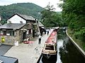
Llangollen canal wharf.
-
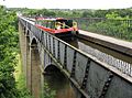
A narrowboat crosses the Pontcysyllte Aqueduct.


Exploring the Canal Route
Hurleston to Frankton Junction
The Llangollen Canal starts at Hurleston Junction, where it rises from the Shropshire Union Canal through four locks. These locks lift boats by about 34 feet 3 inches (10.44 m). Some of these locks use iron gates, which were an early invention for canals.
Next to the locks is Hurleston Reservoir. This large reservoir holds 85 million imperial gallons (390 Ml) of water. It gets its water from Horseshoe Falls at Llantisilio, flowing down the canal. This water is used for drinking and to supply the main Shropshire Union Canal.
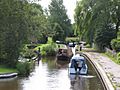
Further along, you'll find Swanley Bridge Marina, which can hold over 300 boats. It's surrounded by farmland and a small wood with nature trails.
The canal continues through more locks, including the Swanley and Baddiley locks, which raise the canal's level even more. You can see old farmhouses and a historic church along this section.

After Wrenbury Hall, the canal turns west. Here, you'll find three lift bridges in Wrenbury village. One of them, Wrenbury Church lift bridge, is a special old timber bridge. Wrenbury lift bridge, No. 20, is automated. You use a special key to operate it, closing barriers for road traffic.
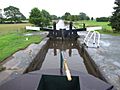
At Grindley Brook, the canal goes through three locks and a unique three-chamber staircase lock. During summer, a lock keeper is often there to help boats. These six locks raise the canal by nearly 38 feet 11 inches (11.86 m).
After about a mile, there's a lift bridge before the entrance to the Whitchurch Arm. This branch used to serve the town of Whitchurch. Part of it is now open for moorings. The Whitchurch Waterway Trust worked to reopen this section in 1993, bringing boats back to the town.
Between bridges 42 and 47, the canal passes through the Fenn's, Whixall and Bettisfield Mosses National Nature Reserve. This area has some of the largest raised peat bogs in the UK. It's a very important nature reserve.
Building the canal through Whixall Moss was a big challenge. Engineers built the canal on a special raft across the peat. They had a team of workers, known as the Whixall Moss Gang, who continuously added clay to the banks to stop the canal from sinking. This work continued for many years!
Near bridge 46 is Whixall Moss Junction, which leads to the Prees Branch. Sometimes, badgers have caused problems by burrowing into the canal banks, leading to small breaches.
As the canal gets closer to Ellesmere, it passes several beautiful lakes called meres. Cole Mere and Blake Mere are very close to the canal. The canal is lined with oak trees, many planted long ago to provide timber for boats.
At the end of Blake Mere is the short Ellesmere Tunnel. Beyond that is the town of Ellesmere. A short branch goes into the town, where you can see an old warehouse. The Canal and River Trust has a maintenance depot here, with historic buildings that are very well preserved.
The canal also goes through Burland, Quoisley Bridge, and Bettisfield.
Prees Branch
The Prees Arm of the canal was meant to reach Prees, but only about 3.75 miles (6.04 km) were built. Today, only about 0.75 miles (1.21 km) is open for boats, leading to a marina. Beyond that, another 0.62 miles (1 km) is partially watered and is now the Prees Branch Canal Nature Reserve.
Near the junction, there's an old toll-keeper's cottage from when the canal was built. Allman's Bridge is an old wooden lift bridge that was converted to hydraulic power in 2010. Starks Bridge is another special wooden lift bridge, which is also a scheduled ancient monument.
At the end of the navigable part is Whixall Marina. This marina was built where clay used to be dug out for the canal. It was updated in 2017-2018 with new facilities. The marina is also close to Whixall Moss, which is popular with walkers.
-
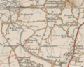
Old map showing the complete branch to Quina Brook
-
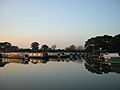
Evening over Whixall Marina


Frankton Junction to Trevor Basin
At Frankton Junction, the Montgomery Canal heads south. The Llangollen Canal continues, and its bridges have a special numbering system to avoid confusion with the Montgomery Canal.
The Llangollen Canal passes through places like Hindford, Saint Martin's, Chirk, and Froncysyllte. This section includes the famous Chirk Aqueduct, the Chirk Tunnel, and the amazing Pontcysyllte Aqueduct.
-
New Marton Bottom Lock
-
New Marton Top Lock


Trevor Basin to Horseshoe Falls
This last section of the canal was built to supply water. It's quite shallow and narrow. In some parts near Llangollen, boats can't pass each other, so you need to check ahead for oncoming boats. Boats with a deep bottom (more than 21 inches (53 cm)) might find it hard to navigate here.
Over the years, parts of this section have had problems with water leaks. In the 1980s, British Waterways fixed this by lining parts of the canal with concrete and adding drainage pipes.
Beyond the entrance to Llangollen Marina, powered boats are not allowed. This final part is used only by horse-drawn trip boats. These boats continue a long tradition that started in 1884, offering rides to visitors. The towpath is in good condition, so walkers can easily reach the weir at Horseshoe Falls.
In 2005, a marina was built near Llangollen Wharf to provide more places for boats to moor. There are also visitor moorings with electricity and water. Mooring in Llangollen is limited to 48 hours, and there's a charge for both the marina and visitor moorings.
