
Pontcysyllte Aqueduct facts for kids
Quick facts for kids Pontcysyllte AqueductTraphont Ddŵr Pontcysyllte |
|
|---|---|
 |
|
| Coordinates | 52°58′14″N 03°05′16″W / 52.97056°N 3.08778°W |
| OS grid reference | |
| Carries | Llangollen Canal |
| Crosses | River Dee |
| Locale | Froncysyllte, Wrexham, Wales |
| Maintained by | Glandŵr Cymru – the Canal & River Trust |
| Heritage status | Grade I listed |
| Characteristics | |
| Trough construction | Cast iron |
| Pier construction | Stone |
| Total length | 336 yd (307 m) |
| Width | 12 ft (3.7 m) |
| Height | 126 ft (38 m) |
| Water depth | 5 ft 3 in (1.60 m) |
| Traversable? | Yes |
| Towpaths | East side |
| Number of spans | 18 |
| Piers in water | 4 |
| History | |
| Designer | Thomas Telford |
| Construction begin | 25 July 1795 |
| Opened | 26 November 1805 |
| UNESCO World Heritage Site | |
| Official name | Pontcysyllte Aqueduct and Canal |
| Criteria | Cultural: i, ii, iv |
| Inscription | 2009 (33rd Session) |
| Area | 105 ha |
| Buffer zone | 4,145 ha |
The Pontcysyllte Aqueduct is an amazing bridge that carries a canal, called the Llangollen Canal, high above the River Dee in northeast Wales. It's like a watery road in the sky!
This incredible structure has 18 arches and is made from stone and cast iron. It was built for narrowboats and finished in 1805. It took ten years to design and build.
The aqueduct is about 3.7 meters (12 feet) wide. It is the longest aqueduct in Great Britain. It is also the highest canal aqueduct in the world! A path for walking, called a towpath, runs along one side of the water.
The Pontcysyllte Aqueduct was meant to be a key part of a bigger plan. This plan was for an industrial waterway called the Ellesmere Canal. This canal would have connected the River Severn in Shrewsbury to the Port of Liverpool on the River Mersey. The aqueduct was built to cross a valley where there were lots of valuable minerals.
Not all parts of the canal were finished because there wasn't enough money. Most of the big construction stopped after the aqueduct was completed in 1805. Today, the aqueduct is a very important historical building. It is also part of a UNESCO World Heritage Site.
Contents
What's in a Name? Pontcysyllte Explained
The name Pontcysyllte comes from the Welsh words for "Cysyllte Bridge." Cysyllte was the name of a local area in the old parish of Llangollen. The southern end of the bridge is in this area.
Some people think the name means "bridge of the junction" or "bridge that links." This is because it sounds a bit like the Welsh word for "connections." However, this idea is not correct. The name simply refers to the place it was built.
Building a Watery Wonder: History of the Aqueduct

The Pontcysyllte Aqueduct was designed by two clever engineers, Thomas Telford and William Jessop. They chose a spot near an old road bridge. At first, the plan was to build many locks to lower boats down to an embankment. This embankment would then carry the canal over the River Dee.
But Telford had a better idea! He suggested building one long aqueduct to carry the water straight across the valley. This would allow boats to travel without stopping. Telford was confident because he had already built a similar, but smaller, cast-iron aqueduct. This was the Longdon-on-Tern Aqueduct.
The Pontcysyllte Aqueduct was one of Telford's first big engineering projects. Jessop, who had more experience with canals, oversaw the work. The iron parts were made by William Hazledine in his factories. The whole project took about ten years to plan and build. It cost around £47,000, which was a huge amount of money back then.
The aqueduct officially opened on 26 November 1805. A special plaque was put up to celebrate. It talked about how people from different areas worked together. They wanted to connect England and North Wales using canals. This would help farming and trade.
The bridge is 307 meters (336 yards) long. It is 3.7 meters (12 feet) wide and 1.6 meters (5 feet 3 inches) deep. It has a trough made of cast iron that holds the water. This trough is held up 38 meters (126 feet) above the river by iron arches. These arches rest on 18 hollow stone pillars. Each of the 18 sections is 16 meters (53 feet) wide.
After the aqueduct was finished, the canal was supposed to continue further. However, this part of the plan was cancelled. So, Trevor Basin, just past the aqueduct, became the end of the canal. In 1808, a channel was built to bring water from the River Dee near Llangollen. To make sure there was always enough water, Telford built an artificial waterfall called the Horseshoe Falls.
Later, other smaller canals and railways were built to help local industries. In 1846, the aqueduct became part of the Shropshire Union Railways and Canal Company. This company thought about turning canals into railways. But they decided to keep the canal open because it was still useful.

Commercial boats used the canal less after a part of it broke in 1936. By 1939, boats had stopped crossing the aqueduct to Llangollen. The canal was officially closed to boats in 1944. In 1945, due to not enough care, the canal banks broke near Llangollen. This caused a train crash, which was very sad.
Even though it was closed to boats, the aqueduct was saved. It was still needed to supply water to other parts of the Shropshire Union Canal. It also supplied drinking water to a reservoir. In 1955, a water board agreed to look after the canal, which secured its future.
In the late 1900s, more people started using the canal for fun. It was renamed the Llangollen Canal. It is now one of the most popular canals for holidays in Britain. People love its aqueducts and beautiful scenery. The Canal & River Trust (known as Glandŵr Cymru in Wales) now looks after the Pontcysyllte Aqueduct. You might even spot otters in the area!
How the Aqueduct was Built and is Maintained

The builders used a special mortar mix. It contained lime, water, and even ox blood! Blood was used in old buildings to help make the mortar stronger. It helped it last longer in freezing and thawing weather.
The iron parts for the water trough were made nearby. They were produced at the Plas Kynaston Foundry. The trough itself was made from cast iron plates. These plates were bolted together. The joints were sealed with Welsh flannel and a mix of white lead and iron particles.
After 25 years, the white lead was replaced with tar. The iron plates are shaped like the stones in a traditional arch. This was a decorative choice, making the iron look like stone.
Special sandstone was found nearby in Cefn Mawr. This stone was used to create many of the shapes needed for the aqueduct. You can still see signs of where the stone was worked today.
The aqueduct has four supporting arches for each section. These are made of cast-iron ribs. Using cast iron in this way made it very strong. It also made the aqueduct look very solid.
The bottom of the canal trough is made of cast plates laid across. The trough is not directly attached to the arches. Instead, special parts on the plates fit over the arches to stop them from moving. The aqueduct was filled with water for six months to make sure it didn't leak.
A cool fact about canal aqueducts is that the weight on them stays almost the same. This is because of Archimedes' principle. When a boat enters the aqueduct, it pushes out an equal weight of water. So, the total weight on the bridge doesn't change much.
The towpath is built above the water level. It rests on cast-iron pillars inside the trough. This design allows water to flow easily under the towpath and around boats. This helps boats move freely. The original wooden towpath was replaced with an iron one in 1831.
Walkers and the horses that once pulled boats are kept safe by railings. But the sides of the trough only rise about 15 centimeters (6 inches) above the water. This is less than the side of an empty narrowboat. So, from a boat, it can feel like you are right on the edge of a huge drop!
Every five years, the ends of the aqueduct are closed. A plug in one of the highest sections is opened to drain the canal water into the River Dee. This allows workers to inspect and maintain the trough. The aqueduct was closed for maintenance in mid-2024. It will close again from January to mid-March 2025 for more work.
A World Heritage Site
The Pontcysyllte Aqueduct and the land around it were first suggested for UNESCO World Heritage Site status in 1999. In 2005, its 200th anniversary, it was put forward as a strong candidate. In 2006, it was announced that a larger area would be nominated. This area included a section of the canal from the aqueduct to Horseshoe Falls. It also included the older Chirk Aqueduct.
Experts from UNESCO visited in October 2008. They checked how the site was managed and its historical importance. On 27 June 2009, the aqueduct was officially added to the World Heritage List. This means it is considered very important for everyone in the world to protect.
Images for kids
-
A view of the Dee Valley from the aqueduct
-
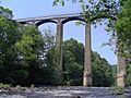
From the river and valley
-
The canal being drained for inspection and maintenance (2009)
-

Pontcysyllte Aqueduct in Winter
-
-
Aqueduct viewed with Pont Cysyllte bridge and Cefn Mawr Viaduct
-

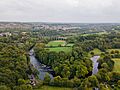
Aerial view
-
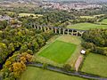
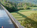
Aerial view showing football ground and Cefn Mawr
-
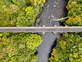
Aerial view
-
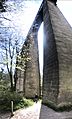
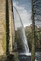
Pontcysyllte Aqueduct viewed from below at its northern end


See also
 In Spanish: Acueducto de Pontcysyllte para niños
- Canals of the United Kingdom
- List of canal aqueducts in Great Britain
- List of bridges in Wales
