
Church Stretton facts for kids
Quick facts for kids Church Stretton
|
|
|---|---|
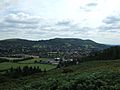
 Church Stretton viewed from the Ragleth |
|

Church Stretton
|
|
| Population | 4,671 |
| OS grid reference | SO453937 |
| • London | 158 miles (254 km) |
| Civil parish |
|
| Unitary authority |
|
| Ceremonial county | |
| Region | |
| Country | England |
| Sovereign state | United Kingdom |
| Post town | CHURCH STRETTON |
| Postcode district | SY6 |
| Dialling code | 01694 |
| Police | West Mercia |
| Fire | Shropshire |
| Ambulance | West Midlands |
| EU Parliament | West Midlands |
| UK Parliament |
|
| Website | churchstretton.co.uk |
Church Stretton is a lively market town in Shropshire, England. It's about 13 kilometres (8 miles) south of Shrewsbury and 15 kilometres (9 miles) north of Ludlow. In 2011, about 4,671 people lived here.
Long ago, in the late Victorian and Edwardian times, people called the town "Little Switzerland". This was because of its beautiful hills and valleys, which looked a bit like the famous country. It even became a popular place for people to visit for their health.
The rocks around Church Stretton are some of the oldest in England. There's also a big crack in the Earth's crust, called a fault, named after the town. Church Stretton is nestled in the Shropshire Hills, a special area known for its amazing natural beauty.
Contents
History of Church Stretton

People have lived in the Stretton Gap, a valley between hills, for thousands of years. An Iron Age hillfort, an old fort on a hill, can still be seen on Caer Caradoc overlooking the town.
The name "Stretton" comes from old English words. Stræt means "Roman road" and tun means "settlement". A Roman road called Watling Street runs through the Stretton Gap. However, the early settlements were built a little way from the road for safety. Today, the modern A49 road follows a similar path to the old Roman road.
The areas of Little Stretton, Church Stretton, and All Stretton were once part of a larger area called the manor of Stretton. A manor was a large estate ruled by a lord. In 1086, a survey called the Domesday Book showed 35 homes and a mill in this manor. Church Stretton grew to be the biggest settlement. It had the main church and a market.
Market Town Life
King John first allowed Church Stretton to hold a market in 1214. It was held every Wednesday. Later, the market day changed to Tuesdays, and then in 1337, King Edward III said it should be on Thursdays. The market is still held every Thursday in the town square on High Street. This has been the market place since the 1200s.
In 1593, a big fire destroyed much of the town. Many of the buildings you see today with wooden frames were built after this fire. The High Street was once much wider. Over time, buildings were put up, making it narrower.
Carding Mill Valley's Past

Church Stretton was once known for making textiles, especially cloth from local wool. A key place for this was Carding Mill Valley. A carding mill was built there in the 1700s. "Carding" was the first step in making cloth. Children would use special tools with metal spikes to untangle wool fibres. After carding, the wool was spun into yarn and then woven into fabric.
The carding mill closed and was taken down in the early 1900s. However, the valley kept its name, "Carding Mill Valley." Today, it's a popular place for visitors and walkers. You can follow the valley up to the beautiful Lightspout waterfall. The National Trust owns the valley and has a visitor centre there.
The car park in the valley was once an outdoor swimming pool! You can still see a sign showing the water depth.
Church Stretton in the Past

The nickname "Little Switzerland" came about because of the town's lovely surroundings. Many houses are built into the hillsides, adding to this look.
The Church Stretton railway station first opened in 1852. It was part of the new Shrewsbury and Hereford Railway. The original station building is still there, but it's not used for trains anymore. In 1914, the station moved to its current spot.
A local property developer, Ralph Beaumont Benson, helped name some of the town's streets. These include Easthope Road, Essex Road (named after his wife), Beaumont Road, and Lutwyche Road. These streets were part of the town's growth in the early 1900s.
The Longmynd Hotel
The Longmynd Hotel opened in 1901. It was first called "The Hydropathic Hotel" because the town was a popular spa resort. Today, it's still a hotel and a place for weddings and conferences. In 2012, it was sold to a company called 'HF Holidays'. It is now a hostel used only by HF members.
Mid-1900s Changes
During and after World War II, from 1940 to 1946, a charity called St Dunstan's (now Blind Veterans UK) was based in Church Stretton. It helped soldiers who had lost their sight. The charity moved from Sussex because Church Stretton was considered a safe place. About 700 people were trained here. A street called St Dunstan's Close is named after the charity.
Recent Times

A small market hall on High Street was taken down in 1963. This area became the town square, which is still used for markets. The Silvester Horne Institute is now the town's main meeting place. It's used for clubs, public meetings, and shows.
Volunteers have made Church Stretton a "Town of Flags." They've bought over 120 flags from England, the UK, and other countries. These flags are flown in the town centre on special days throughout the year.
Most of the town centre is part of the Church Stretton Conservation Area. This means that buildings and areas are protected to keep their historic look. St Laurence's Church is a very important historic building.
How Church Stretton's Population Grew
The number of people living in Church Stretton has changed over time. Here's how the population of the parish (including nearby villages) has grown:
|
|
|

The population stayed about the same between 1841 and 1901. Then, it grew a lot in the early 1900s. This was when the town became a popular place to live. Another big growth happened between 1931 and 1951. Since then, it has grown steadily.
Geography of Church Stretton


Church Stretton is about 13 kilometres (8 miles) south of Shrewsbury, Shropshire's main town. The town is surrounded by hills. To the west is the huge Long Mynd mountain range. To the east are Caer Caradoc and other hills like Hazler and Ragleth.
The town sits in a low point between hills, like a saddle. The railway station is about 187 metres (614 feet) above sea level. The High Street is a bit higher, at 194 metres (636 feet). Because of this "saddle" shape, water flows away from the town in two directions. North towards the River Severn and south towards the River Teme.
Parts of the Town
The oldest part of Church Stretton is around the church and along High Street. When the railway station was built in 1852, the town started to grow towards it, along what is now Sandford Avenue. Today, High Street and Sandford Avenue are the two main shopping streets.
Cunnery is a hillside area west of the town centre. It's home to the Long Mynd Hotel. World's End is where Ludlow Road curves around the hill south of the hotel. North of the town centre is Ashbrook. Here, Carding Mill Valley meets the town. A stream, also called the Ashbrook, runs through two main recreation fields.
Other public green spaces include Rectory Wood & Field and the town's park. The park has tennis courts and a bowling green.
On the east side of the A49 road are three areas: Battle Field, Snatchfield, and Hazler. Hazler Hill has a transmitter for local radio. Battle Field is named after a legend. People say Caer Caradoc was where the British leader Caractacus made his last stand against the Romans.
All Stretton and Little Stretton
The villages of All Stretton and Little Stretton are separate from Church Stretton. The B5477 road connects all three. All Stretton is about 1.0 kilometre (0.6 miles) north of Church Stretton. Little Stretton is about 1.3 kilometres (0.8 miles) south. Even though there are some buildings along the road, the villages are not fully joined. The three settlements are sometimes called "the Strettons."
 |
Picklescott, Pulverbatch, Minsterley | Shrewsbury All Stretton, Dorrington |
Telford Cardington, Acton Burnell, Much Wenlock |
|
| Long Mynd, Wentnor, Montgomery | Hope Bowdler, Rushbury, Bridgnorth | |||
| Cwm Head, Bishop's Castle, Clun | Little Stretton, Craven Arms, Ludlow | Ticklerton, Munslow, Clee Hills |
How Church Stretton is Governed

Church Stretton is part of a civil parish. This area is managed by a parish council called Church Stretton Town council. This council also looks after All Stretton, Little Stretton, and other small areas nearby. The parish is divided into four sections, each with its own councillors.
The Town Council has its offices at 60 High Street. They hold their meetings at the Silvester Horne Institute, also on High Street.
Town Mayors
The mayor of a town council is called a Town Mayor. The councillors choose one of their members to be the chairman and Town Mayor each May. Church Stretton's council became a town council in 2002, and the title of Town Mayor was first used in 2004.
| Term | Chairman and Town Mayor | Ward | Note | ||||
|---|---|---|---|---|---|---|---|
| 2003–2006 | Leslie McIntyre | All Stretton | The first Town Mayor, from 2004 | ||||
| 2006–2007 | Beryl Smith | Church Stretton South | |||||
| 2007–2012 | Bob Welch | Church Stretton North | |||||
| 2012–2013 | Tom Beaumont | Church Stretton North | |||||
| 2013–2015 | Michael Braid | Church Stretton North | 2015– | Michael Walker | Little Stretton |
Member of Parliament
For national matters, Church Stretton is in the South Shropshire constituency. The person who represents this area in the UK Parliament is called a Member of Parliament, or "MP." The current MP is Stuart Anderson, from the Conservative party. He was elected in 2024.
Geology of Church Stretton
The rocks and ground around Church Stretton are very interesting. The area sits right on the Church Stretton Fault. This is a huge crack in the Earth's crust. The rocks here are some of the oldest in England, formed over 560 million years ago.
In 1990, a nearby fault caused an earthquake measuring 5.1 on the Richter scale. This was known as the Bishop's Castle earthquake. The area is also important in the history of geology. A place called Comley Quarry, near the town, was the first place in the British Isles where trilobites were found. Trilobites are ancient sea creatures.
Transport in Church Stretton

Roads
The A49 is a main road that goes through the Stretton Gap. It connects Shrewsbury in the north with Ludlow and Hereford in the south. The B5477 road goes through All Stretton, Little Stretton, and the centre of Church Stretton. The B4371 road starts in the town centre and heads east towards Much Wenlock. In town, the B4371 is known as Sandford Avenue.
The Burway
The Burway is a very old road that climbs from the town up to the flat top of the Long Mynd. It's the highest public road in Shropshire, reaching about 492 metres (1,614 feet) above sea level. It goes close to the highest point of the Long Mynd, called Pole Bank. The Burway allows cars to cross the Long Mynd to other villages.
In winter, heavy snow can make the Burway impossible to use. Gates have been put up to stop drivers from using the road in snowy conditions. The part of the road within the town is called Burway Road.
Railway

The Welsh Marches Line railway track runs through the town. Church Stretton's station is near Sandford Avenue. The railway was built in 1852. Trains on the Heart of Wales Line also stop at the station.
Today, you can catch direct trains to many places. These include Shrewsbury, Chester, Manchester, Ludlow, and Cardiff. Many people use this station for a town of its size.
Buses

The town has a bus route, the 435, which runs between Shrewsbury and Ludlow. It operates Monday to Saturday. This bus connects Church Stretton with nearby villages.
On weekends and holidays during spring and summer, there are special "Shropshire Hills Shuttles" buses. One route goes over the Long Mynd to other villages. Another route, called the Wenlock Wanderer, goes to Much Wenlock. All bus services stop at Beaumont Road in the town centre. The Shuttles also stop at Carding Mill Valley.
Cycling
A regional Cycle Route 32/33 goes through Church Stretton. This route avoids the busy A49 road. The area is also popular for mountain biking. There are many paths and country lanes in the hilly countryside.
Economy of Church Stretton

Church Stretton has a mineral water bottling plant on Shrewsbury Road. It has been running since 1883. It supplies mineral water to Princes. This plant is an important local employer. There are also polymer laboratories owned by Agilent Technologies.
Tourism is a growing industry in the area. The town also attracts local shoppers. A recent survey showed that Church Stretton has about 50 shops. Most of these are independent, meaning they are not part of big chains. You can find butchers, outdoor shops, a baker, and supermarkets.
There is a large antiques market in an old building on Sandford Avenue. The town has four pubs and many cafes and small restaurants. In 2011, Church Stretton became a "Fairtrade Town." This means many businesses sell fair trade products.
The town is still known as a spa town and a nice place to live, especially for retirement. House prices here are higher than the average for the county.
Culture and Sport in Church Stretton

The town has inspired writers. The novelist Henry Kingsley wrote "Stretton" about this area. Oliver Sandys' book, "Quaint Place," is set in Church Stretton. The Lone Pine Club children's books by Malcolm Saville also take place here.
Church Stretton is a big centre for archery. There's also a gliding airfield on the Long Mynd, owned by the Midland Gliding Club. People also enjoy paragliding and hang gliding from the Long Mynd. In 2009, Church Stretton became a "Walkers Are Welcome" town. Its many well-kept footpaths make it a great place for walking.
In the town, you can find sports facilities near the schools. These include a swimming pool and a sports and leisure centre. The town council also provides facilities at the town park. These include a BMX track, crazy golf, tennis courts, a bowling green, and a croquet pitch.
Summer Festival
Every June, Church Stretton holds a "Summerfest." Volunteers and local businesses organize this event. The town centre streets are closed to traffic. There are stalls, entertainment, and activities. You can see classic cars and steam engines. In the evening, there's a concert in Rectory Field.
Churches in Town
The town has four churches. In the centre is the historic parish church of St Laurence. It's the town's Church of England church. It has a small graveyard around it. St Laurence's Church has a very old stone carving from its Anglo-Saxon past.
The other three churches are:
- The United Reformed Church on Ludlow Road.
- A Roman Catholic church dedicated to St Milburga on Sandford Avenue.
- A Methodist church on Crossways.
Golf Course

Church Stretton has an 18-hole golf course about a kilometre from the town centre. It's called the Church Stretton Golf Club. It's one of the highest golf courses in the country. It's located on the side of the Long Mynd hills. The clubhouse is about 230 metres (755 feet) above sea level. The course climbs up to about 375 metres (1,230 feet).
The town's golf course is the oldest 18-hole course in Shropshire. It started in 1898. Famous golfers like James Braid, Harry Vardon, and J. H. Taylor played here many times.
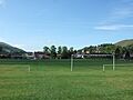
Football

Church Stretton Town F.C. is a football team. They play in the West Midlands Regional League Division 2. Their home games are played at Russell's Meadow, near the town centre. The team's colours are black and white stripes.
Russell's Meadow has been a football field since the 1930s. There's also a separate football club for players under 16, called the Church Stretton Magpies.
Cricket
In the summer, Russell's Meadow is used for cricket. The Church Stretton Cricket Club has teams that play in the Shropshire County Cricket League. They also play friendly matches on Sundays.
Media
Local news and TV shows for Church Stretton come from BBC West Midlands and ITV Central. You can listen to local radio stations like BBC Radio Shropshire (90.0 FM) and Hits Radio Black Country & Shropshire (103.1 FM). The local newspaper is the Shropshire Star.
Public Services
Education
Church Stretton has two state-funded schools. Church Stretton School is a secondary school with about 750 students. There's also a primary school called "St Lawrence" with about 210 students. The two schools are next to each other. The town also has a public library on Church Street. It's in old Victorian school buildings. It also serves as the town's tourist information centre.
Emergency Services

At the junction of Sandford Avenue and Essex Road, you'll find a police station (West Mercia Police) and a fire station (Shropshire Fire and Rescue Service). The police station is open Monday to Friday. The fire station has two fire engines and is staffed by retained firefighters, who are on call.
Notable People from Church Stretton

Many interesting people have connections to Church Stretton:
- Sir John Thynne (born around 1515 in Church Stretton) was a Member of Parliament. He built the famous Longleat House.
- Roger Maynwaring (born around 1589/90 in Church Stretton) became a Bishop.
- John Mainwaring (1724-1807) was a theologian and the first person to write about the composer Handel. He was the Rector of Church Stretton.
- Hesba Stretton, a well-known author, often visited Church Stretton. Her pen name, Stretton, came from the nearby village of All Stretton.
- Artist Sir Frederic Leighton chose his noble title, Baron Leighton of Stretton, from this place.
- Tristram Speedy, an explorer, died in Church Stretton in 1910.
- The 'White House' nursing home, now housing, was once the home of Silvester Horne. He was a minister and a Member of Parliament. The Silvester Horne Institute is named after him.
- Amateur footballer Frederick Green (1851–1928), who won the FA Cup Final multiple times, died in the town.
- Pete Postlethwaite, a famous actor, used to live near Church Stretton.
- Alison Williamson, an Olympic bronze-medal archer, lives in All Stretton and is part of the town's archery club.
- John Jones (born 1930 in Church Stretton) was a British rower who competed in the 1952 Summer Olympics.
- E. M. Almedingen, a biographer and children's writer, lived in the town in the 1930s.
- Stephen P. Laurie, an amateur astronomer, lives in the area. He has discovered several asteroids from observatories near Church Stretton. One asteroid is even named after the town: 11626 Church Stretton.
- Norman Dewis, a former chief test driver for Jaguar, lived in the town after he retired.
- Stuntman Justin Pearson was born and grew up in Church Stretton.
Images for kids
-
Church Stretton viewed from Nover's Hill.
-
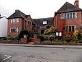
Silvester Horne Institute, High Street: used for public gatherings and meetings of the town council.
-
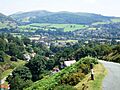
The northern parts of the town, from the Burway.
-
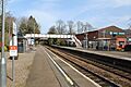
A view of the station, looking north towards Shrewsbury.
-
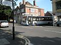
A Minsterley Motors bus turning off Beaumont Road onto Sandford Avenue.
-
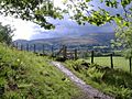
A stile and footpath with view of the Long Mynd.
-
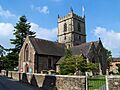
St Laurence's Church – the town's ancient parish church.
-
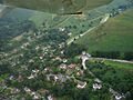
Aerial photo of part of the town in 2008, showing the entrance to Carding Mill Valley and the Golf Club's clubhouse.
-
The town centre viewed across Russell's Meadow.
-
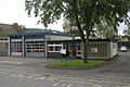
The town's fire station on Sandford Avenue.
-
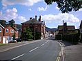
Shrewsbury Road (the B5477), looking south towards the town centre.

See also
 In Spanish: Church Stretton para niños
