
Stiperstones facts for kids
Quick facts for kids Stiperstones |
|
|---|---|

Manstone Rock
|
|
| Highest point | |
| Elevation | 536 m (1,759 ft) |
| Prominence | 357 m (1,171 ft) |
| Parent peak | Plynlimon |
| Listing | Marilyn |
| Geography | |

Stiperstones
Location in England
|
|
| Location | Shropshire, England |
| Topo map | OS Landranger 137 |

The Stiperstones (also known as Welsh: Carneddau Teon) is a special hill in Shropshire, England. It stands out because of its unique rocky top. The rocks that make up this hill are called quartzite. They were formed about 480 million years ago!
A long time ago, during the last Ice Age, the Stiperstones was on the edge of a huge sheet of ice from Wales. Even though the hill itself wasn't covered by ice, the valleys around it were. The extreme cold caused the rocks to freeze and thaw over and over again. This broke the quartzite into many pieces, creating piles of jumbled rocks called scree. You can still see several tall, rocky towers, known as tors, sticking out from these piles.
At 536 meters (about 1,759 feet) above sea level, the Stiperstones is the second-highest hill in Shropshire. Only Brown Clee Hill is taller. The top ridge of the Stiperstones is about 8 kilometers (5 miles) long. It has several sharp, jagged rock outcrops that look amazing against the sky.
Contents
What are the Stiperstones' main rocks?
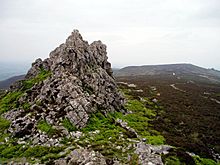
The Stiperstones is famous for its rocky towers, or tors, made of quartzite. These are the main ones, listed from north-east to south-west:
- Shepherd's Rock
- Devil's Chair
- Manstone Rock
- Cranberry Rock
- Nipstone Rock
- The Rock
Manstone Rock is the tallest of these tors, reaching 536 meters (1,759 feet). It has a special marker called a trig point at its very top. The Devil's Chair is the biggest and most well-known of all the tors.
From the Stiperstones ridge, you can get amazing views of the Shropshire Hills. You can see the Long Mynd to the east. You can also look out over the flat lands of North Shropshire and the hills of Mid Wales.
How did the Stiperstones rocks form?
The rocky towers of the Stiperstones are made from a type of rock called Stiperstones Quartzite Formation. This rock is a hard, grey-white sandstone that formed during the Ordovician period. It's between 120 and 325 meters thick!
The ground around the tors is often covered in a gravelly and rocky layer. This layer formed during the current Quaternary period from the rocks below. You can also find some isolated areas of peat (decayed plant matter) in certain spots. What's really cool are the special patterns on the ground around the tors. These are some of the best examples in England of features called stone stripes and polygons. They were created by freezing and thawing during very cold times, a process known as periglaciation.
Wildlife and nature conservation
The Stiperstones is a very important place for nature. It is a National Nature Reserve and a Site of Special Scientific Interest (SSSI). This means it's protected because of its special wildlife and geology. It's also part of the Shropshire Hills Area of Outstanding Natural Beauty.
Many birds that usually live in upland areas make their home here. These include red grouse, Eurasian curlew, peregrine falcon, and the rare ring ouzel.
A special project called "Back to Purple" has started here. Its goal is to clear away some of the planted pine trees and other conifers. The aim is to bring back the natural heather-based heathland. This way, the hills will be covered in beautiful purple-flowering heather during certain seasons. This will make the views of the Stiperstones even better from nearby peaks and valleys.
The "Back to Purple" project is run by a team including Natural England, Forest Enterprise (part of the Forestry Commission), and the Shropshire Wildlife Trust. They have already removed thousands of pine trees. For example, the whole Gatten Plantation was removed, and Nipstone Rock, which was once hidden by trees, can now be seen clearly. Thousands of new heather plants have been successfully planted.
To make the area even better, work is also being done below the main summit. This work aims to bring back grasslands rich in different plants, hay meadows, and wet areas that grow bog cotton, Heath Bedstraw, and the rarer Mountain Pansy. Natural woodlands are also being restored.
The Bog Mine and Visitor Centre
Until the early 1900s, lead was mined at a place called The Bog, just west of the Stiperstones. The mine and the nearby Stiperstones rocks were good for mining because of how the Earth's layers moved over time. This movement caused the rock layers to crumple, and the softer parts wore away, leaving valuable minerals.
After the mining stopped, the old mine site became a great home for wildlife. Birds nest in the old buildings, and bats live in the old mine tunnels. The reservoirs and ponds are perfect for water animals and plants.
The Bog Visitor Centre is the main place for people visiting the Stiperstones. It's located in the old village school and still looks like it did back then. Inside, you can learn about the miners who used to work there, the history of mining, and the current efforts to restore the landscape. The center has toilets and parking, including special facilities for people with disabilities.
You can enjoy activities like walking, with two main circular paths called Mucklewick Walk and Flenny Bank Walk. There are also various routes for horse riding.
The 2012 fire
On July 25, 2012, a part of the nature reserve was badly damaged by a fire. This fire happened because of very dry, hot weather and a lot of dry heather on the hills. More than 70 firefighters worked from 3 PM to 10 PM to put out the fire. Smoke from the fire could be seen up to 10 miles away in the town of Shrewsbury. Firefighters stayed at the site all night because the fire was so serious and covered a large area.
Gallery
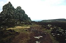
-
The Devil's Chair, looking northwards.
-
The Stiperstones appear in books by Mary Webb and children's author Malcolm Saville.


See also
 In Spanish: Stiperstones para niños
