
Brown Clee Hill facts for kids
Quick facts for kids Brown Clee Hill |
|
|---|---|

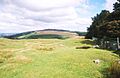
Brown Clee Hill, looking towards Abdon Burf
|
|
| Highest point | |
| Elevation | 540 m (1,770 ft) |
| Prominence | 373 m (1,224 ft) |
| Parent peak | Plynlimon |
| Listing | Marilyn, County Top |
| Geography | |

Brown Clee Hill
Location in Shropshire
|
|
| Location | Shropshire, England |
| OS grid | SO593865 |
| Topo map | OS Landranger 138 |
Brown Clee Hill is the tallest hill in Shropshire, a beautiful county in England. It stands 540 meters (about 1,772 feet) high. This hill is part of the Clee Hills and is located in the amazing Shropshire Hills Area of Outstanding Natural Beauty.
Contents
Where is Brown Clee Hill?
Brown Clee Hill is about five miles north of its sister hill, Titterstone Clee Hill. The very top of Brown Clee Hill is called Abdon Burf, which is 540 meters high. Another peak, Clee Burf, is 510 meters high.
Much of Brown Clee Hill is private land. Large areas are covered with tall, pointy evergreen trees. The eastern part of the hill belongs to the Burwarton Estate. Other parts are owned by different people and the local village of Clee St. Margaret.
You can find the remains of an Iron Age hill fort on the common land. This ancient fort is a cool reminder of history.
Nearby towns include Ludlow, Cleobury Mortimer, Church Stretton, Broseley, Bridgnorth, and Much Wenlock.
What Can You See on the Hill?
You might notice several tall air traffic control radar masts at the top of the hill. These masts help guide airplanes. They work with other masts on Titterstone Clee Hill. Together, they can see all aircraft within a hundred miles.
There is also a toposcope at the summit. This is a special marker that points out local landmarks. It helps you identify different places you can see from the top.
How Was Brown Clee Hill Formed?
Brown Clee Hill is made of different kinds of rock. These rocks formed during the Carboniferous period. The lower areas around the hill have older rocks. The top of the hill is covered with a very hard igneous rock.
The lower parts of the hill are made of sandstone and conglomerates. These are types of sedimentary rock. On top of these are mudstones, which contain coal seams.
The very top of Abdon Burf and Clee Burf is made of a dark rock called dolerite. People in the area call it 'dhustone'. This hard rock was pushed up into the other rocks a long time ago. It has resisted erosion, which is why it forms the hilltops.
A Look Back in Time: History of Brown Clee Hill
Brown Clee Hill has a rich history, from ancient forts to busy quarries.
Ancient Hill Forts
Several Iron Age hill forts were built around the Clee Hills. Nordy Bank is the best-preserved of three hill forts on Brown Clee. The other two, at Abdon Burf and Clee Burf, have mostly disappeared due to quarrying.
Nordy Bank sits on a sloping ridge. Its walls are up to three meters high. It was built thousands of years ago, during the British Iron Age. From here, people had an excellent view of the countryside.
Quarrying for Dhustone
For a long time, quarrying was the main way people earned money in the area. It was very hard and dangerous work. People would walk to the Abdon Quarry on Brown Clee Hill from towns like Bridgnorth and Ludlow. They often had other jobs too.
They were quarrying for 'Dhustone', which is dolerite. This rock is very hard and tough to get out of the ground.
End of an Era
The Abdon Clee quarries closed in 1936. By then, the area had become quite industrial. There was a concrete plant and a tarmac plant nearby. A small railway helped move the stone. People could even hear the stone crusher working from Cleehill village on windy days.
After these quarries closed, many quarrymen went to work at the Cockshutford quarries. But the dhustone there was not as good. That quarry also closed. Many men then worked at a naval ammunition depot in Ditton Priors during World War II. The quarries on Brown Clee completely stopped working in the 1930s and 1940s.
World War II Plane Crashes
Even though the radar facilities on the Clee Hills now protect aircraft, both hills were once dangerous for planes. A special memorial was put up in 1981. It remembers 23 Allied and German airmen who died when their planes crashed into Brown Clee during World War II. It also remembers those from a Jet Provost plane that crashed in 1969.
The first plane to crash here was a German Junkers 88 on April 1, 1941. Two Wellington Bombers, a Hawker Typhoon, and at least two Avro Ansons also crashed on the hill. It is believed that Brown Clee had more wartime plane crashes than any other hill in Britain. Parts of one of the Wellington Bombers are said to be at the bottom of Boyne Water, near Brown Clee.
Views from the Top

Images for kids
-
Brown Clee Hill, looking towards Abdon Burf
