
Titterstone Clee Hill facts for kids
Quick facts for kids Titterstone Clee Hill |
|
|---|---|

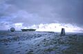
The summit under snow, with radar station beyond.
|
|
| Highest point | |
| Elevation | 533 m (1,749 ft) |
| Prominence | 232 m (761 ft) |
| Parent peak | Brown Clee Hill |
| Listing | Marilyn |
| Geography | |

Titterstone Clee Hill
Location in Shropshire
|
|
| Location | Shropshire, England |
| Parent range | Shropshire Hills |
| OS grid | SO591779 |
| Topo map | OS Landrangers 137, 138 |
Titterstone Clee Hill is a well-known hill in the English county of Shropshire. It stands tall at 533 meters (1,749 feet) above sea level. People sometimes call it Titterstone Clee. However, it's important not to confuse it with the lower Clee Hill nearby.
This hill is part of the Clee Hills, which are located in the beautiful Shropshire Hills Area of Outstanding Natural Beauty. The closest town is Ludlow. You can even see parts of Ludlow from the village of Cleehill, which sits on the side of Titterstone Clee.
Contents
About Titterstone Clee Hill
Titterstone Clee is the third-highest hill in Shropshire. Only Brown Clee Hill (540 meters) and Stiperstones (536 meters) are taller. Much of the higher part of the hill is common land. This means it's open for things like grazing sheep. It also hosts important air traffic control services.
The top of Titterstone Clee looks quite bare. There are no trees, and its shape has changed over many years. This is due to quarrying, which is the process of digging out stone. You can still see many old industrial buildings from this activity.
Human Impact on the Hilltop
People have changed the summit of the hill a lot over time. In the Bronze and Iron Ages, ancient people built hill forts here. More recently, people mined for coal and quarried for a hard rock called dolerite. This rock is known locally as 'dhustone'. It was used to build roads.
Many old quarry buildings are scattered across the hill. These buildings are interesting because they show early examples of how reinforced concrete was used.
Villages on the Hill
The village of Cleehill is located on a road that crosses the hill. It sits at 395 meters (1,296 feet) above sea level. This village was once home to the highest pub in Shropshire, called The Kremlin. It also had the highest primary school. On the northeast side of the hill, you'll find the small village of Cleeton St Mary.
Understanding the Hill's Geology
Titterstone Clee stands out because of its special geology. The igneous rocks that cap both Titterstone Clee and Clee Hill are very strong. They resist erosion better than the softer rocks around them. Most of the lower ground is made of mudstones and sandstones. These rocks are from the Devonian age.
The very top part of these rocks is called the St Maughans Formation. On the north and west sides, it reaches almost to the summit. There, it is covered by a very hard dolerite sill. A similar, but larger, rock layer covers Clee Hill to the south.
Rocks and Minerals
The dark dolerite rock from the sill is called Dhu Stone by local people. 'Dhu' might come from the Welsh word 'du', meaning 'black'. This rock is a type of basalt. It seems to have pushed its way between layers of sandstone. This happened when the sediments were still soft.
The hill also has Carboniferous Limestone and Millstone Grit. These rocks are found in different areas around the hill. Above these are mudstones, siltstones, and sandstones. These make up most of the hill's surface. They contain layers of coal and seatearth that people used to mine. The lowest and largest coal layer is called the 'Gutter Coal'.
Giant's Chair
Near the summit, you can find a pile of large rocks called the Giant's Chair. These are boulders that were formed during very cold periods. This happened during the Devensian ice age.
History of Quarrying and Land Use
Near the summit's trig point, you can see the remains of a Bronze Age cairn. This stone pile is up to 4,000 years old. It suggests the summit was once a special ceremonial place. Titterstone Clee also has an Iron Age hill fort. It is surrounded by huge earthworks. The walls of this fort are made of stone blocks, not just earth banks.
Clee Hill is one of the few hills shown on the Hereford Mappa Mundi. This is a famous 13th-century map of the world. It is displayed at Hereford Cathedral.
Mining and Quarrying History
In medieval times, people mined for ironstone and later for coal. They used bell pits, which are small, deep mine shafts. One of these shafts has now filled with water and become a lake. Over the years, many quarries opened on Titterstone Clee. They were used to dig out the dolerite rock. Today, only one quarry, on Clee Hill, is still active. The largest old quarries have sheer drops of about 30 meters (100 feet).
Before the Second World War, this area was very industrial. There was a lot of quarrying and related work. Men traveled from places like Bridgnorth and Ludlow to work in the quarries. The villages of Bedlam and Dhustone were built for these workers. Now, crumbling quarry buildings are all over the hill. They remind us of an industry that once employed over 2,000 people here.
An old narrow gauge railway incline is still visible on the hill. A large concrete structure where wagons were filled with stone remains near the modern car park. A standard gauge railway incline also helped transport stone from above Cleehill village. This railway system was used until the early 1960s. In the past, people also mined for coal, fireclay, and limestone here.
In the early 1900s, a large quarry called Magpie Quarry opened. It was on the eastern side of Clee Hill. An aerial ropeway was built to carry stone off the hill to the railway at Detton Ford. You can still see the footings for the tall pylons that held the wires. They are near the summit, next to the modern track to the radar domes.
Quarrying still happens behind Cleehill village. It started again in the late 1980s. This was 50 years after the Titterstone Clee Dhustone quarry closed. The main quarry buildings are cleverly hidden by landscaping.
Modern Uses of the Summit
Several radar domes and towers are located on the summit of the hill. The largest radar is part of the National Air Traffic Services (NATS) network. It monitors aircraft within a 100-mile radius. This covers one of 30 areas of UK airspace. The smaller radar is a Met Office weather radar station. It is one of 16 across the country used to detect rain. These domes and masts are well-known local landmarks. One of them is often called 'the golf ball'.
A 20th-century triangulation pillar also marks the summit.
Exploring and Enjoying the Hill
The summit and upper slopes of Titterstone Clee are open for walkers. This is thanks to the Countryside and Rights of Way Act 2000. There are also many footpaths and bridleways. These paths cross both the open land and the surrounding farmland. Some paths connect from the A4117 road. This road runs across Clee Hill Common's southern side. It reaches 381 meters (1,250 feet) high. A smaller public road also goes to the upper parts of the hill. There are parking areas there.
Titterstone Clee is popular with walkers and people who enjoy picnics. However, it is less busy than nearby hills like the Long Mynd. From the summit, the Shropshire Way trail runs north to Brown Clee Hill. It also goes southwest to Ludlow and east to Cleobury Mortimer. Another long-distance trail, the Jack Mytton Way, runs along the northeast edge of the hill.
On a clear day, the views from the hill are amazing. You can see west to Snowdonia and northeast to the Peak District. To the east, you might see the Black Country. The Cotswolds are to the southeast. To the south, you can spot the Malvern Hills. And to the southwest, you might see the Black Mountains and Brecon Beacons. Many say this hill offers one of the best views in England on a clear day.
Titterstone Clee in Stories
Titterstone Clee plays an important part in the Ellis Peters novel The Virgin in the Ice.
Images for kids
-
The summit under snow, with radar station beyond.
