
Malvern Hills facts for kids
Quick facts for kids Malvern Hills |
|
|---|---|

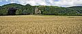
Malvern Hills, looking northwest. Upper Welland is visible in the foreground.
|
|

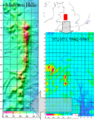
Location of the Malvern Hills AONB in the UK
|
|
| Location | England |
| Length | 13 km (8.1 mi) |
| Area | 12 km2 (4.6 sq mi) |
| Elevation | 425 metres (1,394 ft) |
| Established | 1959 |
| Governing body | Malvern Hills Conservators Malvern Hills AONB Partnership |
| Website | www.malvernhills.org.uk, www.malvernhillsaonb.org.uk |
| Site of Special Scientific Interest | |
| Area of Search | Herefordshire, Worcestershire, Gloucestershire |
|---|---|
| Grid reference | to |
| Interest | Biological/Geological |
| Area | 732.3 hectare |
| Notification | 1954 |
The Malvern Hills are a beautiful range of hills in England. They stretch across parts of Worcestershire, Herefordshire, and a small bit of northern Gloucestershire. These hills stand tall over the nearby towns and villages, especially Malvern. From the highest point, you can see amazing views. You can spot the Severn Valley, other hills, Welsh mountains, and even the Bristol Channel. On a clear day, you might even see the cathedrals of Worcester, Gloucester, and Hereford!
The Malvern Hills are famous for their pure spring water. This water first became well-known because of the many holy wells in the area. Later, in the 1800s, Great Malvern grew into a popular spa town. Today, Malvern water is bottled and sold all over the world.
These hills are also very important for nature. They are a Site of Special Scientific Interest (SSSI) for both their plants and animals, and their unique rocks. Natural England has also named them an Area of Outstanding Natural Beauty (AONB). The Malvern Hills Trust helps look after the hills.
Contents
What's in a Name?
The name Malvern probably comes from an old British language. It might mean "Bare-Hill" or "Bald Hill." The closest modern word is the Welsh moelfryn. Over time, the name has changed from Malferna in the 1000s to Malverne in the 1100s.
Exploring the Malvern Hills
The Malvern Hills are part of a special area known for its amazing scenery. They run from north to south for about 13 kilometers (8 miles). They are located between Great Malvern and the village of Colwall. To the east, you can see the River Severn valley and the Cotswolds beyond.
The highest point is the Worcestershire Beacon, which is 425 meters (1,395 feet) above sea level. The hills are well-known for their natural mineral springs and wells. These springs helped Great Malvern become a popular spa town in the early 1800s.
There are three main paths or "passes" that cross the hills. These include the Wyche cutting, the A438 road, and the A449 road. Near the A449 road is the British Camp, an ancient Iron Age hill fort. This fort is very old, possibly from before the year 0. It was later used as a medieval castle. You can still see the large earthworks (old walls and ditches) today.
The Rocks of Malvern

The Malvern Hills are made of some of the oldest rocks in England. Most of these rocks are igneous and metamorphic rocks. They are from the late Precambrian period, which means they are about 680 million years old!
The Malvern Line is a special line of faults and folds that runs through the hills. This line brings the very old Malvernian rocks to the surface. These rocks are very hard and have resisted erosion better than the surrounding land. This is why the Malvern Hills stand out so much. This line also marks where two different parts of the Earth's crust meet.
At Gullet Quarry, you can see a cross-section of these ancient rocks. You can find many types of rocks there, like diorite, granite, and gneiss. You can also see signs of how the Earth moved to form the hills. There are many cracks, breaks, and faults in the rocks.
There's a small, man-made cave called Clutter's Cave near the top of the hills. It was dug into pillow lavas, which are rocks formed from lava flowing underwater. You can still see some of the rounded "pillow" shapes near the cave entrance.
Malvern Water: A Natural Filter

The amazing quality of Malvern water comes from its source. The rocks of the Malvern Hills are some of the oldest and hardest in England. These rocks are responsible for the water's purity. The hills are made of ancient Precambrian igneous and metamorphic rocks.
Rainwater and melted snow soak through tiny cracks in these rocks. These cracks were made by huge Earth movements about 300 million years ago. As the water passes through the hard rock, it picks up very few minerals. The tiny cracks also act like a natural filter, removing impurities. The amount of water flowing from the springs changes with rainfall. It can range from 36 liters (9.5 gallons) per minute to over 350 liters (92 gallons) per minute!
Nature on the Hills
The Malvern Hills are a Site of Special Scientific Interest (SSSI) and an Area of Outstanding Natural Beauty (AONB). This means they are protected for their special wildlife and landscapes.
You can find wide areas of grassy hills and heath at the top. On the lower slopes and in the valleys, there are mixed forests and very old Ancient Semi-Natural Woodland. Some of these ancient woodlands include Hollybush Roughs, Park Wood, and an area near Holy Well.
Important animals and plants living here include the dormouse, barbastelle bat, skylark, and the great crested newt. You might also spot an adder (a type of snake) or a black poplar tree.
A Look Back in Time

People have lived in the Malvern Hills area for a very long time. Tools like flint axes and arrowheads from the early Bronze Age have been found here. The 'Shire Ditch', an old earthwork, was built around 1000 BC. The Wyche Cutting, a pass through the hills, was used in ancient times for a salt trading route.
An old story says that the British leader Caractacus made his last stand against the Romans at the British Camp. This camp is a huge Iron Age hill fort on one of the Malvern Hills. While the story is debated, other nearby forts show signs of being destroyed around 48 AD. This might mean British Camp was also abandoned or destroyed around that time.
During the Middle Ages, the hills were part of a Royal forest called Malvern Chase. In 1884, the Malvern Hills Conservators were created by a special law. Their job was to protect the hills and keep them natural. However, large-scale quarrying (digging for stone) had already started. Quarrying continued until 1966, changing the landscape forever. But these quarries also created new homes for frogs, toads, and newts.

In 2000, a big project started to bring grazing animals back to the Malvern Hills. This project also aimed to fix up old water spouts. Grazing animals, like Dexter cattle, help manage the land naturally. In 2001, the Malvern Hills were closed to the public for the first time ever to stop the spread of foot and mouth disease. This closure really hurt the local economy.
Who Looks After the Hills?

The Malvern Hills Trust (also known as the Malvern Hills Conservators) manages most of the hills and the surrounding common lands. They were set up in 1884 and follow special laws called the Malvern Hills Acts. They have 29 members, some elected by local residents and others appointed by local councils. They look after over 1,200 hectares (3,000 acres) of land.
The Malvern Hills were named an Area of Outstanding Natural Beauty (AONB) in 1959. This special area covers about 105 square kilometers (41 square miles). The Malvern Hills Conservators helped make sure the AONB was larger than first planned. The AONB Partnership works together to protect and improve the Malvern Hills AONB.
Fun on the Malvern Hills

The Malvern Hills are a great place for outdoor activities! You can go walking, mountain biking, horse riding, or even hang-gliding.
- The Worcestershire Way is a 50-kilometer (31-mile) walking trail that runs from Bewdley to Great Malvern. It's a popular way to explore the AONB.
- The Geopark Way is a longer trail, about 109 miles (175 km) long. It goes from Bridgnorth to Gloucester and passes through the Abberley and Malvern Hills Geopark. This route shows off the area's amazing geology and landscape.
- The Malvern Hills Geocentre, located at the Wyche, is a visitor center. Here, you can learn more about the geology, nature, and history of the Geopark and the Malvern Hills.
Abberley and Malvern Hills Geopark
The Abberley and Malvern Hills Geopark was created in 2004. It covers a huge area of 1,250 square miles (3,200 km²) across four counties. This area is known for its important geological features. It has 13 Sites of Special Scientific Interest (SSSI) and many other important geological sites. It is one of only seven geoparks in the UK.
Getting Around
The A449 road goes right through Malvern, connecting it to Worcester and Ledbury. You can also reach the M5 motorway easily from Malvern.
There are four train stations in or near the AONB: Malvern Link, Great Malvern, Colwall, and Ledbury. These stations are on the Cotswold Line, which connects to places like Oxford and Hereford. You can also get direct trains from Birmingham and London.
Local bus services connect Malvern to nearby areas. There are also long-distance bus services that can take you to other cities in the country.
Malvern Hills in Arts and Culture
Music Inspired by the Hills

The famous English composer Edward Elgar lived nearby and loved the Malvern Hills. He often walked, cycled, and even flew kites there. In 1898, he wrote a piece of music called Caractacus, which was inspired by the legend of Caractacus at British Camp. Elgar once said that if anyone heard his Cello Concerto tune whistled on the Malvern Hills after he was gone, it would just be him!
Other composers like Herbert Howells and Ivor Gurney also found inspiration in the beauty of the Malverns. The Swedish singer Jenny Lind spent her last years living near British Camp. She is buried in Great Malvern cemetery.
Literature and the Malvern Hills
The Malvern Hills were the setting for the famous 14th-century poem The Visions of Piers Plowman by William Langland. The poem begins with the line: "And on a Maye mornynge on Malverne hylles."
The poet W. H. Auden taught at The Downs School in Colwall for three years. He wrote some of his early love poems and a long poem called The Malverns while living there.
J. R. R. Tolkien, the author of The Hobbit and The Lord of the Rings, found inspiration in the Malvern landscape. He walked the hills with his friend C. S. Lewis. Recordings of Tolkien reading from his books were even made in Malvern in 1952. He compared parts of the Malvern Hills to the White Mountains of Gondor in his books.
The poet Elizabeth Barrett Browning grew up near the Malvern Hills. Her childhood home inspired her novel Aurora Leigh.
Some people believe that a ley line (a straight line connecting ancient sites) passes along the Malvern Hills. This line is said to connect several wells like St Ann's Well and Holy Well.
The legend of the Shadow of the Ragged Stone is also linked to the hills. This shadow is said to bring bad luck to anyone it falls on. It's the subject of a novel by Charles F. Grindrod.
Art and Television
Many artists have painted the Malvern Hills, including Henry Harris Lines and David Prentice. Paul Nash and Dame Laura Knight also painted scenes from the hills.
The Malvern Hills have appeared on television too.
- The opening scene of Elgar, a 1962 documentary about the composer, shows a young Elgar riding a pony on the hills.
- Parts of the Doctor Who episode The Krotons were filmed in the Tank Quarry and West of England Quarry in 1968.
- The hills are the backdrop for Penda's Fen, a 1974 TV play. The final scene, where the main character has visions, is set on the Malvern Hills.
The Hills Themselves

Here is a list of the main hills from north to south:
| Hill | Elevation (ft) | Elevation (m) |
|---|---|---|
| End Hill | 1,079 | 329 |
| Table Hill | 1,224 | 373 |
| North Hill | 1,303 | 397 |
| Sugarloaf Hill | 1,207 | 368 |
| Worcestershire Beacon | 1,395 | 425 |
| Summer Hill | 1,253 | 382 |
| Perseverance Hill | 1,066 | 325 |
| Jubilee Hill | 1,073 | 327 |
| Pinnacle Hill | 1,174 | 358 |
| Black Hill (north) | 1,011 | 308 |
| Black Hill (south) | 886 | 270 |
| Tinkers Hill | 700 | 213 |
| Herefordshire Beacon (British Camp) | 1,109 | 338 |
| Millennium Hill | 1,073 | 327 |
| Broad Down | 958 | 292 |
| Hangman's Hill | 906 | 276 |
| Swinyard Hill | 889 | 271 |
| Midsummer Hill | 932 | 284 |
| Hollybush Hill | 794 | 242 |
| Raggedstone Hill (east top) | 820 | 250 |
| Raggedstone Hill (west top) | 833 | 254 |
| Chase End Hill | 625 | 191 |
You can get a great view of the hills from the M5 motorway, especially between Junction 7 (south of Worcester) and Junction 9 (Tewkesbury).

Amazing Views
Visitors to the Malvern Hills often say that the "scenery and views" are what they love most. The hills stand out like an island from the lower land around them. This makes them easy to spot from far away. They are a well-known feature in the local landscape.
A study in 2009 looked at the best views from and to the Malvern Hills. This was done to help share these beautiful spots with more people. It also helped to understand how new buildings, like wind turbines, might affect the views. The study found 50 key viewpoints.
Here are some of the best places to see the views:
- North Hill, Worcestershire Beacon, Herefordshire Beacon (British Camp), and Chase End Hill all offer amazing 360-degree views.
- From the B4232 at Upper Wyche, you can see Great Malvern and Worcester City in the distance.
- Near Eastnor Castle, you can find another great spot for panoramic views.
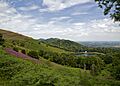
- From A4104 west of Welland, you get a wide view of the eastern side of the hills.
Views from outside the AONB are also special:
- From the A4103 near Leigh Sinton, you get a wide, open view of the Malvern Hills rising from flat fields.
- The Ketch viewpoint at the southern edge of Worcester offers a wide view over the River Severn floodplain.
- Bredon Hill has an exceptional 360-degree view. From here, you can see the eastern side of the Malvern Hills.
- Clent Hills Country Park also offers long-distance views of the Malvern Hills to the southwest.
Images for kids
-
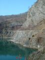
Gullet Quarry, showing different rock layers.
-
St. Ann's Well, a popular spot for walkers.
-
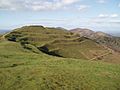
Ancient earthworks at British Camp.
-
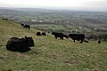
Dexter cattle grazing on the Malvern Hills.
-
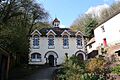
The Holy Well, Malvern.
-
Malvern Hills with the British Camp on the left.
-
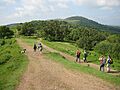
People enjoying a walk on the Malvern Hills.
-
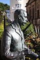
Statue of Sir Edward Elgar in Great Malvern.
-
Location of the Malvern Hills within England.
-
Panorama of the Malvern Hills (AONB) with Little Malvern Priory taking centre stage.

