
Clent Hills facts for kids
Quick facts for kids Clent Hills |
|
|---|---|

The four stones at the top of Clent Hill at 52° 25′ 15.29″ N, 2° 5′ 56.12″ W
|
|
| Highest point | |
| Elevation | 315 m (1,033 ft) |
| Prominence | 45 m (148 ft) |
| Geography | |
| Location | Worcestershire, England |
| OS grid | SO942797 |
The Clent Hills are a beautiful group of hills located about 10 miles (16 km) southwest of Birmingham city centre in Worcestershire, England. Nearby towns include Stourbridge and Halesowen. These hills are a popular spot for outdoor activities.
The Clent Hills range includes several hills. From northwest to southeast, you'll find Wychbury Hill, Clent Hill (which also includes Adams Hill), and Walton Hill (with Calcot Hill). This chain of hills continues eastward, connecting to Romsley Hill, Waseley Hills, and the Lickey Hills.
Clent Hill is the most visited part of the range. Many people refer to the entire area simply as the Clent Hills. Nearly a million visitors come here each year. This makes the Clent Hills Worcestershire's most popular free attraction.
Contents
What are the Clent Hills Made Of?
The Clent Hills are mainly made of a type of rock called Clent Breccia. This rock is mostly a reddish-brown mudstone. It formed during the early Permian period, a very long time ago.
This rock layer sits on top of older mudstones and sandstones. These older rocks make up the lower ground to the north and east. Many cracks, called faults, run through the bedrock. Most of these faults point from northeast to southwest.
Exploring the Clent Hills

The Clent Hills and the Lickey Hills together form a long chain of hills in northern Worcestershire. This chain is sometimes called the Clent-Lickey range. The tallest of the Clent Hills is Walton Hill, which stands at 1,037 feet (316 meters) high. Clent Hill is slightly lower at 1,014 feet (309 meters).
A valley known as St. Kenelm's Pass separates these two main hills. This valley starts as a steep slope. Water flowing down this slope feeds into streams that eventually become the River Stour. On the other side of the pass, a stream flows down into Clent village.
In the past, people used to build dams along this stream. These dams helped power watermills. You can still see the remains of one such dam behind the Vine Inn in Clent. This building was once a mill.

On either side of the two largest hills are two smaller ones. Wychbury Hill is next to Clent Hill. Calcot Hill is next to Walton Hill. Calcot Hill is actually part of a long ridge that extends from the top of Walton Hill. A public path connects these two hills.
Another deep valley runs alongside this ridge. This valley also had dams to power mills. The stream here flows towards the village of Belbroughton. The Nash Crown Scythe Works in Belbroughton used this water to power its machines.
The National Trust owns about 440 acres (178 hectares) of land on the hills. This land includes both natural deciduous woodlands and coniferous forest plantations. It's an important home for wildlife. You might spot fallow deer and common buzzards. Sometimes, ring ouzels and common crossbills visit too.
A Glimpse into History
The Clent Hills have a long history. The name "Clent" might come from an old Scandinavian word for "cliff." Long ago, this area was part of a forest in Mercia. On Wychbury Hill, you can still see the remains of an Iron Age hillfort. This was a fortified settlement from ancient times.
Around the 1750s, Lord Lyttelton of Hagley Hall added several classical structures to the hills. Many of these are on private land but can be seen from public areas. In 1758, Lord Lyttelton built the Wychbury Obelisk on Wychbury Hill. This tall monument can be seen from miles away. He also built other interesting structures, like small Greek and Roman temples. He even built a mock ruined castle and The Four Stones on top of Clent Hill.
The Clent Hills are also linked to the legend of St. Kenelm. He was said to have been murdered on a hunting trip here in 821 AD. The church of St. Kenelm in Romsley marks the spot of his murder. This church is also the starting point for the 60-mile (97 km) long St Kenelm's Trail walk.
The tops of Clent Hill and Walton Hill are now owned by the National Trust. These areas have been protected and managed for public enjoyment for many years. In 1974, the hills became a country park. Since 1995, the National Trust has managed them.
Beacons on the Hills
Beacons have been lit on the Clent Hills for centuries to send messages. In 1588, a beacon was placed on Bicknall. This was part of a chain of fires used to warn of the approaching Spanish Armada.
In 1897, for Queen Victoria's Diamond Jubilee, many beacons were lit across the country. The poet A. E. Housman watched from Walton Hill. He saw 52 beacons to the south and west. He noted that the Clent Hill beacon was on the southwest side, not the very top.
More recently, beacons have been lit for royal jubilees. In 1977, a bonfire beacon was lit on Walton Hill for Queen Elizabeth II's Silver Jubilee of Elizabeth II. Another was lit on Clent Hill in 2012 for her Golden Jubilee of Elizabeth II. This beacon was 12 feet (3.7 meters) high and 8 feet (2.4 meters) wide.
Amazing Views from the Clent Hills

From the top of Walton Hill, at 1,037 feet (316 meters), you can see incredible views. You can spot the Malvern Hills, Kinver Edge, The Wrekin, and the Clee Hills. On a clear day, you might even see the Black Mountains in Wales. You can also see parts of the northern Cotswolds and the southern Peak District.
A special sign, called a toposcope, helps you identify the distant mountains. Other landmarks visible include Dudley Castle and the Wychbury Obelisk. Because of these amazing views, the hills are very popular with hillwalking visitors and local walking groups. Many public footpaths crisscross the hills.
One popular way to reach Clent Hill is from Nimmings car park. From there, an easy path leads to the ridge. Another access point is the public car park on Adams Hill. Adams Hill is a hamlet and the slope on the southwest side of Clent Hill.
In 2009, experts studied the views from the Clent Hills. They found that the view towards the Malvern Hills, about 22 miles (35 km) away, was one of the most distant and special. They described a "180-degree panoramic view" from the hills. This view shows many other hill ranges and a generally rural setting.
Clent Hills and Culture
The poet William Shenstone lived near the Clent Hills at The Leasowes. He was a neighbor of the Lyttelton family at Hagley Hall. Shenstone's garden at The Leasowes was very famous in the mid-1700s. His ideas about gardening were quite influential.
In 2012, writer Helen Calcutt became the first writer-in-residence for the Clent Hills. She spent three months talking to visitors. She then turned their thoughts into a poem called 'Poem to Clent'. Lines from this poem can be found on the new Clent Hills archway.
Images for kids
-
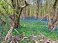
A bluebell wood in the Clent Hills.

