
Worcestershire facts for kids
Quick facts for kids
Worcestershire
|
|||||||||||||||||||||||||||||||||||||||||||||||||||||
|---|---|---|---|---|---|---|---|---|---|---|---|---|---|---|---|---|---|---|---|---|---|---|---|---|---|---|---|---|---|---|---|---|---|---|---|---|---|---|---|---|---|---|---|---|---|---|---|---|---|---|---|---|---|
|
Worcester; Broadway Tower in the Cotswolds, and the Malvern Hills on the Worcestershire–Herefordshire border
|
|||||||||||||||||||||||||||||||||||||||||||||||||||||

Worcestershire within England
|
|||||||||||||||||||||||||||||||||||||||||||||||||||||
| Sovereign state | United Kingdom | ||||||||||||||||||||||||||||||||||||||||||||||||||||
| Constituent country | England | ||||||||||||||||||||||||||||||||||||||||||||||||||||
| Region | West Midlands | ||||||||||||||||||||||||||||||||||||||||||||||||||||
| Established | 1 April 1998 | ||||||||||||||||||||||||||||||||||||||||||||||||||||
| Established by | Local Government Commission for England | ||||||||||||||||||||||||||||||||||||||||||||||||||||
| Preceded by | Hereford and Worcester | ||||||||||||||||||||||||||||||||||||||||||||||||||||
| Origin | Ancient | ||||||||||||||||||||||||||||||||||||||||||||||||||||
| Time zone | UTC±00:00 (Greenwich Mean Time) | ||||||||||||||||||||||||||||||||||||||||||||||||||||
| • Summer (DST) | UTC+01:00 (British Summer Time) | ||||||||||||||||||||||||||||||||||||||||||||||||||||
| Members of Parliament | 6 MPs | ||||||||||||||||||||||||||||||||||||||||||||||||||||
| Police | West Mercia Police | ||||||||||||||||||||||||||||||||||||||||||||||||||||
|
|||||||||||||||||||||||||||||||||||||||||||||||||||||
.jpg)
.jpg)


Worcestershire (pronounced WUUST-ər-shər or WUUST-ər-sheer) is a county in the West Midlands of England. It shares borders with Shropshire, Staffordshire, and the West Midlands county to the north. To the east, it borders Warwickshire, to the south Gloucestershire, and to the west Herefordshire. The city of Worcester is the largest town and the main county town.
Worcestershire is mostly a rural area, covering about 1,741 square kilometers (672 square miles). Around 592,057 people live here. Besides Worcester, other big towns include Redditch, Kidderminster, and Malvern. The county has six local government areas.
The River Severn, one of the longest rivers in the UK, flows right through the middle of the county. In the southwest, you'll find part of the Malvern Hills, a beautiful natural area. The highest point in the county, Worcestershire Beacon, is in these hills, standing at 425 meters (1,394 feet) tall. A small part of the Cotswolds is also in the southwest, and the Wyre Forest, a special nature reserve, is in the northwest.
People have lived in Worcestershire for a very long time. There's proof of Roman settlements here. Later, it became part of the Anglo-Saxon kingdom of Hwicce. Worcestershire officially became a county around the year 927. Important battles, like the Battle of Evesham and the Battle of Worcester, took place here. During the Industrial Revolution, areas in the north of the county were known for manufacturing, with Kidderminster famous for carpets and Worcester for porcelain.
Contents
- Where is Worcestershire?
- A Look at Worcestershire's Past
- People of Worcestershire
- Worcestershire's Economy
- Nature and Landscape
- Sports in Worcestershire
- Culture and Fun Facts
- Media and Broadcasting
- Farming and Products
- Learning and Education
- Towns and Villages to Explore
- Places to Visit
- Local Groups
- Images for kids
- See also
Where is Worcestershire?
Worcestershire borders Herefordshire to the west and Shropshire to the northwest. It also touches Staffordshire slightly to the north and the West Midlands to the north and northeast. To the east is Warwickshire, and to the south is Gloucestershire. The western border with Herefordshire runs along the top of the Malvern Hills. At the southern border with Gloucestershire, Worcestershire meets the northern part of the Cotswolds. Two important rivers flow through the county: the Severn and the Avon.
A Look at Worcestershire's Past

The area we now call Worcestershire has been home to people for at least 700,000 years. During the Bronze Age, farming became very important, leading to more people living here and more settlements. By the Iron Age, large forts on hills were common. However, people stopped living in these forts when the Romans arrived in Britain.
Roman Times in Worcestershire
During the Roman period, large farms called villas were built in the Cotswolds and the Vale of Evesham. Droitwich (called Salinae by the Romans) was likely the most important settlement because of its salt production. There is also evidence of Roman settlements and factories around Worcester and King's Norton.
Anglo-Saxon Worcestershire
The area that became Worcestershire was the main part of the Anglo-Saxon kingdom of the Hwicce. In the 7th century, it became part of the Kingdom of Mercia. By 927, it was part of the unified Kingdom of England. Worcestershire was set up as an administrative and defensive area in the early 10th century. Its purpose was to manage and protect the lands belonging to the Bishop of Worcester and the Abbeys of Pershore, Westminster, and Evesham.
Norman Conquest and Medieval Times
After the Norman conquest of England in 1066, William the Conqueror gave lands taken from the Anglo-Saxons to his allies. However, much of Worcestershire was still held by the Abbeys of Pershore and Evesham, and the Bishop of Worcester.
The first Norman Sheriff, Urse d'Abetot, built Worcester Castle. He also took some church land, which caused disagreements with the Bishop of Worcester. Bishop Wulfstan was the last Anglo-Saxon bishop in England. He stayed in his role until he died in 1095. He started rebuilding Worcester Cathedral and was later made a saint.
During the Middle Ages, the county's economy relied a lot on the wool trade. Many of its thick forests, like Feckenham Forest, were royal hunting grounds.
In 1265, the Battle of Evesham took place in Worcestershire. This was a very important battle where Simon de Montfort was defeated and killed.

The English Civil War

The Battle of Powick Bridge in 1642 was the first major fight of the English Civil War. Worcestershire was on the Royalist side, which meant it faced high taxes and its men were forced to join the Royalist army. This made life difficult for people and reduced what the county could produce. The northern part of the county, which made iron, was important for military supplies. Both sides took resources, putting a lot of pressure on the county.
The Battle of Worcester in 1651 was the last major battle of the Civil War. The Royalist army, mostly made up of Scottish soldiers, was defeated. Parliamentarian forces caused a lot of damage to the city of Worcester, looting and destroying property. Many prisoners were sent away to work in other parts of the world.
Worcestershire in the 1800s

In the 19th century, Worcester was known for making gloves. Kidderminster became famous for making carpets, and Redditch specialized in needles, springs, and hooks. Droitwich Spa was a center for salt production since Roman times because of its large salt deposits. These old industries have mostly disappeared, replaced by newer, more varied light industries. Worcestershire is also home to the world's oldest newspaper that is still published, the Berrow's Journal, which started in 1690. Malvern became a popular spa town in the 1800s because its water was believed to be very pure.
People of Worcestershire
In 2011, the population of Worcestershire was 566,169. This was an increase of 4.4% from 2001.
Different Backgrounds
While the total number of people from every ethnic group grew between 2001 and 2011, the percentage of White British people in Worcestershire's population went down slightly. In 2011, 92.4% of the population identified as White British. The county is still less diverse than the average for England, where 79.8% of the population was White British in 2011.
Worcestershire's Economy

Worcestershire is home to many different businesses. In Redditch, you'll find Halfords and GKN, a large engineering company. Mettis Aerospace in Redditch makes light metal parts, and Phoenix Group is a big life insurance company in Wythall. Metalrax, based in Alvechurch, makes most of the bakeware sold in the UK.
Roger Dyson Group in Droitwich makes vehicles for recovering cars. South of Bromsgrove, L.G. Harris & Co makes paintbrushes. Lea & Perrins is in Worcester, famous for its Worcestershire sauce. Worcester, Bosch Group makes a lot of boilers every day. Mazak UK has its European factory for machine tools in Worcester.
Roxel UK develops solid-fuel rockets for missiles near Kidderminster. The West Midlands Safari Park is in Bewdley, west of Kidderminster. Morgan Technical Ceramics is in Stourport-on-Severn. Egbert H. Taylor in Elmley Lovett makes metal bins.

Important inventions happened in Malvern. Liquid crystal displays (LCDs) were developed here in 1972. Also, Geoffrey Dummer came up with the idea for the integrated circuit in 1952 at what is now a large site owned by QinetiQ. The Morgan Motor Company, which makes classic sports cars, is in Malvern Link.
Nature and Landscape
The Malvern Hills, which stretch from the south of the county into Herefordshire, are made mostly of volcanic and metamorphic rocks. Some of these rocks are over 1.2 billion years old! These hills are a designated Area of Outstanding Natural Beauty (AONB). The Worcestershire Beacon, at 425 meters (1,394 feet), is the highest point in the county and is part of this range.
The rest of Worcestershire has rolling hills and farmland on both sides of the Severn valley. The River Severn is the longest river in the United Kingdom and flows through towns like Bewdley, Stourport-on-Severn, and Worcester. The River Avon flows through Evesham and joins the Severn in Tewkesbury, Gloucestershire.
There are several forests with both evergreen and deciduous trees in the north of the county. The Vale of Evesham is in the south, and to its south are the beautiful Cotswolds AONB.

Green Belt Areas
Worcestershire has a large green belt area, which is land protected from development. This green belt is part of a bigger one around the West Midlands county and was first planned in the 1950s. Most of Worcestershire's districts, except Malvern Hills, have some part of this protected land.
Sports in Worcestershire

The biggest football club in the county is Kidderminster Harriers. They started as a running club in 1877 and then added a rugby club in 1880, with the football club forming in 1886. They won the FA Trophy in 1987 and reached the fifth round of the FA Cup in 1994. They also won the Football Conference title in 1994 and again in 2000, which allowed them to join the English Football League for five years.
Other football clubs in the county include Alvechurch, Bromsgrove Sporting, Redditch United, and Worcester City.
Worcestershire is also home to Worcestershire County Cricket Club. This club was officially formed in 1865 and plays at the New Road ground, which can hold 5,500 fans. The club has won the County Championship five times.
The Worcester Warriors are the county's largest rugby union team. They play at the Sixways Stadium on the edge of Worcester, which can hold over 12,000 spectators, making it the biggest stadium in the county.
Culture and Fun Facts

The famous composer Sir Edward Elgar was born in the village of Broadheath, Worcestershire, about 10 kilometers (6 miles) northwest of Worcester.
Some people believe that Worcestershire was the inspiration for "the Shire" in J. R. R. Tolkien's books, The Hobbit and The Lord of the Rings. Tolkien is thought to have named Bilbo Baggins' house "Bag End" after his Aunt Jane's farm in Worcestershire. Tolkien once said that any part of Worcestershire felt like "home" to him more than any other place in the world.
Worcestershire is one of the three counties linked to the Border Morris style of English folk dancing. "Worcestershire Monkey" is a popular Border Morris dance.
Worcestershire was even featured in the DreamWorks Animation film Shrek the Third. The director, Chris Miller, said they chose Worcestershire because its name is often mispronounced, and it made them laugh. The film also mentions the famous Worcestershire sauce.
Media and Broadcasting

Worcestershire has a long history with radio. The Droitwich Transmitting Station near Wychbold broadcasts BBC Radio 5 Live and other radio services. This site has the BBC's most powerful long-wave transmitter. During World War II, secret messages for the French Resistance were sent through normal radio programs from here. The Woofferton Transmitting Station was used during the Cold War to broadcast to countries in Eastern Europe. Both of these transmitter sites are still used today.
In 1939, the BBC bought the Wood Norton site near Evesham. They set up many temporary studios there in case they needed to move their operations from London during the war. By 1940, Wood Norton was one of the biggest broadcasting centers in Europe, producing about 1,300 radio programs a week. It was also prepared as an emergency broadcast center during the Cold War. Today, the site is still used for BBC engineering and technical training.
Television News
Television news for Worcestershire is covered by BBC West Midlands and ITV Central from their studios in Birmingham.
Local Radio Stations
BBC Hereford & Worcester and Free Radio broadcast to both Herefordshire and Worcestershire. Other local stations include Greatest Hits Radio Herefordshire and Worcestershire, and Radio Wyvern for the Worcester area.
Farming and Products

In the past, fruit farming and growing hops were very common in Worcestershire. While this has mostly decreased, the southern part of the county around the Vale of Evesham still has many orchards. The city of Worcester's coat of arms features three black pears, which represent a rare local pear called the Worcester Black Pear. The county's coat of arms also has a pear tree with black pears. The apple variety known as Worcester Pearmain comes from Worcestershire, and the Pershore plum comes from the town of Pershore.
Worcestershire is also famous for other products. The original Worcestershire sauce, a tasty condiment made by Lea & Perrins, is produced in Worcester. The town of Malvern is home to the Morgan traditional sports car.
Learning and Education
Worcestershire has a comprehensive school system. There are also over 35 independent schools, including RGS Worcester and The King's School, Worcester. In Worcester, Wyre Forest, and Malvern Hills, schools are split into primary schools and secondary schools. However, Redditch and Bromsgrove have a three-tier system with first, middle, and high schools. Many schools offer Sixth-form education. There are also vocational colleges and an agricultural college in Pershore. The University of Worcester is located in the city and has several research centers.
Towns and Villages to Explore

The main county town and only city is Worcester. Other important towns include Kidderminster, Bromsgrove, and Redditch. There are also several charming market towns like Malvern, Bewdley, Evesham, Droitwich Spa, Pershore, Tenbury Wells, Stourport-on-Severn, and Upton-upon-Severn. The village of Hartlebury was home to the Bishop of Worcester for many centuries.
Places to Visit
| Key | |
| Owned by the National Trust | |
| Owned by English Heritage | |
| Owned by the Forestry Commission | |
| A Country Park | |
| An Accessible open space | |
| Museum (free) | |
| Museum (charges entry fee) | |
| Heritage railway | |
| Historic House | |
- Almonry Museum - Evesham
- Avoncroft Museum of Historic Buildings

- Bewdley – a historic Tudor town by the river
- Broadway – a beautiful Cotswold village
- Croome Court


- Elgar Birthplace Museum
- Evesham Bell Tower
- Forge Mill Needle Museum at Redditch, the only working needle mill left in the world.
- Great Malvern Priory

- Greyfriars' House and Garden
- Hanbury Hall
- Hartlebury Castle
- Harvington Hall
- Kemerton Court
- Malvern Hills – a stunning Area of Outstanding Natural Beauty

- Middle Littleton Tithe Barn – a restored barn from the 13th century
- Morgan Cars – visitors centre and museum
- Pershore Abbey
- River Severn at Worcester and Bewdley, River Avon at Pershore or Evesham
- River Teme and valley
- Severn Valley Railway at Kidderminster.

- Tenbury Wells with its unique Pump Rooms.
- The Commandery
- The Fleece Inn – an old pub, now owned by the National Trust
- The Hive, Worcester – the new University and public library (opened in 2012)
- Wadborough
- Walton Hill and the Clent Hills
- West Midlands Safari Park near Bewdley.
- Witley Court at Great Witley – the ruins of a grand English country house, famous for its giant fountain. Run by English Heritage.

- Worcester and Birmingham Canal
- Worcester Cathedral
- Worcestershire County Museum
- Worcester City Art Gallery & Museum
- Worcester Porcelain Museum
Local Groups
- Worcestershire Wildlife Trust
- 29th Regiment of Foot
- West Midland Bird Club
Images for kids
-
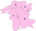
Map showing the districts of Worcestershire.
See also
 In Spanish: Worcestershire para niños
