
Worcestershire Beacon facts for kids
Quick facts for kids Worcestershire Beacon |
|
|---|---|
Worcestershire Beacon from North Hill
|
|
| Highest point | |
| Elevation | 425 m (1,394 ft) |
| Prominence | c. 337 metres (1,106 ft) |
| Parent peak | Hergest Ridge |
| Listing | Marilyn, Hardy, County Top |
| Geography | |

Worcestershire Beacon
Location in Worcestershire
|
|
| OS grid | SO768452 |
| Topo map | OS Landranger 150 |
| Geology | |
| Age of rock | Pre-Cambrian |
| Mountain type | Igneous, Metamorphic |
| Climbing | |
| Easiest route | Hiking |
Worcestershire Beacon, also known as Worcester Beacon or just The Beacon, is a famous hill in England. It stands 425 metres (1,394 ft) tall, making it the highest point in the Malvern Hills. This range of hills stretches about 13 kilometres (8.1 mi) from north to south.
The Beacon is located entirely within Worcestershire, even though the Malvern Hills run along the border with Herefordshire. Many people love to visit the Malvern Hills for walking. There are lots of easy paths that cross the area. The Countryside Agency has even called this beautiful place an Area of Outstanding Natural Beauty.
Contents
Why is it Called The Beacon?
The name Beacon comes from how the hill was used long ago. People would light fires on its top to send signals. Imagine a giant chain of warning fires!
One famous story about this is from 1588. That's when the Spanish Armada tried to invade England. Fires were lit on hills like Worcestershire Beacon to warn everyone. The poet Lord Macaulay wrote about this in his poem Armada:
And on, and on, without a pause, untired they bounded still
Till streamed in crimson on the wind the Wrekin’s crest of light.
All night from tower to tower they sprang; they sprang from hill to hill
Till the proud Peak unfurled the flag o’er Darwin’s rocky dales
Till like volcanoes flared to heaven the stormy hills of Wales,
Till twelve fair counties saw the blaze on Malvern’s lonely height,
Exploring the Beacon's Location
The eastern side of the hill is very steep. It starts right behind Bellevue Terrace, a main shopping street in Great Malvern. From there, you can walk to the top in about 35-40 minutes. You can go past St Ann's Well or through Happy Valley.
You can also reach the top from the western side. There's a short, steep climb from Jubilee Drive. Or, you can take a more relaxed walk along the top of the ridge. This path starts from a car park near the Wyche Cutting, which is about a mile south of the town centre.
Amazing Views from the Top
From the top of the Beacon, you can see for miles and miles! On a clear day, you might spot the Lickey Hills near Redditch or The Wrekin. You can even see past Birmingham to Cannock Chase.
Much of Herefordshire and Gloucestershire are visible too. You can see the mountains along the Welsh border and the Shropshire Hills. The valleys of the Severn and Avon stretch out below. Beyond them are the Cotswold Hills.
It's said you can see parts of thirteen different counties from here. You might even spot the Bristol Channel and the cathedrals of Worcester, Gloucester, and Hereford. The next highest point of land directly east of Worcestershire Beacon is on the western slope of the Ural Mountains!
What the Beacon is Made Of
The Malvern Hills are mostly made of igneous and metamorphic rocks. These rocks are very old, about 600 million years old, from the late Precambrian period.
The Beacon is part of a special area that allows the mineral springs and wells of the famous Malvern water to rise to the surface. This water is bottled and sold all over the world! These springs helped Malvern grow from a small village into a busy spa town in the early 1800s. Over millions of years, erosion and glaciers have shaped the Beacon and its nearby peaks. This is why they have their smooth, rounded look.
A Look Back in Time: Beacon's History

The hill seems to mark the northern end of the Shire Ditch. This ditch, also called Red Earl's Dyke, runs along the ridge of the hills. It was made in 1287 by Gilbert de Clare, the Earl of Gloucester. He built it after a disagreement about land borders with Thomas de Cantilupe, the Bishop of Hereford.
Some recent studies suggest the Shire Ditch might be even older. It could have started as a very old pathway from Worcestershire Beacon to Midsummer Hillfort.
Ancient Burials and Finds
The Beacon is also the site of two Bronze Age burials. In 1849, two pots filled with bones and ashes were found. A soldier named Private Harkiss found them while working for the Ordnance Survey. A local expert, Edwin Lees, wrote about these finds. The remains were from the Middle Bronze Age and are now kept in the British Museum.
Beacon Fires for Celebrations
As we learned, Worcestershire Beacon has often been used for signal fires. Besides the Spanish Armada warning in 1588, beacon fires were lit for many national celebrations. These included:
- The end of the Crimean War (1856)
- The marriage of the Prince and Princess of Wales (1863)
- Queen Victoria's Golden Jubilee (1887)
- Queen Victoria's Diamond Jubilee (1897)
- The coronation of King George V (1911)
- The Coronation of Queen Elizabeth II (1953)
In more recent times, fires have been lit for special events like the millennium night on December 31, 1999. A big fire was lit as part of a network of hill-top beacons across the country. Beacon fires were also lit on the Worcestershire Beacon for Queen Elizabeth II's Golden Jubilee in 2002 and her Diamond Jubilee in 2012.
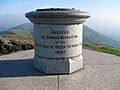
The Toposcope
At the very top of the Beacon, there's a special viewing device called a toposcope. It helps you identify all the hills you can see on a clear day. This toposcope was designed by a Malvern architect named Arthur Troyte Griffith. He was a friend of the famous composer Sir Edward Elgar. The toposcope was put up in 1897 to celebrate Queen Victoria's Diamond Jubilee.
Sadly, it was stolen in 2000, but the Malvern Hills Conservators replaced it that same year. The original one was returned in 2001.
Beacon's Role in Modern Times
During World War II, the Beacon was used as a lookout point. People watched for air raids heading towards Birmingham and Coventry. In the later part of the 1900s, the BBC often used the Beacon. They set up a transmitter relay van there to cover horse racing and sports events in Worcester.
Beacon Cafe Story
For many years, there was a cafe at the summit of the Beacon. But in 1989, it was destroyed by fire. The Malvern Hills Acts are special laws that say no new buildings should be put up on the land managed by the Conservators. So, when the cafe burned down, the Conservators wanted to rebuild it. However, they were told they might be breaking the law because the original cafe was on common land.
They tried to get permission to rebuild by adding a special section to a new Malvern Hills Bill in Parliament. But a group of five members from the House of Lords visited the hills. They decided there were enough other places to eat nearby, like the St Ann's Well cafe. So, they said no to rebuilding the cafe on the summit.
The Beacon in Pop Culture
Television Appearances
The West of England Quarry, which is on Worcestershire Beacon, was used as a filming location for the TV show Doctor Who. It appeared in the story called The Krotons, which starred Patrick Troughton as the Doctor. This episode was shown in four parts from December 1968 to January 1969.
Images for kids
-
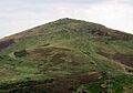
Worcestershire Beacon from North Hill
-
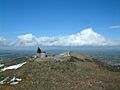
Toposcope on Worcestershire Beacon, with North Hill beyond
-
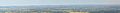
Panorama looking towards Cheltenham and Gloucester from summit
-
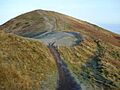
The Shire Ditch forms a shallow trough just to the right of the ridge all the way to the top of the Beacon
-
Diamond Jubilee Toposcope. Designed by Arthur Troyte Griffith and erected to commemorate Queen Victoria's Diamond Jubilee in 1897
