
River Avon, Warwickshire facts for kids
Quick facts for kids River Avon |
|
|---|---|

The River Avon by the Royal Shakespeare
Theatre in Stratford-upon-Avon |
|
.png)
Path of the Avon ([1])
|
|
| Country | England |
| Counties | Northamptonshire, Leicestershire, Warwickshire, Worcestershire, Gloucestershire |
| Towns | Rugby, Warwick, Stratford-upon-Avon, Evesham, Tewkesbury |
| Physical characteristics | |
| Main source | Naseby, Northamptonshire 52°23′51″N 0°59′19″W / 52.3975°N 0.9887°W |
| River mouth | Confluence with the River Severn, Tewkesbury 51°59′47″N 2°09′48″W / 51.9964°N 2.1634°W |
| Length | 137 km (85 mi) |
| Discharge (location 2) |
|
| Basin features | |
| River system | Severn |
| Basin size | 2,670 km2 (1,030 sq mi) |
| Tributaries | |
| Progression : Avon—Severn—Bristol Channel—Celtic Sea | |
The River Avon is a river in central England. It flows mostly southwest and is a main branch of the River Severn. It is sometimes called the Warwickshire Avon or Shakespeare's Avon. This helps people tell it apart from other rivers with the same name in the United Kingdom.
The river starts in Northamptonshire. It then flows through or next to the counties of Leicestershire, Warwickshire, Worcestershire, and Gloucestershire. It passes near the Cotswolds area. Important towns along its path include Rugby, Warwick, Stratford-upon-Avon, Evesham, and Tewkesbury. At Tewkesbury, it joins the River Severn.
People have used the River Avon for travel by boat for a long time. In 1635, work began to make it easier for boats to use. Locks and weirs were built, allowing boats to reach Stratford. The upper part of the river was hard to navigate and often flooded. It stopped being used for boats in 1877. The lower part kept going, but by 1945, only a small section was usable.
Starting in 1950, people worked to restore the lower river. This part was finished in 1962. The upper river was a bigger challenge because many of its old locks were gone. Work on the upper river began in 1965. Volunteers helped build nine new locks. This huge project was completed in 1974. Queen Elizabeth The Queen Mother officially opened it.
The Avon connects to the Stratford-upon-Avon Canal in Stratford. Today, it is mainly used by boats for fun. There are ideas to make the river navigable even further. This would connect it to the Grand Union Canal near Warwick or Leamington Spa.
Contents
What's in a Name?

The name "Avon" comes from an old British word, abona. This word simply means "river". You can still see this word in modern Welsh as afon and in Breton as avon, both meaning "river".
Because "Avon" means "river," the name "River Avon" actually means "River River." This is a type of place name where the meaning is repeated.
River's Journey
The source of the River Avon is a spring. It is located near the village of Naseby in Northamptonshire. For its first few miles, it forms the border between Northamptonshire and Leicestershire. Here, a dam created Stanford Reservoir.
The river then enters Warwickshire near Dow Bridge on Watling Street. It flows generally towards the west and southwest. It passes through towns and villages like Rugby, Wolston, Warwick, Stratford-upon-Avon, Evesham, and Pershore. Finally, it joins the River Severn at Tewkesbury.
The River Avon is about 85 miles (137 km) long. Its basin, the area of land that drains into it, covers about 1,032 square miles (2,670 km2). Many smaller rivers flow into the Avon. These include the Rivers Swift, Leam, Stour, Sowe, Arrow, and Isbourne.
A long walking path follows the river. It goes from its source all the way to the River Severn at Tewkesbury. This path is called Shakespeare's Avon Way. It is 88 miles (142 km) long. It uses existing paths to stay as close to the river as possible.
Ancient History of the River
Before the last Ice Age, about 50,000 years ago, the River Avon was much smaller. It used to flow north into the River Trent. During the Wolstonian Ice Age, ice sheets moved into the Midlands. These ice sheets blocked the Avon's path to the Trent.
The water became trapped by the glacier to the north, east, and west. The Cotswolds hills blocked it to the south. This led to the formation of a huge glacial lake, called Lake Harrison. At its biggest, this lake covered all of Warwickshire. It was more than 200 feet (60 m) deep.
About 10,000 years later, the glacier melted and moved back. The trapped water then cut a new path through the land. This new path flowed to the southwest, creating the river's route we see today.
Boating on the Avon
The River Avon is navigable from Alveston weir, which is 2 miles (3.2 km) upstream of Stratford-upon-Avon, down to Tewkesbury. This means boats can use this part of the river. This was made possible by building locks and weirs.
The Stratford-upon-Avon Canal connects to the Avon. This connection is through a lock in front of the Royal Shakespeare Theatre in Stratford-upon-Avon. Boats of a certain size can use the river. From Tewkesbury to Evesham, boats can be up to 70 ft (21 m) long. They can be 13 ft 6 in (4.1 m) wide and 10 ft (3.0 m) high. Their depth in the water (draught) can be up to 4 ft (1.2 m).
Above Evesham, the river is a bit narrower. Boats here are limited to 12 ft 6 in (3.8 m) wide. Their draught can be up to 3 ft (0.9 m).
Two special chain ferries cross the river. These are for pedestrians and are operated by hand. You can find them at the Hampton Ferry in Evesham and the Stratford-upon-Avon Ferry in Stratford-upon-Avon.
Today, the river is mostly used for fun and leisure. There are places to moor boats overnight in many towns. These include Stratford-upon-Avon, Evesham, and Pershore. Boat repair yards are also available in several locations.
The River Avon is part of the Avon Ring. This is a circular boating route that is 109 miles (175 km) long. It includes 129 locks. From Tewkesbury, it follows the River Severn. It then goes along the Worcester and Birmingham Canal and the Stratford-upon-Avon Canal. Finally, it returns to the Avon at Stratford-upon-Avon.


In 1635, King Charles I allowed work to begin on the Avon. This was to make it easier for boats to travel. William Sandys was given the job. He bought some mills on the river. He also built special locks with two gates. These locks helped boats pass without losing too much water. By 1641, boats could reach within 4 miles (6 km) of Warwick.
After some time, the river's use declined. But in 1662, new laws confirmed the right to navigate the river. More improvements were made from 1664 by a group led by Andrew Yarranton. They built three "navigation weirs." These were like simple locks that helped boats over shallow areas. Once this work was done, barges carrying 30 tonnes could reach Stratford.
In 1717, the river's navigation was officially split into two parts: the Upper Avon and the Lower Avon. Evesham was the dividing point. In 1758, George Perrott leased the Lower Avon. He spent over £4,000 to improve the locks and weirs. This allowed 40-ton barges to use the river by 1768.
Later, the Stratford-upon-Avon Canal was built. This caused problems for the Lower Avon. The canal competed for boat traffic. The Lower Avon was then leased to the Worcester and Birmingham Canal company from 1830 to 1851.

Meanwhile, the Upper Avon Navigation got worse. It was owned by relatives of Lord Windsor. In 1813, William James bought all the shares in the Upper Avon company. He convinced the Stratford Canal owners to connect their canal to the river at Stratford. This connection opened in 1816. James spent money repairing the locks but went bankrupt. The navigation was then taken over by seven men. They improved the river by dredging and building new locks.
However, there was still little traffic. The Upper Avon was leased to the Stratford Canal from 1842, but the lease was not renewed. When the railway arrived in Stratford, it sealed the river's fate. The railway company eventually stopped maintaining the river in 1875. A ruling in 1877 said they didn't have to.
The Lower Avon Navigation never completely stopped being used. The Worcester and Birmingham Canal renewed their lease in 1851. But a new railway link in 1864 greatly reduced traffic. By the end of World War II, only one barge used the section between Tewkesbury and Pershore. The river above Pershore became unusable.
Bringing the River Back to Life
Efforts to make the river navigable again began in 1949. An article in the Evesham Journal talked about the river's history and decline. Robert Aickman suggested the river could be restored. The Lower Avon Navigation Trust Ltd (LANT) was formed in 1950.
By 1952, LANT had raised over £4,000. The Royal Engineers helped rebuild Chadbury Lock as a training exercise. This helped raise public awareness and more funds. By 1962, LANT had raised over £50,000. The seven locks from Tewkesbury to Evesham were repaired. This reopened the Lower Avon. Mrs. Barwell formally opened the waterway in June 1962.
An unknown person offered £80,000 in 1963 to restore the Upper Avon. A donation of £5,000 helped rebuild Evesham lock. It opened on June 11, 1964. The National Trust had restored the Stratford-upon-Avon Canal. Queen Elizabeth The Queen Mother opened it a month later. Her involvement made the public very interested.
The Upper Avon Navigation Trust Ltd (UANT) was formed in 1965. They aimed to rebuild the Upper Avon, which was in much worse shape. David Hutchings, who had just finished the Stratford Canal restoration, led the project. Work began on July 19, 1966.

Building new locks and weirs, mostly with volunteers, was a new idea. The Severn River Authority agreed to the work. A special law, the Upper Avon Navigation Act 1972, made it official. More money came from a national fund.
Phase one of the restoration, from Evesham to Bidford Bridge, opened on June 12, 1971. The total cost was estimated at £250,000. All of this was raised by public donations, except for a £25,000 grant from the government. The project involved building nine new locks. It reopened 17-mile (27 km) of river that had not been used for over 100 years. The project was finished on June 1, 1974. Queen Elizabeth the Queen Mother returned to Stratford to declare it open. This was the biggest project of its kind at that time.
Future Plans for the River
There have been ideas to extend the river's navigation. This would go upstream from Alveston to connect with the Grand Union Canal. This connection could be at Warwick or Leamington Spa. The Severn Trent Water Authority first looked into this in 1974.
This plan would open up a part of the river that has never been navigable before. However, not everyone agrees with the idea. Landowners at Warwick Castle and Charlecote Park have tried to claim the river as private property. But old records from 1636 state that the river was free for all to use up to Coventry. Even with much local support, some people still oppose the plan.
River's Modern Use

Commercial traffic returned to the Avon in May 2010. This was part of a project to build flood defenses in Pershore. The town had suffered damage from flooding in 2007. Clay banks are being built using material from Birlingham, further downstream.
About 15,000 tonnes of clay are being moved by barge. This saves about 3,000 lorry trips between the two sites. At Birlingham, the excavation will create a wetland reserve for wildlife. This will include 32 acres (13 ha) of wet grassland and 5 acres (2 ha) of open water. The Worcestershire Wildlife Trust is working with the landowner on this project. The new reserve will be called the John Bennett Reserve.
Images for kids
-
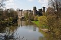
The Avon alongside Warwick Castle

See also
 In Spanish: Río Avon (Warwickshire) para niños
