
Stratford-upon-Avon Canal facts for kids
Quick facts for kids Stratford-upon-Avon Canal |
|
|---|---|

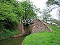
A stretch of the canal in Stratford
|
|
| Specifications | |
| Maximum boat length | 70 ft 0 in (21.34 m) |
| Maximum boat beam | 7 ft 0 in (2.13 m) |
| Locks | 56 |
| Status | Navigable |
| Navigation authority | Canal and River Trust |
| History | |
| Original owner | Stratford-upon-Avon Canal Company |
| Principal engineer | William Clowes |
| Date of act | 1793 |
| Date of first use | 1800 |
| Date completed | 1816 |
| Date closed | 1939 |
| Date restored | 1964 |
| Geography | |
| Start point | Kings Norton |
| End point | Stratford |
| Connects to | Worcester and Birmingham Canal, Grand Union Canal, River Avon |
The Stratford-upon-Avon Canal is a special waterway in the middle of England. It was built a long time ago, between 1793 and 1816. This canal is about 41 kilometers (25.5 miles) long and has two main parts. These parts meet at a place called Kingswood Junction, which also connects to another canal, the Grand Union Canal.
After a railway company bought the canal in 1856, it slowly became less used. By 1945, the southern part was almost impossible to use for boats. The northern part was not much better. But people worked hard to save it! In 1947, a new group called the Inland Waterways Association fought to keep the northern part open. They even made the Great Western Railway company lift a bridge so boats could pass. These actions stopped the northern part from closing completely.
The southern part of the canal was fixed up by the National Trust between 1961 and 1964. This happened after a plan to close it was stopped. When the canal was ready again, Queen Elizabeth The Queen Mother officially reopened it. Later, in 1988, another group called British Waterways took over looking after the canal.
Contents
Exploring the Canal's Path
The Stratford-upon-Avon Canal links the Worcester and Birmingham Canal at Kings Norton to the River Avon at Stratford-upon-Avon in Warwickshire. It has two sections, separated by a junction that connects it to the Grand Union Canal.
Northern Section: From Kings Norton to Lapworth
The northern part starts in Birmingham and goes for about 17.4 kilometers (10.8 miles) to Lapworth. This first part is flat, following what's called the Birmingham Level, which is about 138 meters (453 feet) high. Then, the canal goes downhill quickly through a series of 18 locks called the Lapworth flight. These locks help boats move up or down hills.
At the junction, there are two locks side-by-side that lead to the Grand Union Canal. A small channel connects the bottom of both locks. This junction is almost exactly in the middle of the whole canal.
Southern Section: From Lapworth to Stratford
The southern part continues going downhill with the last seven Lapworth locks. It passes under the M40 motorway just before the last lock. The locks are close together at first. Then, there's a long, flat section of about 9.7 kilometers (6 miles) with only one lock in the middle. This flat part has two of the canal's three special iron aqueducts.
The easy journey is interrupted by the Wilmcote flight, which has eleven locks in just over 1.6 kilometers (1 mile). Soon after these locks, the canal reaches Stratford-upon-Avon.
Locks and Water Supply
Along its 41-kilometer (25.5-mile) path, the canal has 54 narrow locks. Near King's Norton Junction, there's an old stop lock that isn't used anymore. It used to stop the canal from taking water from the Worcester and Birmingham Canal. This lock is special because it has two wooden gates that move up and down like guillotine blades.
A larger lock connects the end of the canal (Bancroft Basin) to the River Avon.
The canal gets its water from the Earlswood Lakes in Earlswood. These three lakes were built between 1821 and 1822. They can hold a huge amount of water, about 950 million liters (210 million gallons). The lakes are called Terry's, Engine, and Windmill Pool. Until 1936, a special engine pumped water into the canal. You can still see the building where the engine was.
Special Features of the Canal
The Stratford-upon-Avon Canal has many interesting and unique features along its route.
Northern End Highlights
- King's Norton Stop Lock: At the very start of the canal, near Kings Norton Junction, you'll find a very unusual lock. It's the only one on a canal with "guillotine gates" that move up and down.
- Brandwood Tunnel: About 1.2 kilometers (3/4 mile) from the start is the only tunnel on the canal, at Brandwood. It's 322 meters (352 yards) long. Like many old canal tunnels, it doesn't have a path for horses. Horses had to walk over the hill, and boats were pulled through by people using a handrail inside the tunnel. You can still see parts of this handrail!
- Major's Green Aqueduct: Near Shirley, a brick bridge called Major's Green Aqueduct carries the canal 10 meters (33 feet) above Aqueduct Road and the River Cole.
- Shirley Draw Bridge: Just a bit further south is the Shirley Draw Bridge. This bridge can be opened using electricity to let boats pass. It's usually closed for road traffic. The northern section also has other bridges that can be opened by hand, like a swing bridge, a lift bridge, and another drawbridge.
Southern Section Highlights

- Barrel-Roofed Cottages: South of Kingswood Junction, you can see unique lock keeper's cottages with rounded, barrel-shaped roofs. Most have been changed with new additions, but two at locks 28 and 31 still look much like they did originally. They don't even have electricity or running water!
- Split Bridges: Many of the bridges south of Kingswood Junction are "split bridges." These are made of cast iron and have a gap in the middle. This gap allowed the tow rope of a horse-drawn boat to pass through without needing to unhitch the horse.

- Iron Aqueducts: The southern part of the canal crosses three special aqueducts made of cast iron. What's unusual is that the towpaths (paths for horses) are at the same level as the canal bottom.
- Yarningale Aqueduct: The first aqueduct when traveling south from Kingswood Junction is the Yarningale Aqueduct. It carries the canal over a small stream near Preston Bagot, Warwickshire. This iron aqueduct was built in 1834 after the first wooden one was washed away by a flood.
- Wootton Wawen Aqueduct: The second is the Wootton Wawen Aqueduct, near Wootton Wawen. Here, the canal crosses over the main A3400 road.

-
- Edstone Aqueduct: The third is the Edstone Aqueduct, also known as Bearley. At 145 meters (475 feet), it's the longest aqueduct in England! It crosses a small road, a railway line, and an old railway track. Long ago, there was even a pipe from the canal that allowed steam trains to get water for their engines.
The Canal's Journey Through Time
The idea for the Stratford-upon-Avon Canal came about because people wanted a way to move coal from the Dudley Canal and the Stourbridge Canal to places like Oxford and London. They didn't want to rely on the Birmingham canals, which were sometimes difficult to deal with.
Building the Canal: Early Years

On March 28, 1793, a special law was passed to build the canal. It would go from a connection with the Worcester and Birmingham Canal in Kings Norton to Stratford-upon-Avon. The company building the canal could raise money by selling shares.
Josiah Clowes was hired as the engineer, and building started in November 1793 at the Kings Norton end. He was a very busy engineer, working on many canals at once. He passed away in December 1794, but work continued. The main part of the canal reached Hockley Heath in May 1796. At this point, they ran out of money, and building stopped.
In 1799, work started again with a new engineer, Samuel Porter. He continued building until Kingswood Junction was officially opened on May 24, 1802. After that, building stopped again.
Completing the Southern Section
Building didn't start again until 1812, led by William James. He was a businessman from Stratford who owned shares in the canal company. He wanted to create a full route between the River Severn and the Midlands. So, in 1815, another law was passed to connect the canal to the River Avon at Stratford. It also allowed them to build reservoirs at Earlswood.
The canal finally reached Stratford in June 1816, and the connection to the River Avon was made. The total cost to build the canal was around £297,000.
However, the southern part of the canal didn't become as important as William James hoped. The Upper Avon River was too twisty and often flooded, making it hard to use reliably.
Decline and the Fight to Save the Canal


Over time, traffic on the canal slowly decreased. In 1845, the canal company agreed to sell the canal to a railway company. By 1856, the railway company took over. In 1863, the canal was owned by the Great Western Railway. As railways became more popular, fewer goods were carried on the canal.
By the late 1930s, the southern part of the canal was in bad shape and couldn't be used by boats. The northern part was also almost unused by 1939. A bridge at Lifford became faulty, and the railway company replaced it with a fixed bridge that was too low for boats to pass under.
A Turning Point: Restoration Efforts

In 1947, a man named Lord Methuen raised concerns about the canal in the House of Lords. He was told the bridge would be lifted if boats needed to pass. So, Tom Rolt from the Inland Waterways Association (IWA) announced he would try to pass under the bridge. Despite many difficulties, he reached the bridge, which had been lifted up. Robert Aickman, another IWA founder, made sure the newspapers reported the story. This helped save the northern part of the canal from being closed forever. In 1950, the problematic bridge was replaced with a working swing bridge.
By the 1950s, the southern part of the canal was unusable. Many locks didn't work, and some sections were dry. In 1958, the local council wanted to officially close the canal so they could replace a bridge without making it high enough for boats. But the Inland Waterways Association and local people fought against this. They even showed a dated ticket from canoeists who had recently used the canal, proving it was not completely unused.
In 1959, it was announced that the canal would stay open. In 1960, the National Trust took over the southern section. Work began in March 1961. The National Trust raised most of the money needed, and many volunteers helped with the restoration. Prisoners, the Army, and the RAF also helped.
By mid-1964, the canal was fully working again. Queen Elizabeth The Queen Mother officially reopened it on July 11, 1964. This restoration was a very important moment for saving waterways in Britain.
In 1986, the National Trust decided to hand control of the canal back to the British Waterways Board. This transfer happened on April 1, 1988, with money provided to keep the canal in good condition.
Images for kids
-
A split bridge spanning the canal near Turners Green. The towpath ran beside the bridge, rather than beneath it, and the towrope was passed through the slot.

| Point | Coordinates (Links to map resources) |
OS Grid Ref | Notes |
|---|---|---|---|
| Jn with Worcester and Birmingham Canal | 52°24′44″N 1°55′20″W / 52.4123°N 1.9223°W | SP053793 | |
| Brandwood Tunnel | 52°24′48″N 1°54′15″W / 52.4132°N 1.9042°W | SP066794 | |
| Earlswood Lakes feeder | 52°22′24″N 1°49′57″W / 52.3734°N 1.8326°W | SP114750 | |
| M42 Motorway bridge | 52°21′45″N 1°48′16″W / 52.3626°N 1.8044°W | SP134738 | |
| Lapworth flight lock 2 | 52°20′32″N 1°45′34″W / 52.3422°N 1.7595°W | SP164715 | |
| Kingswood Jn with Grand Union Canal | 52°20′06″N 1°43′38″W / 52.3350°N 1.7271°W | SP186708 | |
| Lapworth flight lock 27 | 52°19′23″N 1°43′37″W / 52.3230°N 1.7269°W | SP187694 | |
| Yarningale aqueduct | 52°17′43″N 1°43′54″W / 52.2954°N 1.7318°W | SP183663 | |
| Wootton Wawen aqueduct | 52°15′53″N 1°46′09″W / 52.2647°N 1.7693°W | SP158629 | |
| Edstone aqueduct | 52°14′47″N 1°45′51″W / 52.2465°N 1.7642°W | SP161609 | |
| Wilmcote flight lock 40 | 52°12′57″N 1°45′07″W / 52.2158°N 1.7519°W | SP170575 | |
| Wilmcote flight lock 50 | 52°12′26″N 1°44′19″W / 52.2072°N 1.7387°W | SP179565 | |
| Jn with River Avon | 52°11′29″N 1°42′08″W / 52.1915°N 1.7022°W | SP204548 |
See also
 In Spanish: Canal de Stratford-upon-Avon para niños
