
Kings Norton Junction facts for kids
Quick facts for kids Kings Norton Junction |
|
|---|---|

The roving bridge crosses the Worcester and Birmingham Canal, while the Stratford-upon-Avon Canal starts at the top right.
|
|
| Specifications | |
| Status | Open |
| Navigation authority | British Waterways |
| History | |
| Date completed | 1807 |


Kings Norton Junction is a special place where two important waterways meet. It's where the Stratford-upon-Avon Canal ends and joins the Worcester and Birmingham Canal. You can find this junction in Kings Norton, a part of Birmingham, England. Think of it like a crossroads for boats!
Contents
Building the Canals
Canals were like the motorways of their time. They helped transport goods across the country. Building them was a huge and difficult job!
The Worcester and Birmingham Canal
The idea for the Worcester and Birmingham Canal was approved by Parliament in 1791. Not everyone was happy about it at first. Some existing canal companies worried it would take away their business.
Workers started building the canal south from Birmingham. They had to dig a long tunnel called the Wast Hill Tunnel, which is about 2,500 metres (2,726 yards) long! By 1807, boats could travel as far as Tardebigge. The canal was finally finished in 1815, connecting Birmingham all the way to the River Severn at Diglis Basin.
The Stratford-upon-Avon Canal
The Stratford-upon-Avon Canal was approved in 1793. The people of Stratford wanted to make sure their town would benefit from the new canal network.
Construction began right here at Kings Norton Junction. This canal was important because it could connect to other canals, like the Dudley Canal, which led to coal mining areas. This meant coal could be easily transported. Building was slow for a while because there wasn't enough money. But by 1803, the canal reached Kingswood Junction, where it linked to another important waterway. This connection brought a lot more boat traffic through Kings Norton Junction. The last part of the canal, leading to Stratford, was finished between 1812 and 1815.
A Canal's Comeback
Even though parts of the Stratford-upon-Avon Canal were closed later on, the northern section, near Kings Norton Junction, never officially closed. However, not many boats used it after 1939. A bridge near the stop lock, called Lifford Bridge, couldn't even swing open after 1942.
This led to an exciting event in 1947. A group called the Inland Waterways Association wanted to bring attention to the canals. One of their members, Tom Rolt, announced he would travel through the junction and along the canal. The railway company that owned the bridge had to lift it up so his boat could pass! This event was reported in many newspapers and helped show people how important it was to keep the canals open.
What You Can See at the Junction
Kings Norton Junction is a fascinating place with lots of history.
Toll House and Fees
Right next to the canal, you'll see the Worcester and Birmingham toll house. This building was used to collect money from boats using the canal. On its wall, there's a copy of the toll fees from 1793. Imagine paying less than a penny (½d) per ton for lime, but more for food!
The Guillotine Stop Lock
Near the junction is the Lifford Lane guillotine stop lock. This lock is quite unique! Instead of swinging gates, it has two wooden gates that move up and down vertically in metal frames, like a guillotine.
Originally, this lock kept the water from the two different canal companies separate. But since 1948, when the canals became managed by British Waterways, both gates are kept open. This historic structure is a "grade II* listed" building, meaning it's very important and protected. Its strong metal frames and counterweights are still the originals!
Historic Buildings and Bridges
At the junction, there's a historic house built in 1802. It's made of red brick and has fancy columns around the front door. It's much bigger than a typical lock-keeper's cottage.
Just north of the junction, you'll find the junction bridge. This bridge carries the towpath (the path where horses used to pull boats) over the Worcester and Birmingham Canal to reach the Stratford-upon-Avon Canal. It's also a listed building, showing its historical importance.
Canal Routes from the Junction
From Kings Norton Junction, the Worcester and Birmingham Canal stretches north for about 8.8 kilometres (5.5 miles) without any locks, until it reaches another junction in Birmingham.
To the south, the Worcester and Birmingham Canal also stays level for about 13.8 kilometres (8.6 miles). It passes through more tunnels before reaching the top of the famous Tardebigge flight, which has thirty locks that lower the canal a great distance.
The Stratford-upon-Avon Canal starts by heading east from the junction, then turns southeast. It stays level for about 17.4 kilometres (10.8 miles). After that, 19 locks lower the canal down to Kingswood Junction, where it meets the Grand Union Canal.
Images for kids
-
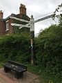
Kings Norton Junction finger post

