
Cotswolds facts for kids
Quick facts for kids Cotswolds |
|
|---|---|

Castle Combe, a Cotswolds village with buildings made of Cotswold stone
|
|

Location of the Cotswolds within England
|
|
| Location | England |
| Area | 2,038 km2 (787 sq mi) |
| Established | 1966 |
| Named for | cot + wold, ’sheep enclosure in rolling hillsides’ |
The Cotswolds is a beautiful area in south-central England. It's known for its rolling hills that gently rise from the flat meadows near the River Thames. These hills then become a steeper slope, or escarpment, looking over the Severn Valley.
The area is special because of its Jurassic limestone rock. This rock creates a rare type of grassland and is also used to make the golden-coloured Cotswold stone. You'll see this stone everywhere! It's used to build the pretty villages, historic towns, and grand homes that make the Cotswolds so unique.
In 1966, the Cotswolds was named an Area of Outstanding Natural Beauty (AONB). It covers about 2,038 square kilometres (787 square miles). This makes it the third largest protected landscape in England, after the Lake District and Yorkshire Dales national parks. It's also the biggest AONB. The Cotswolds stretches for about 40 kilometres (25 miles) across and 145 kilometres (90 miles) long. It goes from south of Stratford-upon-Avon down to south of Bath. The area spreads across several counties, mainly Gloucestershire and Oxfordshire, with parts in Wiltshire, Somerset, Worcestershire, and Warwickshire. The highest point is Cleeve Hill, which is 330 metres (1,083 feet) high.
The name Cotswold also belongs to a local government area called the Cotswold District. This district is in Gloucestershire, and its main town is Cirencester. The larger Cotswolds area, including the AONB, covers almost 2,072 square kilometres (800 square miles) and has a population of about 139,000 people.
Contents
History of the Cotswolds
People have lived in the Cotswolds for a very long time. We know this because ancient people from the Neolithic period (New Stone Age) left behind burial chambers. There are also remains of forts from the Bronze and Iron Ages. Later, the Romans built fancy villas, like the one at Chedworth, and important towns such as Gloucester. They also built roads, including the famous Fosse Way.
During the Middle Ages, the Cotswolds became very rich. This was thanks to a special type of sheep called the Cotswold Lion. Their wool was highly valued and traded with other countries. Much of the money earned from wool was used to build the beautiful churches you can still see today. These are often called "wool churches." Today, the Cotswolds is still a popular place, and many people from cities like London buy second homes or retire here.
The name "Cotswold" is often thought to mean "sheep enclosure in rolling hills." The word wold means hills. However, experts believe the name comes from an older form, Codesuualt, meaning "Cod's high open land." "Cod" might have been an Old English personal name. Some even think it could come from an ancient Celtic goddess named "Cuda" who was worshipped in this area.
Geography and Villages

The Cotswolds stretches from southwest to northeast across six counties. The northern and western edges have steep slopes, called the Cotswold escarpment or Cotswold Edge. This steep edge formed because the limestone rock layer was pushed up and tilted. The gentler slope, called the dip slope, is to the southeast.
The area is famous for its charming small towns and villages. They are all built from the local Cotswold stone, which is a yellow limestone. This stone is full of fossils, especially fossilised sea urchins! Some well-known Cotswold towns include Bourton-on-the-Water, Broadway, Burford, Chipping Norton, Moreton-in-Marsh, Stow-on-the-Wold, and Stroud. Larger towns like Bath, Cheltenham, Cirencester, and Gloucester are either next to or surrounded by the Cotswolds.
Chipping Campden is a special town. It was home to the Arts and Crafts movement in the late 1800s and early 1900s, started by William Morris. Chipping Campden also hosts the yearly Cotswold Olimpick Games, a fun event with sports and games that started way back in the 1600s!
Cotswold Stone

Cotswold stone is a type of yellow limestone from the Jurassic period. It's full of fossils, especially fossilised sea urchins. When buildings made of this stone get older, their colour is often described as honey or golden. The stone's colour changes a bit from north to south. In the north, it's honey-coloured, like in Stanton and Broadway. In the middle and south, it's more golden, seen in Dursley and Cirencester. Near Bath, it can even look pearly white.
You can find this rock in small quarries across the Cotswolds. Sometimes, villages built with different stones, like the red ironstone in Hook Norton, are also called Cotswold villages. However, they don't have the famous golden Cotswold stone.
Area of Outstanding Natural Beauty

The Cotswolds was officially named an Area of Outstanding Natural Beauty (AONB) in 1966. Its size was updated in 1991 to 2,038 square kilometres (787 square miles). In 2000, the government confirmed that AONBs are just as important for their beautiful landscapes as National Parks.
The Cotswolds AONB is the largest in England and Wales. It stretches from parts of Warwickshire and Worcestershire, through Oxfordshire and Gloucestershire, and into Wiltshire and Bath. The Cotswolds Conservation Board works to protect and improve this special area. They get funding and help plan how the area is used.
The Cotswolds AONB is beautiful not just because of its villages, but also because of its rare limestone grasslands and old beech woodlands. These habitats are home to many plants and animals, some of which are very rare and protected by law. For example, Cleeve Hill is a great example of limestone grassland, and it's one of the few places where you can still find many Duke of Burgundy butterflies.
The Cotswolds is so important that it has five European Special Areas of Conservation, three National Nature Reserves, and over eighty Sites of Special Scientific Interest within its boundaries.
The Cotswold Voluntary Wardens Service started in 1968. Over 300 volunteers help look after the area. You can also explore the Cotswolds on the Cotswold Way, a walking path over 160 kilometres (100 miles) long. It mostly follows the edge of the Cotswold escarpment, offering amazing views over the Severn Valley.
Places to Visit

There are many interesting places to visit in the Cotswolds. Sudeley Castle in Winchcombe has a beautiful "Secret Garden." The castle itself was built in the 1400s. Nearby is the spa town of Cheltenham, famous for its old Georgian buildings.
Other historic sites include Beverston Castle, built in 1229, and Calcot Manor, which started as a barn around 1300 AD. Tetbury Market House, built in 1655, shows how important Tetbury was for the wool trade. Chavenage House is an Elizabethan manor house near Tetbury.
Don't miss Chedworth Roman Villa, where you can see ancient Roman buildings and mosaics. It's located near the Roman road called the Fosse Way. The ruins of Cirencester Abbey and Malmesbury Abbey are also very old and interesting.
For unique houses, there's Quarwood, a Victorian Gothic house in Stow-on-the-Wold with large grounds. Woodchester Mansion is an unfinished Gothic mansion, and Newark Park is a Tudor country house with a large estate. Owlpen Manor is another beautiful Tudor manor house. Further north, Broadway Tower is a famous folly on a hill. To the south, Corsham Court is an English country house with gardens designed by Capability Brown.
Getting Around

The Cotswolds is located between three major motorways: the M5, M40, and M4 motorway. Several main roads cross the area, including the A46, A419, A417, A429, A44, and A40. Many of these roads follow ancient routes, some even built by the Romans.
Local bus services are available, but they might not run very often.
The River Thames starts in the Cotswolds. You can travel by boat on the Thames from Lechlade downstream towards Oxford. There were also canals like the Thames and Severn Canal that connected the Thames to the River Severn, but most of these are not used anymore.
Trains
The Cotswolds area is near two main train lines: the Bristol–Bath–London line in the south and the Bristol–Birmingham line in the west. The Cotswold Line also runs through the area from Oxford to Worcester. The Golden Valley line crosses the hills from Swindon to Gloucester.
You can catch mainline trains to big cities from stations like Bath, Swindon, Oxford, Cheltenham, and Worcester. There are also trains to London Paddington from smaller stations like Kemble, Kingham, Charlbury, and Moreton-in-Marsh.
For a fun trip, you can ride the Gloucestershire Warwickshire Railway. This is a special steam heritage railway that runs from Cheltenham Racecourse to Toddington and Broadway.
Cotswolds in Culture
The beautiful Cotswolds region has inspired many famous English composers. In the early 1900s, Herbert Howells and Ivor Gurney often walked together in the hills. Gurney encouraged Howells to use the landscape as inspiration for his music. Gerald Finzi also lived nearby.
Gustav Holst even named one of his symphonies The Cotswolds. The composer Ralph Vaughan Williams wrote an opera called "Hugh the Drover" which shows life in a Cotswold village and uses local folk songs. In 1988, Derek Bourgeois titled his 6th symphony "A Cotswold Symphony".
The film Better Things (2008) is set in a small Cotswold village. The fictional detective Agatha Raisin lives in a made-up Cotswolds village called Carsely. Many episodes of Agatha Christie's Poirot also take place in the Cotswolds.
Economy and Tourism

The main ways people earn money in the Cotswolds are through real estate, renting, business activities, manufacturing, and shops. About 44% of people work in these areas. Farming is also very important, with about 86% of the land used for it. Farmers grow crops like barley and wheat, and raise sheep, cows, and pigs.
According to a 2011 study, the biggest employer was shops and retail (15.8% of workers), followed by education (9.7%) and health care (9.3%). The number of people without jobs in the Cotswold District is very low, which is good news!
Tourism
Tourism is a huge part of the Cotswolds' economy. In 2016, visitors spent over £373 million on places to stay, £157 million on attractions, and about £100 million on travel just in the Cotswold District. For the wider Cotswolds area, tourism brought in about £1 billion in 2016 and created 200,000 jobs. About 38 million day trips were made to the Cotswolds that year.
Many travel guides suggest visiting Chipping Campden, Stow-on-the-Wold, Bourton-on-the-Water, Broadway, Bibury, and Stanton. These places can get very busy! For example, about 300,000 people visit Bourton-on-the-Water each year.
The area also has many public walking trails and footpaths that attract visitors. This includes the 150-kilometre (93-mile) Cotswold Way from Bath to Chipping Campden.
New Homes
In 2018, a plan was approved to build nearly 7,000 new homes by 2031. These homes will be built in towns like Cirencester, Bourton-on-the-Water, Fairford, and Moreton-in-Marsh. Money from these developments will help build new roads and other services for the growing population.
Images for kids
-
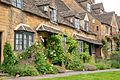
Broadway row houses of Cotswold stone
-
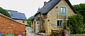
Some of the stone cottages feature thatched roofs, although slate is now more common (Stretton-On-Fosse)


See also
 In Spanish: Montes Cotswold para niños
