
Fosse Way facts for kids

The Fosse Way was a very important Roman road in Roman Britain. It was special because it didn't go near London. Instead, it stretched directly from the southwest coast to the middle of the east coast. This long road connected Exeter (which the Romans called Isca Dumnoniorum) in South West England to Lincoln (Lindum Colonia) in the East Midlands. Along the way, it passed through towns like Ilchester (Lindinis), Bath (Aquae Sulis), Cirencester (Corinium), and Leicester (Ratae Corieltauvorum).
The Fosse Way connected with other major Roman roads. It met Akeman Street and Ermin Way at Cirencester. It crossed Watling Street at a place called Venonis (now High Cross), south of Leicester. Finally, it joined Ermine Street in Lincoln.
Contents
What Does "Fosse" Mean?
The name Fosse comes from the Latin word fossa, which means 'ditch'. When the Romans invaded Britain in AD 43, the Fosse Way acted as the western edge of their control for many years. It's thought that the road might have started as a defensive ditch. This ditch could have later been filled in and turned into a road. Or, perhaps a defensive ditch ran right next to the road for some of its length.
A Very Straight Road
The Fosse Way is famous for being incredibly straight. From Lincoln to Ilchester in Somerset, the road covers about 182 miles (293 kilometers). What's amazing is that the road never goes more than six miles away from a perfectly straight line between these two points! This shows how skilled Roman engineers were.
Roman Place Names
You might notice many British towns have names ending in "-cester" or "-chester." These names come from the Latin word castra, which means 'military camp'. For example, Cirencester and Leicester were once Roman military camps. The word 'street' in road names also comes from the Latin word strata, meaning a paved road.
The Fosse Way Today
Even now, parts of the Fosse Way are still in use. Some sections are busy main roads, while others are quiet country paths. For instance, the A46 road between Lincoln and Leicester follows the Fosse Way. Between Bath and Ilchester, the A37 road uses the Fosse's route. And from Ilchester to Exeter, the A30 and A303 roads largely follow the old Roman path. The Roman engineers simply built the shortest possible route!
Images for kids
-
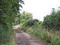
A part of the Fosse Way that is now a byway (a small road or track) north of the M4 motorway.

See also
 In Spanish: Fosse Way para niños
