Akeman Street facts for kids
Quick facts for kids
[[File:|175x70px|alt= shield]] Akeman Street |
|
|---|---|

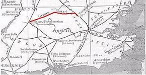
Roman roads in south east England with Akeman Street in red
|
|
| Route information | |
| Length | 117 km (73 mi) |
| Time period | Roman Britain |
| Major junctions | |
| From | Verulanium (St Albans) |
| To | Corinium Dobunnorum (Cirencester) |
| Location | |
| Counties: | Hertfordshire, Buckinghamshire, Oxfordshire, Gloucestershire |
| Road network | |
|
|

Akeman Street is an ancient Roman road in southern England. It stretches about 117 kilometers (73 miles) across what are now the counties of Hertfordshire and Gloucestershire. This historic road generally runs from east to west.
What is Akeman Street?
Akeman Street was a very important road built by the Romans. It connected two major Roman towns. These towns were Verulamium (near modern St Albans) and Corinium Dobunnorum (now Cirencester). Verulamium was linked to another big Roman road called Watling Street. Corinium Dobunnorum was connected to the Fosse Way.
How Was Akeman Street Built?
Historians believe that Akeman Street might have been an older track first. The Romans then improved it greatly. They added a hard surface and made it more organized. This helped them move soldiers, goods, and messages quickly across their territory.
Where Did Akeman Street Go?
The road passed through many places that are now towns and villages. These include Hemel Hempstead, Berkhamsted, and Tring. It also went through Aylesbury and Alchester. Alchester was a Roman town located outside modern Bicester. Other places along its path include Chesterton, Kirtlington, Ramsden, and Asthall.
How is Akeman Street Used Today?
Even today, parts of Akeman Street are still in use. For example, some sections of the A41 road follow the old Roman path. This is true between Berkhamsted and Bicester. A smaller road between Chesterton and Kirtlington also uses its route.
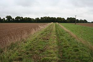
Other parts of Akeman Street are now public footpaths. This means people can walk along them. A good example is a 6-mile (10 km) stretch between Tackley and Stonesfield. This part is now part of the Oxfordshire Way, a popular walking trail.
What Does "Akeman" Mean?
The exact meaning of the name "Akeman Street" is not fully known. It is a very old name, dating back to the Early Middle Ages. Some people think "Akeman" comes from old Anglo-Saxon words. These words might have meant "oak-man."
Another idea connects the name to the city of Bath. The Anglo-Saxons called Bath Acemannesceastre. Acemannes might have come from the Roman name for Bath, which was Aquae Sulis. It is unclear how this name became linked to Akeman Street. One idea is that the name was first used for a very long road that started from Bath.
 | Delilah Pierce |
 | Gordon Parks |
 | Augusta Savage |
 | Charles Ethan Porter |

