
Hemel Hempstead facts for kids
Quick facts for kids Hemel Hempstead |
|
|---|---|
| Town | |
|
The old town centre
The new town centre
|
|

Hemel Hempstead
|
|
| Population | 95,961 (2021 Census) |
| OS grid reference | TL 056 071 |
| District |
|
| Shire county | |
| Region | |
| Country | England |
| Sovereign state | United Kingdom |
| Post town | HEMEL HEMPSTEAD |
| Postcode district | HP1, HP2, HP3 |
| Dialling code | 01442 |
| Police | Hertfordshire |
| Fire | Hertfordshire |
| Ambulance | East of England |
| EU Parliament | East of England |
| UK Parliament |
|
.jpg)
.jpg)
Hemel Hempstead (/ˌhɛməl ˈhɛmps[unsupported input]d/) is a busy town in the Dacorum area of Hertfordshire, England. It is about 24 miles (39 km) north-west of London. Other nearby towns include Watford, St Albans and Berkhamsted. In 2021, the town had a population of 95,961 people.
Hemel Hempstead has been around since at least the 8th century. It received its special town charter from King Henry VIII in 1539. However, it grew a lot after the Second World War. This was when it was chosen to be a "new town" to help house people from London.
Contents
- Exploring Hemel Hempstead's Past
- Hemel Hempstead's Location and Surroundings
- Neighbourhoods and Areas of Hemel Hempstead
- Businesses and Jobs in Hemel Hempstead
- Getting Around Hemel Hempstead
- Sports and Activities in Hemel Hempstead
- Schools in Hemel Hempstead
- How Hemel Hempstead is Governed
- Town Partnerships
- Interesting Features of Hemel Hempstead
- Major Events in Hemel Hempstead
- Famous People from Hemel Hempstead
- Hemel Hempstead in Film, TV, and Entertainment
- Local News and Radio
- Images for kids
- See also
Exploring Hemel Hempstead's Past
How Hemel Hempstead Got Its Name
In olden times, during the Anglo-Saxon period, this place was called Henamsted or Hean-Hempsted. By the time of William the Conqueror, it was known as Hemel-Amstede. The famous Domesday Book of 1086 calls it Hamelamestede. Later, it became Hamelhamsted or Hemlamstede.
The word -stead or -stede in Old English simply meant "place." It was like a spot for a building or a field. You can see this in other English place names like Hamstead.
One idea is that "Hemel" was added to tell it apart from nearby Berkhamsted. "Hemel" is like the German and Dutch word for 'heaven' or 'sky'. So, maybe Hemel Hempstead was a more open, less forested area. Berkhamsted, on the other hand, might have meant 'birch forest'.
Another idea is that "Hemel" came from "Haemele." This was the name of the area in the 8th century. It might have been the name of a landowner or meant "broken country."
Today, locals often just call the town "Hemel." But before the Second World War, people called it "Hempstead." Some people from Hemel Hempstead moved to the American colonies in the 1600s. They started a town called Hempstead, New York in 1644.
Early Days of the Town

The town was first mentioned in 705 CE. This was when King Offa gave land at Hamaele to the Saxon Bishop of London. In the Domesday Book of 1086, Hemel Hempstead was a small village called Hamelhamstede with about 100 people.
The beautiful St Mary's church was built in 1140. It is one of the best Norman churches in the county. It has a very tall 200-foot (61 m) spire, added in the 12th century. This spire is one of Europe's tallest.
After the Normans took over England, Robert, Count of Mortain, William the Conqueror's half-brother, received lands including Hemel Hempstead. Over time, these lands changed hands many times. Even Thomas Becket owned them in 1162.
In 1290, King John's grandson gave the manor to a religious group called the Bonhommes. This happened when he set up the monastery at Ashridge. The town stayed part of the monastery's lands until the Reformation in 1539. This was when Ashridge was broken up.
In the same year, King Henry VIII gave the town a special royal charter. This made it a bailiwick, which meant it could hold a market every Thursday. It also had a fair on Corpus Christi Day. The first leader, called a bailiff, was William Stephyns. It is said that King Henry VIII and Anne Boleyn stayed in the town around this time.
In 1953, amazing medieval wall paintings were found in a cottage in Piccotts End. These paintings were from between 1470 and 1500. This same building became the first cottage hospital in 1827. It offered free medical care, started by Sir Astley Cooper.
In 1581, some local people bought land called Boxmoor to stop it from being fenced off. This land was given to trustees in 1594. It has been used for public grazing ever since and is managed by the Box Moor Trust.
Signs of Roman villa farming settlements have been found at Boxmoor and Gadebridge. These show that Romans lived here for a long time. There is also a well-preserved Roman burial mound in Adeyfield. A large Roman-Celtic temple was found at Wood Lane End in Maylands in 1966.
Growth from the 1700s to Mid-1900s


In the 1700s and 1800s, Hemel Hempstead was a farming market town. Rich landowners built large country houses nearby. These included The Bury, built in 1790, and Gadebridge House, built by the famous surgeon Sir Astley Cooper in 1811.
As the Industrial Revolution grew, more goods and people travelled between the Midlands and London. Hemel Hempstead was on a direct route, making it a natural stop for trade. The Sparrows Herne Turnpike Road opened in 1762.
In 1793, work began on the Grand Junction Canal. This huge project aimed to create a waterway for goods between the Midlands and the Port of London. By 1798, the canal reached Two Waters, near Hemel Hempstead. It fully opened in 1805.

Hemel's place in transport grew even more in 1837. This was when the new London and Birmingham Railway reached the town. Building the line was delayed because powerful landowners, like Sir Astley Cooper, wanted to protect their estates. They succeeded, and the main line went along the River Bulbourne, avoiding the town centre. So, Hemel Hempstead's railway station was built a mile outside town at Boxmoor. It opened in 1837 as Boxmoor and Hemel Hempstead station. Today, it is called Hemel Hempstead railway station.
Railways kept expanding. In 1877, a new line opened connecting Boxmoor to the Midland Railway at Harpenden. This line, known as the Nickey Line, crossed the town centre on a long viaduct. It served three local stations: Heath Park Halt, Hemel Hempsted (Midland), and Godwin's Halt. A new Hemel Hempstead Hospital opened in 1832.
Even with new transport, Hemel stayed mostly a farming market town in the 1800s. Later in that century, houses for London commuters started to be built. Hemel grew steadily. It officially became a borough, with its main office at the old town hall, on 13 July 1898.
During the Second World War, the German air force (Luftwaffe) dropped ninety bombs on the town. On 10 May 1942, bombs hit houses at Nash Mills, killing eight people. The nearby John Dickinson & Co. factories, which made war supplies, were the target.
Becoming a New Town
After the Second World War, in 1946, the government chose Hemel Hempstead as a "new town." This was to provide homes for people whose houses were destroyed in the London Blitz. On 4 February 1947, the government bought 5,910 acres (23.9 km2) of land. Work on the "New Town" began. The first new residents moved in during April 1949. The town continued to grow as planned until the late 1980s. Hemel expanded, surrounding the original town. The old part of Hemel is still called the "Old Town."

Hemel Hempstead was chosen as a New Town in July 1946. This was part of the government's plan to move people and businesses out of London. At first, many locals were against the idea. They especially disliked that a new government body, the Hemel Hempstead Development Corporation, would manage the building. But after a public meeting, the town got the go-ahead. Hemel officially became a New Town on 4 February 1947.
The first plans for the New Town were made by architect Geoffrey Jellicoe. He wanted Hemel Hempstead to be "not a city in a garden, but a city in a park." However, locals did not like his plans. Simpler plans were then made, and building started in July 1948, despite local protests.
The first area to be built was Adeyfield. Plans for a special double roundabout at Moor End were first suggested then. But this roundabout, nicknamed 'The Magic Roundabout', did not open until 1973. The first new houses were built in Longlands, Adeyfield, in spring 1949. The first residents moved in by February 1950.
At this time, work also began on new factories and industrial areas. This was to make sure the town was not just a place where people slept but also worked. The first factory opened in 1950 in Maylands Avenue. As building continued, more people from north London wanted to move to Hemel. By the end of 1951, about 10,000 people were waiting to move there.
The neighbourhoods of Bennett's End, Chaulden, and Warner's End were started. The Queen visited in 1952, shortly after becoming Queen. She laid a foundation stone for a new church in Adeyfield. The shopping area she visited is now called Queen's Square. Nearby streets have names celebrating the first climb of Mount Everest, like Hillary and Tenzing Roads. A pub in Warners End is even called "Top of the World."

The town centre was redeveloped starting in 1952. A new centre was built on Marlowes, south of the old town. This was next to the Water Gardens, designed by Jellicoe. These gardens were made by creating ponds from the River Gade. The old High Street centre stayed mostly the same. However, its market square closed and a much larger one opened in the new centre. The private estate of Gadebridge became a public park. New schools and roads were built for the growing neighbourhoods. New building methods, like prefabrication, were used from the mid-1950s, speeding up house building. Highfield was the next neighbourhood built. The M1 motorway opened to the east in 1959, and a new road connected it to the town.
By 1962, the main New Town development was mostly finished. But more expansion plans were then made. The nearby United States Air Force base at Bovingdon, which had been the town's airport, became an RAF base again. It was an active military airfield until 1971. A campus of West Herts College, the library, a new police station, and the Pavilion (a theatre and music venue) were all built in the 1960s.
The town attracted many famous people for openings. Shops and businesses were opened by Frankie Vaughan, Benny Hill, and Terry-Thomas. The new cinema was opened by Hollywood star Lauren Bacall. The last of the originally planned neighbourhoods, Grovehill, started building in 1967. However, more neighbourhoods like Woodhall Farm and Fields End were built later.
Like other early new towns, Hemel is divided into neighbourhoods. Each has its own "village centre" with shops, pubs, and services. Each neighbourhood is designed with main roads leading to smaller cul-de-sacs and crescents. This helps keep traffic and noise down. Many buildings in the town have modernist architecture, with unusual designs. Not all of these designs have lasted well. A big challenge was naming all the new roads. Many areas used themes like fields, birds, rivers, poets, explorers, or leaders.
In 1974, the government ended the Borough of Hemel Hempstead. The town became part of Dacorum District, along with Tring and Berkhamsted. The first leader of that council was John Johnson. In the 1980s, Dacorum District Council successfully asked to be recognised as the heir to Hemel Hempstead's Royal Charter. This meant it got back the Mayor and Aldermen and became Dacorum Borough.
Hemel Hempstead's Location and Surroundings
 |
Leighton Buzzard | Luton | Harpenden | |
| Berkhamsted | St Albans | |||
| Chesham | Watford | Radlett |

Hemel Hempstead grew up in a shallow valley made of chalk. It is where the rivers Gade and Bulbourne meet. This is about 27 miles (43 km) north-west of central London. The New Town expanded up the valley sides and onto the flat land above the original Old Town.
To the north and west, you will find farms and woodland with small villages. This area is part of the Chiltern Hills. To the west is Berkhamsted. The River Bulbourne flows along the south-western edge of the town through Boxmoor. To the south are Watford and the start of the larger London area. To the east is St Albans, a cathedral city. Like Hemel Hempstead, it is also part of the London commuter belt. You can get a great view of Hemel Hempstead from the top of Roughdown Common, a chalk hill south of the town.
Neighbourhoods and Areas of Hemel Hempstead

New Town Districts
The plan for Hemel Hempstead new town was to have each new district built around a group of shops called a neighbourhood centre. Other areas existed before the new town as suburbs, villages, or industrial spots. These were then included into the town.
- Adeyfield – This was the first New Town district to be started. It is on a hill east of the Old Town. The first four families of Hemel Hempstead's new town moved into Adeyfield on 8 February 1950.
- Apsley – This was a mill town in the 1800s, about a mile south of Old Hemel. It grew because of the paper making industry, especially the John Dickinson & Co. mills. Now it is a suburb with many shops, a large office for Hertfordshire County Council, and a big Sainsbury's supermarket.
- Bennetts End – This is another original new town district, located on rising ground to the south-east. Building started in 1951, and by autumn 1952, 300 houses were ready.
- Boxmoor – This area mostly developed in the Victorian era. It grew because it was close to the LMS station and trains to London.
- Chaulden – An early new town district, west of the town. It started in 1953 and has its own shopping centre.
- Corner Hall – An area next to the Plough Roundabout, often thought to be part of Apsley. It is bordered by Lawn Lane and St Albans Hill.
- Cupid Green – An industrial area north-east of the town. It is home to the town's recycling centre.
- Felden – A partly rural area south-west of Hemel Hempstead with many large, expensive houses. It is home to the national office of the Boys' Brigade.
- Gadebridge – A later development from the 1960s. It is north-west of the old town, around the Rossgate shopping area.
- Grovehill – A housing area towards the northern edge of Hemel Hempstead. It was built as part of the second stage of the New Town, starting in 1967 and finishing by the early 1980s. It has local shops, a pub, a community centre, and playing fields for football and baseball. Grovehill also has churches, a doctor's office, a dental surgery, and schools like The Astley Cooper School.
- Highfield – A district of the original new town, north of the old town.
- Leverstock Green – A village 2.5 miles (4 km) east of the old town. It existed before the new town and is now part of it, but it still has its original village centre. It used to be a popular place for actors and artists to live.
- Maylands – The industrial zone of the new town from the start, located to the east. It was first called the Maylands factory estate but was renamed Maylands Business Park in 2013.
- Nash Mills – A historic area next to the River Gade, south-east of the town. It has had water mills since at least the 11th century. Now it has a mix of industrial buildings and houses from the 1800s to modern times.
- Warner's End – An original new town residential area on chalk land west of Hemel Hempstead. Work started here in 1953.
- Woodhall Farm – A housing area on the north-eastern edge of town, towards Redbourn. Woodhall Farm was built in the mid to late 1970s on the old Brocks Fireworks site. It has a mix of private and housing association homes, from four-bedroom houses to one-bedroom flats. The area has a shopping centre, two infant schools, middle schools, and a doctor's office.
Newer Developments in Hemel Hempstead
Jarman Park: A Hub for Fun

Jarman Park is the main place for fun and leisure in Hemel Hempstead. It used to be farmland, named after Henry Jarman, a former town leader who helped build the New Town. The facilities were built on land given to the town for recreation. New open spaces were created east of the town, near Leverstock Green, Longdean Park, and Nash Mills.
The first part of the fun facilities opened in 1978. This was the Loco Motion Skate Park. Later, it became a dry ski slope. Both were removed to make way for the Snow Centre, which opened in 2009. A Tesco superstore and petrol station were built in 1994. The superstore was later made bigger into a Tesco Extra.
The Jarman Leisure Centre complex opened on 25 August 1995. It has a 17-screen Cineworld cinema as its main attraction. Besides the cinema, there is an ice rink, several restaurants, and a gym.
When it first opened as Leisure World, it cost £22 million. The cinema had eight screens. The complex also had a play area for toddlers, a water park called Aquasplash, a 30-lane ten pin bowling alley, a bowls club, restaurants, a large arcade, snooker and pool tables, and a nightclub.
In December 2011, plans were made to update the site. This included new family-friendly cafes and restaurants, and Aquasplash closed down. The cinema stayed open while the ice rink was updated. The cinema grew from eight screens to 17, including a large 281-seat IMAX screen.
A nearby athletics track, opened in 1996, is managed by Sportspace. It has a small play park next to it. Local schools use the track for sports days.
The newest facility, opened in July 2011, is an extreme sports centre called the XC. It has a skate park, caving, climbing walls, high ropes, a café, and counselling rooms for young people. It is run by Youth Connexions and Sportspace.
Apsley Mills: From Paper to Progress
The old John Dickinson & Co. mills site at Apsley, next to the canal, has been redeveloped. It now has two retail parks, a Sainsbury's supermarket, three office blocks, housing, a boat basin, and a Holiday Inn Express hotel. Some old buildings were kept for their history and to house the Apsley Paper Museum.
The old mill site at Nash Mills was also redeveloped for housing and community facilities. It still has some historic buildings.
Marlowes and the Old Town: A Modern Makeover
An indoor shopping mall was built next to the south end of the Marlowes shopping area in 1990. In 2005, the Riverside development opened, extending the main shopping area. This new centre has shops for national retailers like Starbucks and Waterstones. These new developments have shifted the main shopping area away from the north end of Marlowes. More redevelopment of the northern end of Marlowes was approved in 2007 and is now finished.
In late 2014, the council started to improve the look of the original new-town's centre. The Old Town was updated with new paving, signs, and landscaping. The old council buildings and library closed. They were replaced by a new building called The Forum, which opened in early 2017. This area now houses Dacorum Borough Council, the new library, the police's Safer Neighbourhood Team, and other community services. Many new homes have been built nearby, and a riverside walk/cycle path has been created. The old market square is planned for more leisure facilities.
The Jellicoe Water Gardens have been restored. Overgrown trees were cleared, and a new play area and picnic spot were added. There is also a community centre for volunteers and schools. A new terrace for the flower garden has been built.
The main shopping street, Marlowes, which is for walkers only, has been updated. It now has a new play area and fun equipment like giant coloured balls, slides, and trampolines. A sculpture celebrating the work of Geoffrey Jellicoe has been put on a new pillar.
A company called Dandara has turned the old Kodak headquarters into a block of flats. A new footbridge connects it to the Riverside shopping area.
Maylands: A Business Hub Reborn
After the 2005 Buncefield fire, the Maylands Avenue factory estate, which was badly damaged, was renamed Maylands Business Park. A large 40-tonne sculpture by Jose Zavala, called Phoenix Gateway, is at the first roundabout off the M1. It symbolises the area's new beginning. Many businesses have since moved to Maylands, including Costa Coffee, Lok'nStore, and McDonald's.
Future Plans for Hemel Hempstead
East Hemel: New Homes on the Horizon
St Albans District Council plans to build 2,500 new homes east of Hemel Hempstead, near the M1 motorway. This land is in St Albans' planning area. However, this development would greatly affect Hemel's services, so it has caused some debate.
West Hemel: Expanding the Town
Land west of Chaulden and Warners End is no longer a Green Belt area. It is planned for development with 900 new homes.
Businesses and Jobs in Hemel Hempstead
Hemel Hempstead's Business History

Historically, the area was mostly farmland and known for growing a lot of cereals. In 1822, a farming journalist named William Cobbett said Hemel Hempstead had "the very best corn land that we have in England." By the 1700s, the grain market in Hemel was one of the biggest in the country. In 1797, there were 11 watermills working near the town.
The chalk rock that Hemel is built on has been valuable. It was mined and used to improve farmland and for building since the 1700s. In the Highbarns area, which is now homes, part of the old chalk mines collapsed in 2007. Studies have been done to map these old workings.
In the 1800s, Hemel Hempstead was known for brickmaking, making paper, and straw-plaiting. Later in the 1800s and early 1900s, Hemel was also a big area for growing watercress. It supplied 1/16 of the country's demand. After the New Town was built, watercress growing moved to nearby Berkhamsted and Tring. The old cress beds became the modern-day Water Gardens.
Joseph Cranstone's engineering company started in 1798. It was responsible for much of the town's early street lighting and its first gasworks. It became the Hemel Hempstead Engineering Company and stayed in business until World War II. In 1867, Cranstone's son built a steam-powered coach. He drove it to London, but it was destroyed in a crash on the way back. A local pub in Boxmoor remembers this event.

In 1803, the first automatic papermaking machine was developed in Hemel by the Fourdrinier brothers at Frogmore. Paper making grew a lot nearby in the early 1800s. It became the huge John Dickinson & Co. mills in the 1900s.
Another traditional employer was Brock's, which made fireworks. The factory was a big employer long before World War II and made fireworks until the mid-1970s. The neighbourhood of Woodhall Farm was later built on this site.
From 1967 to 1983, Hemel was home to a unique newspaper experiment. The Thomson Organisation launched the Hemel Hempstead Evening Post-Echo. This included two evening papers, the Evening Echo and the Evening Post. They were based in a modern building in Mark Road. The papers were known for new technology and great journalism. They won design awards, and journalists won writing awards. However, the papers closed in 1983, and 470 jobs were lost.
Some important local companies from the past include:
- Addressograph, which made address labels.
- Apple's UK offices were first in Hemel.
- BP.
- Brocks Fireworks, a firework maker.
- Crosfield Electronics, digital imaging systems.
- Hemel Hempstead Evening Post-Echo, a regional newspaper.
- John Dickinson & Co., paper manufacturing.
- Kodak.
- Lucas Aerospace.
- Parker Hannifin.
Modern Businesses in Hemel Hempstead

Hemel Hempstead has a mix of engineering companies. It has also attracted many information technology and telecommunications companies. This is because it is close to London and the UK motorway network. However, like many new towns, it has fewer different types of businesses than older centres like Watford and St Albans.
Some important companies with offices or facilities here today include:
- Apricot Computers (formerly ACT).
- Amazon.com has a warehouse in Maylands Business Park.
- Aquascutum, a clothing maker.
- Atlas Copco, the UK head office of a Swedish industrial company.
- AXIA, an online clothing seller.
- ASOS.com, customer care department.
- Blackhawk Network Holdings, a gift card company.
- Bourne Leisure.
- BP Oil, petroleum.
- BSI Product Services.
- British Telecom, telecommunications.
- BSI (British Standards Institution) materials testing.
- Britvic, a soft drinks producer.
- DBD Distribution Ltd, kitchen appliances.
- DuPont, petrochemicals.
- Epson, consumer electronics.
- Friedheim International Ltd, supplier of machinery.
- Henkel, UK and Ireland headquarters of a German chemical company.
- Aon Hewitt, human resources consulting.
- Kent Brushes (G B Kent & Sons Ltd), making brushes in Apsley since 1777.
- Kodak, photography (now on 3Com Campus).
- NEXT, clothing (distribution centre).
- Northgate Information Solutions, software for human resources.
- Royal Mail, Home Counties North Delivery Office.
- Screwfix, trade tools.
- Sopra Steria computers, IT services.
- Thermo Fisher Scientific Chromatography and Mass Spectrometry business.
- Unisys, computers.
- Xerox Office Supplies, document supplies.
- UTC Aerospace Systems, aerospace equipment.
- Vitabiotics, corporate office of a large UK nutraceutical company.
Getting Around Hemel Hempstead
.jpg)
In 1798, the Grand Junction Canal reached Hemel Hempstead. This canal is now part of the Grand Union Canal. It is popular for narrowboats and is looked after by the Canal & River Trust.
Hemel Hempstead railway station is about 1 mile (1.6 km) south of the town centre in Boxmoor. It is on the West Coast Main Line. There are frequent trains between London Euston and the Midlands, run by London Northwestern Railway. There are also direct trains to South Croydon via the West London Line, run by Southern.
There used to be a railway station in the town centre, called the Midland railway station. It was on the old Nickey Line to Harpenden. This station closed to passengers in 1947 and was taken down in 1969.
Hemel Hempstead bus station is on Waterhouse Street. In 2013, Dacorum Council said the bus station would be replaced with a new one next to the Marlowes Shopping Centre. This new bus station opened in September 2014.
In the 1990s, the A41 dual carriageway was built. It has a link to the town across the chalk plateau. Hemel Hempstead is connected to the M1 motorway to the east and the M25 motorway to the south.
Sports and Activities in Hemel Hempstead


The Hemel Hempstead Town Football Club started in 1885. They are nicknamed The Tudors and play at Vauxhall Road in the Adeyfield area. Many other amateur football teams play throughout the town.
In rugby league, the Hemel Stags club started in 1981. They joined the third-tier RFL League 1 in 2013. In 2019, the club moved to Ottawa, Canada, and became the Ottawa Aces.
Camelot Rugby Club is a rugby union club that started in 1919. They play in London 2 North West, a seventh-tier league in the English rugby union system. Their home ground is at Chaulden Lane.
Hemel Storm is a basketball team that plays in the second-tier National Basketball League (England) Division 1. They play their home games at Sportspace.
Herts Baseball Club has been in Grovehill since 1997. It has two special baseball fields. Herts is one of the biggest clubs in the country and has won national titles for both adults and juniors.
Hemel Hempstead Town Cricket Club, started in 1850, has a pitch and practice areas at Heath Park. The Boxmoor Cricket Club, started in 1857, has a ground nearby on Blackbirds Moor. At Leverstock Green, there is the Leverstock Green Cricket Club.
Hemel Hempstead has an indoor snow centre. This real snow indoor sports venue opened in April 2009. It offers many indoor snow sports and activities.
Dacorum & Tring Athletic Club is based at Jarman Park. Hemel Hempstead Bowls Club has its greens at Gadebridge Park.
Gadebridge Park also has an outdoor skatepark. It was designed by local extreme sports fans ‘Hemel Skates’, who raised £65,000 for it.
Leverstock Green Tennis Club offers courts and coaching. Other courts are available in public parks. There are private indoor tennis facilities at Hemel Indoor Tennis Centre at Abbot's Hill School, Nash Mills.
The local council (Dacorum Borough Council) provides facilities for many sports. There is also a sports centre at Boxmoor. Many secondary schools have shared public facilities through Sportspace. These include courts for badminton and basketball, gyms, and swimming pools. There are also private gyms for members only.
There are two 18-hole golf courses just outside the south-western edge of the town. One is at Shendish Manor, and the other, Little Hay, is on Box Moor Trust land. There was also a 9-hole course (Boxmoor) on Box Lane, but it closed in July 2011 and is now a nature reserve.
Wildcards Roller Hockey Club started in 1996. It is run by volunteers to help people play Inline Hockey in Hertfordshire.
Jarman Park used to have a ten-pin bowling alley, ice skating, and a swimming pool with slides. These closed at the end of 2013. The only two facilities left in Jarman Park are the XC, an extreme sports centre with indoor skateboarding, rock climbing, bowls, and caving, and the Snow Centre, the UK's largest indoor ski slope.
Hemel Hempstead has several swimming clubs. The main one is Hemel Hempstead Swimming Club. There is also FIFOLITS Swimming club and the Dacorum Borough Swimming Squad, which brings together the best swimmers in the area.
Competitive cycling events like the Tour of Britain and The Women's Tour often include Hemel as a stop.
Schools in Hemel Hempstead
.jpg)
There are seven state-funded secondary schools in the town:
- Adeyfield Academy – part of the ATLAS Multi Academy Trust.
- The Astley Cooper School – part of the East Dacorum Co-operative Learning Trust.
- Laureate Academy – part of Future Academies. It was known as the Cavendish School until 2019.
- Hemel Hempstead School – part of Scholars' Education Trust.
- John F. Kennedy Catholic School – part of the All Saints Catholic Academy Trust.
- Longdean School – a standalone academy trust that focuses on maths and computing.
There are also three independent (fee-paying) schools in or near the town:
- Abbot's Hill School – a day and boarding school for girls.
- Lockers Park School – a day and boarding school for boys aged 5–13.
- Westbrook Hay School – a school for boys and girls aged 3–13.
In addition, there is a West Herts College Campus in the town centre.
In 2006, the local education authority decided there were too many primary school places. They suggested combining or closing some schools. A list of primary schools in the area can be found at primary schools in Dacorum.
How Hemel Hempstead is Governed
Hemel Hempstead has two levels of local government: the district level and the county level. These are Dacorum Borough Council and Hertfordshire County Council. There is no local parish or town council in Hemel Hempstead. It has been an unparished area since 1974.
| Hemel Hempstead | |
|---|---|
| Bailiwick (1539–1898) Municipal Borough (1898–1974) |
|
.jpg) Town Hall, High Street, Hemel Hempstead |
|
| Population | |
| • 1901 | 11,264 |
| • 1971 | 68,395 |
| History | |
| • Created | 29 December 1539 (Bailiwick) 8 June 1898 (Borough) |
| • Abolished | 31 March 1974 |
| • Succeeded by | Dacorum |
| • HQ | Town Hall, High Street, Hemel Hempstead |
| Contained within | |
| • County Council | Hertfordshire |
Historically, the area of Hemel Hempstead was part of the hundred of Dacorum. On 29 December 1539, Henry VIII gave the town a special charter. This made it a bailiwick, which meant it could hold a market, a fair, and a special court.
In 1835, Hemel Hempstead became the centre of a poor law union. A workhouse was built on Redbourn Road.
The town's status with a bailiff and corporation was quite unusual. It was sometimes called a borough, but it was not treated as a borough for certain laws. So, the old corporation did not become a municipal borough. Instead, local government duties went to the poor law union, which also became a rural sanitary district in 1872.
The Local Government Act 1894 changed rural sanitary districts into rural districts and created elected parish councils. From December 1894, Hemel Hempstead was governed by the Hemel Hempstead Rural District Council, Hemel Hempstead Parish Council, and the still-running but mostly powerless bailiff and corporation. Because of its unusual status, it had the last operating special court in England, which held its final meeting on 2 December 1897.
The town asked Queen Victoria to let it become a municipal borough. A borough charter was given on 8 June 1898. The old corporation and parish council were both ended. A new municipal borough council took their place. The first mayor of the borough was Sir Astley Paston Paston-Cooper.
For most of its time, Hemel Hempstead Borough Council was based at the Town Hall on High Street, built in 1851. A new Town Hall was built for the borough council in 1966 on Marlowes.
Hemel Hempstead Municipal Borough was ended by the Local Government Act 1972. It became part of the district of Dacorum on 1 April 1974. No new parish was created for the town, so it became an unparished area. Dacorum District Council used the 1966 Hemel Hempstead Town Hall as its main office, renaming it Dacorum Civic Centre. To recognise Hemel Hempstead's past borough status, Dacorum district was given borough status on 10 October 1984.
Town Partnerships
Hemel Hempstead, as part of the Borough of Dacorum, is twinned with:
- Neu-Isenburg, Germany
Interesting Features of Hemel Hempstead

.jpg)
Hemel is famous for its "Magic Roundabout." Its official name is the "Plough Roundabout." It is where traffic from six roads meets. Cars can go in both directions around what looks like a main central roundabout. Normal rules apply at each of the six smaller roundabouts around this central area. It was the first system like this in Britain.
Hemel claims to have the first specially built, free-standing multi-storey car park in Britain.
The new town centre is set up next to beautiful gardens and water features. These are made from the River Gade and are known as the Watergardens, designed by G. A. Jellicoe. The Watergardens are home to many ducks, which sometimes cause traffic delays on nearby roads. The main shopping street, Marlowes, became a pedestrian-only area in the early 1990s.
Hemel was also home to one of the first community TV stations, West Herts TV, which later became Channel 10.
For many years, the lower end of Marlowes had a unique office building. It was built like a bridge over the main road. This building was on the site of an old railway viaduct that carried the Hemel to Harpenden railway, known as the Nickey Line. When the new town was built, this part of the railway was no longer used, and the viaduct was taken down. The Nickey Line is now a path for walkers. The office building, used by BP, was designed to look similar to the old viaduct. In the early 1980s, it was found that the building was sinking. So, it was emptied and taken down. Next to the BP buildings was a unique, double-helix public car park. The lower end of Marlowes was redeveloped into the Riverside shopping complex, which opened on 27 October 2005.
A few metres away, overlooking the 'Magic Roundabout', is Hemel's tallest building. This is the 20-storey Kodak building. It originally had 18 office floors, two plantroom floors, and a basement. It also had a two-storey annex with a restaurant, cinema, and gym. Built as Kodak Company's UK headquarters, the tower was left empty by the company in 2005. It was used again temporarily in 2006 after the Buncefield explosion destroyed Kodak's other offices in Hemel. It has since been turned into flats.
The Heathrow Airport holding area, known as the Bovingdon stack, is just west of the town. On a clear day, you can often see several planes circling in the sky.
The national headquarters of the Boys' Brigade is at Felden Lodge, near Hemel.
The Dacorum Heritage Trust, a local history group, wants to turn the 18th-century house at The Bury into a museum and art gallery. This would display old items from the area. The project needs funding and planning permission to go ahead.
Public Art Around Town

The new town centre has several sculptures by famous artists from the 1950s. These include a 1955 stone mural by sculptor Alfred Gerrard called Stages in the Development of Man. There is also the Rock & Rollers sculpture by French artist Hubert Yencess. It used to be outside Bank Court but has moved to the water gardens. There is also a fountain called Water Play.
A mosaic tiled map of the Hemel Hempstead area was designed by artist Rowland Emett. It is on the side of the tiered car park in the Marlowes. It was put up in 1960 and is a listed building, meaning it is protected.
A concrete and glass rainbow sculpture, Residents' Rainbow, by Californian artist Colin Lambert, was put in the Marlowes in 1993. The ceramic rainbow tiles were replaced with a glass mosaic by artist Gary Drostle in 2010. Nearby is a 3D map of Hemel from the 1940s.
In 2008, an abstract stone sculpture by Timothy Shutter, called A Point for Reflection, was put outside the Riverside Shopping Centre.
A series of 33-feet-high blue steel arches, called the Phoenix Gateway, is on the roundabout closest to the Hemel Hempstead junction of the M1 motorway. This art was meant to help the town recover after the Buncefield fire. It was paid for by the East of England Development Agency.
Major Events in Hemel Hempstead
In December 2005, there was a series of explosions and fires at the Buncefield oil depot.

Many news groups said this was the largest explosion in peacetime Europe.
Famous People from Hemel Hempstead
Many notable people have connections to Hemel Hempstead:
- Richard Field (1561–1616), a theologian who helped start the Anglican Church, was born here.
- Sir Francis Bacon (1561–1626) was the Lord of the Manor of Gorhambury, which included Hemel Hempstead from 1601.
- Robert Snooks (around 1761 – 1802), England's last highwayman to be executed at the scene of his crime, is buried here.
- Sir Astley Cooper (1768–1841), a famous English surgeon. He lived at Gadebridge House, which is now a public park.
- Lefevre James Cranstone (1822–1893), an artist known for his landscape paintings of old America, was born here.
- John Dickinson (1782–1869), who invented things and started the paper mills at Apsley, Nash Mills, and Croxley Green. He built and lived at Abbots Wood, Nash Mills.
- Sir Arthur Evans, (1851–1941) a famous archaeologist, was born at the "Red House," Nash Mills.
- William John Locke (1863–1930), a novelist and playwright, lived at Corner Hall in the 1900s.
- Lyn Harding (1867–1952), an actor and film star, lived in Leverstock Green.
- Alice Maria Warren (1882–1973), an artist, writer, poet, and newspaper editor who moved to Australia and New Zealand.
- Prince Maurice of Battenberg (1891–1914), Queen Victoria's grandson, was a student at Lockers Park School.
- Loben Edward Harold Maund (1892–1957), a rear admiral in the Royal Navy. He was captain of HMS Ark Royal when it sank in 1941.
- Louis Mountbatten, 1st Earl Mountbatten of Burma (1900–1979), an admiral and statesman, was a student at Lockers Park School. A school was named Mountbatten after him.
- Guy Burgess, (1911–1963), a Russian spy, was a student at Lockers Park School.
- Ashley George Old, (1913–2001), an artist, spent many months in Hemel Hempstead in 1959. He painted the changes as the New Town grew.
- Salem Hanna Khamis (1919–2005), an economic statistician for the United Nations. He lived and died in Hemel Hempstead.
- Roger Moore, (1927–2017) an actor famous for playing The Saint and James Bond, lived in Leverstock Green in the 1960s.
- Christopher Trace (1933–1992), the first presenter of BBC TV's Blue Peter children's programme, lived for a time in Leverstock Green.
- Michael Bradshaw (1933–2001), an Anglo-Canadian actor who grew up in Boxmoor.
- James Purves (born 1937), a cricketer.
- Bill Morris, Baron Morris of Handsworth (born 1938), former leader of the TGWU trade union, lived in Hemel Hempstead.
- Malcolm Phipps (born 1942), an author, poet, and karate instructor, lives in Hemel Hempstead.
- Les Ebdon (born 1943), former Vice-Chancellor of the University of Bedfordshire, attended The Hemel Hempstead School.
- Paul Boateng, (born 1951) Britain's first black Cabinet minister, attended Apsley Grammar School.
- Rob Burns (born 1953), a musician, grew up in the town and attended local schools.
- Dale Sanders (born 1953), a Professor of Biology, attended The Hemel Hempstead School.
- Dave Vanian (born 1956), the lead singer of the Damned, was born and lived in Chaulden.
- Magenta Devine (1957–2019), a TV presenter, was born in Hemel Hempstead.
- Ian Lygo (born around 1958), a civil servant who won 75 times on the UK game show 100%.
- Dougie Brimson (born 1959), an author and screenwriter, was born and lives in Hemel Hempstead.
- Matt Dickinson, a film-maker, attended The Hemel Hempstead School.
- Pallab Ghosh, a journalist, attended The Hemel Hempstead School.
- Chris Pig (born 1965), an internationally respected printmaker, lived in Hemel Hempstead and attended Longdean School.
- Claire Skinner (born 1965), an actor, was born and raised in Hemel Hempstead.
- Steven Wilson, (born 1967), a musician, singer, and producer, lived in Hemel from age six.
- Richard Grayson (academic) (born 1969), a professor and historian, was born in Hemel Hempstead and attended The Hemel Hempstead School.
- Caroline, Lady Dalmeny was born and raised in Hemel Hempstead.
- Luke Donald, (born 1977) a golfer, was born in Hemel Hempstead.
- Anthony Davidson, (born 1979) a Formula One driver, was born in Hemel.
- Tommy W. Smith, (born 1980), a footballer, was born in Hemel Hempstead and attended The Hemel Hempstead School.
- Jack Smith (footballer, born 1983), was born in Hemel Hempstead and attended The Hemel Hempstead School.
- Ronnie Henry, (born 1984), a footballer, was born in Hemel Hempstead and attended The Hemel Hempstead School.
- Frank Carter (born 1984), a musician and tattoo artist.
- Talulah Riley (born 1985), an actress.
- Chris Eagles (born 1985), a former English footballer.
- Simon Minter (born 1992), an English YouTuber.
- Max Whitlock (born 1993), a member of Britain's gymnastics team. He won two gold medals at the 2016 Summer Olympics.
- Cauley Woodrow (born 1994), an English footballer playing for Luton Town.
- Harry Winks (born 1996), an English footballer playing for Leicester City.
- Sheyi Ojo (born 1997), an English footballer playing for Cardiff City.
- Brandon Austin (born 1999), a footballer.
Hemel Hempstead in Film, TV, and Entertainment
Filming Locations
- Quatermass 2 (1957 film) used Hemel Hempstead, which was being built at the time, as the fictional new town of Winerton Flats.
- The fictional restaurant in Pie in the Sky (1994–1997 BBC TV series) was filmed in Hemel Hempstead Old Town.
- Birthday Girl (2001 film) showed Hemel Hempstead a lot.
- David Walliams' Christmas show Mr Stink included scenes in Gadebridge Park.
- After Life (2019–2022 Netflix series) filmed several scenes in the Old Town.
The Pavilion: A Former Entertainment Spot
The Pavilion was a building from the 1960s on the Marlowes. It was a place for entertainment that hosted many famous acts from the 1960s to the 1990s. The venue closed and the building was taken down in 2002. Local news said the council decided it was "becoming increasingly unsuitable." A 'memorial service' was held ten years after it closed. The Forum, Hemel Hempstead's new council, library, and community hub, opened on the old Pavilion site on 16 January 2013.
Hemel Hempstead Theatre Company
The Hemel Hempstead Theatre Company (HHTC) has been active since 1925. It was first known as The Hemel Hempstead Operatic and Dramatic Society. Over the years, the company has performed in many places. These include the Luxor Cinemas and St. John's Hall. The first play at St. John's Hall was by the Theatre Company in April 1932. HHTC bought the St. John's Hall building in 1997 and renamed it the Boxmoor Playhouse. With up to 200 seats, the Playhouse is the biggest theatre in Hemel Hempstead. Each year, the Company puts on various shows, including plays, musicals, and pantomimes. The space is flexible, so the company also holds social events like quiz nights and workshops.
Local News and Radio
Hemel Hempstead is in the BBC London and ITV London TV regions. TV signals come from the Crystal Palace TV transmitter and a local relay.
Local radio stations are BBC Three Counties Radio on 92.1 FM, Heart Hertfordshire on 96.6 FM, and Radio Dacorum, a community radio station.
The Hemel Hempstead Gazette, Hemel Today, and Herald Express are the town's local newspapers.
Images for kids
-
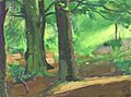
The woods at Cupid's Green, painted by Ashley George Old in 1959.
-
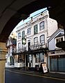
The Old Bell pub in Hemel old town has parts built in 1615. It is on the site of even older inns. It has unusual French wallpaper from 1821.
-
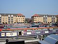
Apsley Marina, Hemel Hempstead, built in 2003.
-
The Church of St Mary's (1871) stands above the modern Sainsbury's supermarket in Apsley.
-
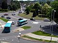
Northeast side of the Magic Roundabout, Hemel Hempstead. The "roundabout" is a series of 6 mini roundabouts around a larger looped system.
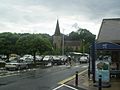
-
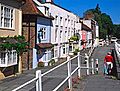
Hemel Hempstead Old Town.
-
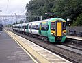
A Southern train at Hemel Hempstead.
-
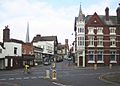
Hemel Hempstead high street in the Old Town.


See also
 In Spanish: Hemel Hempstead para niños
