River Bulbourne facts for kids
Quick facts for kids Bulbourne |
|
|---|---|

River Bulbourne in Berkhamsted (reduced by the Grand Union canal a couple of metres away)
|
|
| Country | United Kingdom |
| Physical characteristics | |
| Main source | Cow Roast/ Dudswell, Northchurch 120 m (390 ft) 51°46′41″N 0°36′04″W / 51.778°N 0.601°W |
| River mouth | Two Waters Apsley, Hemel Hempstead 90 m (300 ft) 51°44′20″N 0°28′16″W / 51.739°N 0.471°W |
| Length | 11 km (6.8 mi) |
The River Bulbourne is a small river in Hertfordshire, England. The word "bourne" comes from an old English word for a stream. This river is a tributary of the River Gade. The Gade then flows into the River Colne, which eventually joins the famous River Thames.
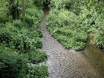
The Bulbourne is special because it is a chalk stream. This means its water comes from underground chalk rock. Chalk streams are very rare around the world. More than 85% of all 210 known chalk streams are found right here in England!
Contents
Where is the River Bulbourne Located?
The Bulbourne river flows through the Chiltern Hills. These hills are part of a larger system of chalk lands across eastern and southern England. These chalk lands formed about 84 to 100 million years ago. Back then, this area was covered by a sea where chalk was deposited.
The valley where the river flows has smooth, rounded sides. This shape was created by ice erosion during the last Ice Age. Near Berkhamsted, the valley sides rise about 300 feet high. The river sits on the northern edge of a large downward fold in the rocks called the London Basin. The ground beneath the river is mostly chalk. In some places, the chalk can be seen on the east side of the valley. The soil on top is mainly a reddish clay, but in the valley itself, the chalk is covered by river deposits.
What is the River Bulbourne's Path?
The Bulbourne flows in a south-easterly direction. It starts between Cow Roast and Dudswell in Northchurch. From there, it passes through Berkhamsted, Bourne End, and Boxmoor.
Finally, it joins the River Gade at a place called Two Waters in Apsley. This is near Hemel Hempstead. The river is about 7 miles (11 km) long. From its start to where it joins the Gade, it drops about 30 meters (90 feet) in height.
How Has Human Activity Changed the River?

The River Bulbourne used to have many eels and other fish. It flowed quickly and often flooded in some areas. Over many years, people have changed the river a lot. For example, the river's source (where it begins) has moved over time.
Ancient Times and the River
People started living in the Bulbourne valley even before the Iron Age. The upper valley had lots of wood and iron ore. During the late Iron Age, an area around Northchurch was a big center for making iron. This was one of the most important industrial areas in England during Roman times.
Water from 14 wells near the river at Cow Roast was used. A Roman town grew up here, next to the river and the Roman road, Akeman Street. Iron production stopped when the Roman period ended. Roman villas (large country houses) were also found in Northchurch, Berkhamsted, and Boxmoor.
Medieval Uses of the River
Early Anglo-Saxon settlements grew in Northchurch and Berkhamsted. In the Medieval period, the Bulbourne powered two watermills in Berkhamsted. These mills were recorded as early as 1086. Another mill was in Bourne End.
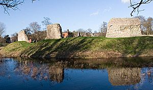
The river also filled the three moats around the large Berkhamsted Castle. This castle was built by the Normans and stands near the town center. The river also created a marshy area around the castle. This marsh acted as an extra defense, though it was sometimes called an "unhealthy swamp."
The Industrial Age and the Canal
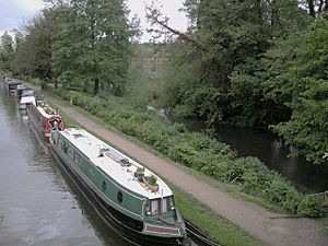
During the Industrial Age, in 1797, the Grand Union Canal was built next to the entire length of the river. The Bulbourne became the main water source for this canal. The canal was a key link between London and the coal mines in the Midlands. It was the only canal built across the Chiltern Hills.
Keeping enough water in this chalk region was a big challenge. Engineers had to build reservoirs, pumps, and boreholes. After the Roman road and the canal, the third major transport route was the London to Birmingham railway, built in 1834. By 1883, people were turning the "dirty ditches and offensive marshes" into watercress beds. Over centuries, the river's flow was reduced by more drinking water needs, dredging, milling, farming, and the canal.
Modern Water Concerns
In October 2011, people worried when the River Bulbourne dried up. Some locals thought it was because of new buildings in Berkhamsted using more water. However, the Environment Agency and the water company Veolia said it was due to a low water table. This low water table was caused by not enough rainfall.
What are the River Bulbourne's Tributaries?
The Bourne Gutter is a short tributary of the Bulbourne. It is about 400 yards (366 meters) long. It starts between Berkhamsted and Bourne End. In very wet years, it flows from springs nearly three miles further up a side valley. Local stories say it's a "Woe Water," meaning it only flows during times of national emergency.
Another small tributary was about 60 feet (18 meters) long at St Johns Well Lane in Berkhamsted. This stream dried up in the 1930s. This happened because more water was being pumped out of the ground nearby. For centuries, the "holy well" there had been Berkhamsted's main source of drinking water.
How is the River Being Restored?
The Bulbourne flows through Boxmoor. In January 2017, a big project started to restore a part of the river here. The Box Moor Trust worked with the Environment Agency to restore a kilometer (about 0.6 miles) of the river.
In the past, this part of the river had been changed a lot. It was too deep, straight, and wide. The restoration work aimed to make the river more natural. Most of the work happened in January 2017. They also created temporary ponds in November 2017.
This project, called 'Bringing Back the Bulbourne,' won an award for the 'best medium scale' project at The Wild Trout Trust Conservation Awards. The project helped bring back the natural curves of this chalk stream. This created new homes for plants and wildlife. Removing a weir (a small dam) allowed fish to move freely along the river. Cutting back trees also let more sunlight reach the water.
 | Misty Copeland |
 | Raven Wilkinson |
 | Debra Austin |
 | Aesha Ash |


