Thames and Severn Canal facts for kids
Quick facts for kids Thames and Severn Canal |
|
|---|---|
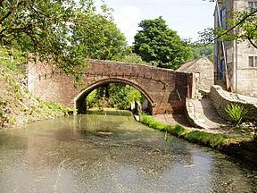
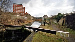
The canal at Brimscombe
|
|
| Specifications | |
| Length | 28.7 miles (46.2 km) |
| Locks | 44 |
| Status | Some restoration since 1972 |
| History | |
| Original owner | Thames and Severn Canal Company |
| Principal engineer | Josiah Clowes |
| Date of act | 1783 |
| Date completed | 1789 |
| Date closed | 1933 |
| Geography | |
| Start point | Lechlade, River Thames |
| End point | Wallbridge, near Stroud |
| Connects to | River Thames, Stroudwater Navigation, Wilts & Berks Canal |
The Thames and Severn Canal is an old canal in Gloucestershire, England. It was finished in 1789. This canal was planned to be part of a water route connecting Bristol to London.
At its eastern end, the canal joins the River Thames at Inglesham Lock near Lechlade. At its western end, it connects to the Stroudwater Navigation at Wallbridge, near Stroud. From there, boats could reach the River Severn. The canal also has a short branch that goes from Siddington to the town of Cirencester.
A special part of the canal is Sapperton Tunnel. When it was built, it was the longest canal tunnel in Britain. It is still the second-longest complete tunnel today. The canal often had problems getting enough water. No large water storage areas (reservoirs) were built. Also, the highest part of the canal, near the tunnel, went through limestone rock. This rock let water leak out easily.
By the late 1800s, trains (railways) became very popular. They took away most of the canal's business. Most of the canal was closed in 1927, and the rest closed in 1941.
Since 1972, a group called the Cotswold Canals Trust has been working to fix up both the Thames and Severn Canal and the Stroudwater Navigation. Their goal is to connect the Thames and the Severn rivers by water again. Many parts of the canal have been repaired, and some sections now have water in them. In 2003, a big step forward happened when the Trust asked for £82 million from the Heritage Lottery Fund. This money would help restore both canals. The project was split into smaller parts. In 2006, £11.9 million was given for the first part. This money, plus other funds, will help restore the canal from 'The Ocean' at Stonehouse to Wallbridge, and then to Brimscombe Port. In 2010, the Trust was given Inglesham Lock by British Waterways. The Inland Waterways Association started a national effort to raise money to fix this lock and a section of the canal above it. To fully reopen the canal, some big engineering challenges still need to be solved.
Contents
Building the Canal: A Look Back
Since the 1730s, people had wanted to build a waterway connecting London and Bristol. The Stroudwater Navigation was opened in 1779. Within two years, its owners asked for a study to build a canal from Dudbridge to Cricklade. This canal would complete the link.
Engineers like John Priddy and Sir Edward Littleton were involved. Priddy suggested better starting and ending points at Wallbridge and Lechlade. Another engineer, Robert Whitworth, looked at two routes. The first route was chosen because it seemed to have plenty of water at Cirencester. However, the amount of water they thought was available turned out to be much less.
The canal was expected to cost £127,916. Most of this money was promised quickly. A law to allow the canal to be built was passed on April 17, 1783. The company could raise £130,000 at first, and an extra £60,000 if needed. The canal was designed for boats about 12 feet (3.7 m) wide. This meant it could fit Thames barges.
Josiah Clowes was hired as the main engineer in 1783. He was paid £300 a year. Clowes' work on the canal made him very famous. He left the project just before it was finished to work on Dudley Tunnel.
Building the Sapperton Tunnel
There was a big discussion about how wide the tunnel at Sapperton should be. Some thought it should be narrow because a wider tunnel would cost too much. It was also going to be the longest tunnel ever built. However, they decided to build it as a wide tunnel, 15 feet (4.6 m) wide and high.
Work on the tunnel started in early 1784. It was expected to take four years, but it was not finished until April 1789. The canal opened in sections as they were completed. The first 4 miles (6.4 km) from Wallbridge to Chalford opened in January 1785. By mid-1786, boats could reach the western entrance of the tunnel. This section was 7.5 miles (12.1 km) long and had 28 locks. A storage area (wharf) was built at Daneway Bridge, with a warehouse and coal yard.
The tunnel was built by digging from many different spots. Workers dug 25 shafts along its path to get inside. After it was finished, there were problems. The tunnel was closed for two and a half months in 1790 for more work. The highest part of the canal and a branch to Cirencester were finished in 1787. They started working as soon as the tunnel opened. The last part, which connected to the Thames at Inglesham, was finished in November 1789. This section went down through 16 locks.
The canal cost £250,000 to build. With the Stroudwater Navigation, which was finished in 1779, it created a link between the River Severn in the west and the River Thames in the east.
The main canal line was just under 28.7 miles (46.2 km) long and had 44 locks. The branch to Cirencester added another 1.5 miles (2.4 km). The first 2.5 miles (4.0 km) from Wallbridge to Brimscombe had locks 69 by 16 feet (21.0 by 4.9 m). This allowed larger Severn trows (boats) to use it. Beyond that, the locks were 90 by 12.7 feet (27.4 by 3.9 m) for Thames barges.
The canal's highest point is 362 feet (110 m) above sea level and 8.1 miles (13.0 km) long. It includes the 3,817-yard (3,490 m) Sapperton Tunnel. At the time, this was the longest tunnel in England. Only two other canal tunnels have been longer: at Standedge and at Strood.
How the Canal Worked
At first, not much thought was given to how the canal would get enough water. People thought the River Frome, the River Churn, the River Coln, and some springs would be enough. A wind pump was used at Thames Head, but the engineer, Clowes, found that the highest part of the canal was leaking. The River Churn provided much less water than expected. The canal was losing a lot of water each day, mainly because the ground was limestone, which lets water through.
To fix this, the wells at Thames Head were made deeper. A steam engine was installed in 1792 to pump water into the canal. An extra, shallow lock was built at Boxwell to get more water from the springs there. These new methods helped, partly because the canal was not as busy as expected.
Water was also lost when springs broke through the clay lining of the canal bed. In summer, when springs dried up, water leaked out faster than it could be replaced. To save water, the length of the locks was made shorter by 20 feet (6.1 m). This gave them an unusual double-headed look. In another effort to stop leaks, a section of the canal near Sapperton Tunnel was lined with concrete instead of clay.
The rivers the canal connected to were not always easy to use. In the west, this improved in 1820 when the Gloucester and Sharpness Canal was built. On the Thames, some improvements were made after 1786. The canal company also encouraged building bypasses. The Wilts & Berks Canal was one of these. It connected to the Thames at Abingdon, but it opened much later in 1810. The North Wilts Canal, which connected Latton to Swindon, was not finished until 1819. In the end, most trade between Bristol and London used the Kennet and Avon Canal after it opened in 1810. This route was much shorter than the Thames and Severn Canal.
The Canal's Decline
Competition from railways started in 1836. The Cheltenham and Great Western Railway planned a line between Swindon and Cheltenham. The canal company fought against this plan. They received £7,500 from the railway company over four and a half years as payment. The railway line opened to Kemble in 1841. For a short time, the money from carrying materials for the railway helped the canal financially.
The railway company was then taken over by the Great Western Railway. They built a new tunnel at Sapperton and opened the railway to Gloucester in 1845. The canal cut its prices (tolls) to try and keep business. But the money from tolls still dropped from £11,000 to £2,874 between 1841 and 1855. The Thames Commissioners, who managed the Thames, also had money problems. The Thames became almost impossible to use from Oxford to Lechlade after 1855.
In 1866, plans to turn the canal into a railway were rejected. But the Thames Commissioners were replaced by the Thames Conservancy. Most of the river was soon made usable again.
The canal continued to get worse. People complained about its condition in 1874 and 1885. Studies were done, but little was fixed. In 1893, the Thames and Severn company announced that the canal between Chalford and Inglesham would close. After talks with many groups, a new law was passed in 1895. This law created a Trust to raise £15,000 to fix the canal. The Trust included representatives from various canal companies and local councils.
While the Trust fixed the canal, the upper Thames was also improved. The canal reopened in March 1899. However, it soon closed again because there was not enough water at the highest level. Gloucestershire County Council then took over the canal on July 2, 1901. In 1925, they started talks that led to the canal being closed from Chalford to Inglesham in 1927. The Stroudwater Navigation kept its part of the canal open until 1933, when it was also closed. Their own canal closed in 1941.
Bringing the Canal Back to Life
In 1972, a book called Lost Canals of England and Wales was published. This book inspired many groups to start fixing up old canals. One of these groups was the Stroudwater Canal Society, which later became the Cotswold Canals Trust. Since then, volunteers have been working to restore both the Stroudwater Navigation and the Thames and Severn Canal.
In 1979, the Trust convinced Gloucestershire County Council to rebuild a damaged bridge at Daneway. This was important because a cheaper, lower bridge would have blocked the canal route. Two years later, the project received help from a government scheme. This scheme provided 20 workers and money for materials.
In 1991, the Trust hired engineers to study how to restore the eastern end of the canal. This study showed that a navigable tunnel (culvert) should be built under the planned Latton Bypass. Even though it was first said that no culvert would be built, talks continued. With grants from local councils, the government decided in 1997 that a culvert would be built under the road.
Finding Money for Restoration
To help the restoration move forward, the Cotswold Canals Partnership was formed in 2001. This group brought together different organizations and councils. In 2002, the canal was named a high-priority project. The estimated cost to fix it was £82 million. The Trust raised £100,000 and hoped to use it to get more grants.
Andy Stumpf became the full-time manager for the restoration project. He worked on a big application for money from the Heritage Lottery Fund (HLF). Prince Charles, who supports the Waterways Trust, visited the canal. A study of the canal's history and plans for community and visitors were also made. These were needed for the HLF application.
The HLF asked for the project to be split into smaller parts. In late 2003, a first grant of £11.3 million was given by the HLF. This money was for restoring the Stroudwater Navigation between Stonehouse and Wallbridge. It also covered the Thames and Severn Canal between Wallbridge and Brimscombe Port. An extra £2.9 million came from a European fund. By January 2006, the grant had grown to £11.9 million. Another £6 million came from a regional development agency. Besides these big projects, the Trust has rebuilt many locks and bridges. Some small parts of the canal now have water in them.
In 2008, British Waterways left the partnership due to money problems. Stroud District Council took over as the project leader. A new group, the Stroud Valleys Canal Company, was created in 2009. This company now owns most of the canal bed between Wallbridge and Brimscombe. They will manage and maintain the canal once it reopens.
The cost of the restoration was higher than expected. So, the Heritage Lottery Fund agreed to give an extra £800,000 in December 2012. This money helped finish the restoration between Stonehouse and Bowbridge. It also helped improve the towpath to Brimscombe Port. Volunteers would handle work on the canal beyond Bowbridge.
Restoration Progress: Step by Step
The restoration is divided into several main phases. Phase 1a covers 6 miles (9.7 km) of the hardest section to restore, around Stroud. This includes parts of the Stroudwater Navigation and the Thames and Severn Canal. Phase 1b connects the finished Phase 1a section to the wider canal network at Saul Junction. Phase 2 focuses on the eastern end of the canal, between Gateway Bridge and Inglesham Lock. Phase 3 will complete the project, connecting Brimscombe Port to Gateway Bridge, including Sapperton Tunnel.
Phase 1a: Stroud Area Restoration
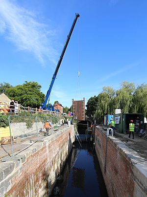
Phase 1a covers the canal from The Ocean at Stonehouse to Brimscombe Port. This is about 6 miles (9.7 km) long. The work involves fixing 10 locks, rebuilding 10 bridges, and refilling about 2,100 yards (1,900 m) of canal that had been filled in. It also includes a major rebuild of Brimscombe Port.
Money was available for all the planned work. However, rising costs have slowed down the project. A new plan, with more help from volunteers, aims to finish restoration to Bowbridge by the end of 2015. Other major work further east is on hold. Phase 1a also included a path for walkers and cyclists between Stonehouse and Saul. This path will likely be built in Phase 1b.
The last part of the canal before it joins the Stroudwater Navigation is difficult to restore. This section was used to help control floods. Water from the Slad Brook joins the canal near Lower Wallbridge Lock. Other streams also join the channel. Because it helps with flood control, this part of the canal is called a "main river". The plans for restoring the canal here had to allow for large water flows. They include underground bypass tunnels to carry floodwater.
At Capels Mill, the canal bed was used for the Stroud Bypass in the 1980s. So, a new path for the canal had to be built here. This new path goes through an area that was a landfill site in the 1960s and 1970s. About 355 yards (325 m) of new canal channel were built. Some parts are supported by strong concrete walls. As the project neared completion, public open days were held in May 2013. Over 1,800 people walked along the bottom of the new canal section. Any old rubbish that had to be moved was covered with concrete, a special fabric, and soil. Vents allow any gas from the rubbish to escape safely. The new section was filled with water and officially opened on June 2, 2013.
An evaluation trip was held on November 10, 2017. Important people from the Heritage Lottery Fund and local councils traveled on the canal. They went from The Ocean at Stonebridge to Bowbridge Lock. This trip allowed the HLF to see the work and officially approve Phase 1a. An official opening of Wallbridge Lower Lock happened on February 2, 2018. Prince Charles cut a ribbon to celebrate the reconnection of the Thames and Severn Canal with the Stroudwater Navigation.
During Phase 1a, it became clear there would not be enough money. This was partly because the development of Brimscombe Port was delayed. So, the HLF-funded work ended at Bowbridge Lock. Work up to Hope Mill Lock has been done mostly by volunteers. Some work to prepare the Brimscombe Port site was funded by a £2 million grant in October 2015. Volunteers finished restoring Griffin's Mill Lock in 2017. The lock was opened on July 9, 2018. Work had already started on Ham Mill Lock, the next one upstream. Water supply to the restored section was improved by building a siphon at Geogh's Orchard Lock. This siphon takes water from a millpond and feeds it into the lock. A solar-powered pump helps start the siphoning.
Phase 1b: Connecting to the Network
The second phase of the restoration covers the Stroudwater Navigation between the Ocean Railway Bridge and Saul Junction. This is about 4 miles (6.4 km) long. This work is simpler and includes building two new locks and fixing six others. It also involves building several small road bridges and refilling about 1 mile (1.6 km) of canal.
This section has some big engineering challenges. A new railway bridge is needed at Stonehouse. The canal bed has been used by the River Frome and Oldbury Brook. Also, the original canal route is now blocked by the M5 motorway and the A38 road. Plans to overcome these problems exist, but they need funding.
The Trust will protect this section until money is available. Previous requests for Heritage Lottery funding were turned down. A new request was made in November 2017. It is supported by promises of money from Stroud District Council, Gloucestershire County Council, and the Canal and River Trust. The Cotswold Canals Trust has also offered money and volunteer help.
Phase 2: Eastern End Restoration
Phase 2 covers the eastern end of the canal. This is between Gateway Bridge in the Cotswold Water Park and Inglesham Lock. It is about 10 miles (16 km) long. This section does not have as many big engineering problems as other parts. However, land ownership is an issue, and several miles of canal around Kempsford have been filled in. Money is only available for small projects. But several locks have been largely restored, and parts of the towpath have been rebuilt.
In 2002, British Waterways bought Inglesham Lock and the nearby round house. This was to protect the canal route. After they left the restoration project, they sold the house to a member of the Cotswold Canals Trust. They also gave ownership of the lock to the Trust. In June 2010, the Inland Waterways Association (IWA) started a national campaign to raise £125,000. This money was to restore Inglesham Lock and about 420 yards (380 m) of the canal above it.
Phase 3: Completing the Link
Phase 3 is the final part of the project. It will connect Brimscombe Port in the west with Gateway Bridge in the east. This is about 16 miles (26 km) long. Restoring this middle section has several major difficulties. First, the water supply was always a problem. Second, the 2.2-mile (3.5 km) Sapperton Tunnel is blocked by two rock falls. Also, two railway bridges are missing, and an aqueduct and 31 locks need to be rebuilt. As of May 2015, there was no major funding for restoration projects on this part of the canal.
Special Buildings Along the Canal
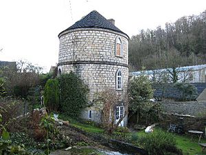
Many of the buildings connected to the canal are still standing. Some are listed as historic buildings. This includes five round cottages, built with three floors. The bottom floor was for storage and had an outside entrance. Steps led up to the first floor, which was about 16 feet 10 inches (5.13 m) wide. This was the living area and had a cooking range. A staircase inside the walls led to a round bedroom on the second floor.
These round houses are located at Lechlade (the Round House, Inglesham), Marston Meysey, Cerney Wick, Coates (near the tunnel entrance), and Chalford. Some had pointed slate roofs, while others had a lead cone that collected rainwater for drinking. They were built in the 1790s for lock-keepers and lengthmen (people who looked after sections of the canal). However, they were not very popular because they were small and it was hard to find furniture for a round room.
Canal in Books
In 1953, C. S. Forester wrote Hornblower and the Atropos. This historical novel is set during the Napoleonic Wars. In the book, Horatio Hornblower, a captain in the Royal Navy, travels along the canal to London. He helps with legging (pushing with feet against the tunnel walls) the boat through the Sapperton tunnel. He then steers it after the person in charge of the horses gets hurt.
Places of Interest
| Point | Coordinates (Links to map resources) |
OS Grid Ref | Notes |
|---|---|---|---|
| Wallbridge lower lock | 51°44′40″N 2°13′27″W / 51.7444°N 2.2241°W | SO846050 | Junction with Stroudwater Navigation |
| A419 on canal bed | 51°44′30″N 2°12′53″W / 51.7418°N 2.2146°W | SO852048 | Diversion required |
| Bowbridge Lock | 51°44′12″N 2°12′27″W / 51.7367°N 2.2075°W | SO857042 | |
| Ham Mill Lock | 51°43′39″N 2°12′18″W / 51.7274°N 2.2049°W | SO859032 | |
| Hope Mill lock | 51°43′17″N 2°11′50″W / 51.7214°N 2.1971°W | SO864025 | |
| Brimscombe Port | 51°43′12″N 2°11′37″W / 51.7199°N 2.1936°W | SO867023 | End of Phase 1 |
| Bourne Lock | 51°43′05″N 2°11′10″W / 51.7180°N 2.1860°W | SO872021 | |
| St Marys Lock | 51°43′07″N 2°10′01″W / 51.7185°N 2.1670°W | SO885022 | |
| Chalford Wharf | 51°43′16″N 2°09′31″W / 51.7210°N 2.1587°W | SO891024 | |
| Chalford Lock | 51°43′16″N 2°08′28″W / 51.7210°N 2.1410°W | SO903024 | |
| Puck Mill Upper Lock | 51°43′30″N 2°06′57″W / 51.7251°N 2.1158°W | SO920029 | |
| Daneway locks, Wharf cottage | 51°43′44″N 2°05′27″W / 51.7290°N 2.0907°W | SO938033 | crossed River Frome |
| Sapperton Tunnel west portal | 51°43′43″N 2°04′57″W / 51.7286°N 2.0826°W | SO943033 | |
| Sapperton Tunnel - miners' access shaft | 51°43′23″N 2°04′30″W / 51.723°N 2.075°W | SO949027 | |
| Sapperton Tunnel - miners' access shaft | 51°43′03″N 2°04′05″W / 51.7175°N 2.068°W | SO953020 | |
| Sapperton Tunnel - east portal | 51°42′15″N 2°03′01″W / 51.7041°N 2.0504°W | SO966005 | |
| Tarlton, Lengthman's Roundhouse | 51°41′59″N 2°02′41″W / 51.6997°N 2.0448°W | SO970001 | disused |
| Trewsbury House | 51°41′56″N 2°01′55″W / 51.699°N 2.032°W | SO978000 | Coates, Gloucestershire |
| Thames Head bridge - A433 crossing | 51°41′25″N 2°01′17″W / 51.6904°N 2.0215°W | ST986990 | also site of Thames Head Pumping Station. |
| A429 crossing | 51°41′17″N 2°00′14″W / 51.688°N 2.004°W | ST998988 | A429 covers canal-bed |
| Ewen wharf | 51°41′06″N 2°00′00″W / 51.685°N 2.00°W | SU000984 | Railway bridge |
| Park Leaze & Furzen Leaze pound | 51°41′11″N 1°59′10″W / 51.6865°N 1.986°W | SU010986 | |
| Spratsgate lane | 51°41′32″N 1°58′01″W / 51.6922°N 1.967°W | SU023992 | lane blocks canal bed |
| Cirencester arm | 51°41′46″N 1°57′30″W / 51.696°N 1.9583°W | SU029996 | |
| Siddington locks | 51°41′42″N 1°57′18″W / 51.695°N 1.955°W | SU032995 | Siddington |
| River Churn crossing | 51°41′17″N 1°56′36″W / 51.688°N 1.9432°W | SU040988 | disused |
| South Cerney locks | 51°40′48″N 1°55′37″W / 51.68°N 1.927°W | SU051979 | South Cerney - disused section |
| lock | 51°40′39″N 1°55′08″W / 51.6776°N 1.919°W | SU056976 | disused lock |
| lock | 51°40′26″N 1°53′55″W / 51.674°N 1.8985°W | SU071972 | disused lock |
| Cerney Wick lock | 51°39′47″N 1°53′17″W / 51.663°N 1.888°W | SU078960 | disused lock |
| locks | 51°39′40″N 1°53′10″W / 51.661°N 1.886°W | SU079958 | disused lock |
| Latton Junction, North Wilts canal basin | 51°39′25″N 1°52′34″W / 51.657°N 1.876°W | SU087954 | North Wilts Canal |
| A419 Cricklade | 51°38′56″N 1°51′11″W / 51.649°N 1.853°W | SU102944 | A419 - disrupted section |
| Eysey (Eisey) lock | 51°39′14″N 1°49′37″W / 51.654°N 1.827°W | SU120950 | disused |
| Marston Meysey - Roundhouse farm | 51°39′54″N 1°48′47″W / 51.665°N 1.813°W | SU130962 | Marston Meysey disused section |
| Kempsford | 51°40′08″N 1°46′23″W / 51.669°N 1.773°W | SU157967 | Kempsford disused section |
| Dudgrove double lock | 51°40′44″N 1°43′12″W / 51.679°N 1.72°W | SU194978 | disused section |
| Inglesham Lock & Roundhouse | 51°41′16″N 1°42′19″W / 51.6877°N 1.7054°W | SU204988 | junction with River Thames |
 | Janet Taylor Pickett |
 | Synthia Saint James |
 | Howardena Pindell |
 | Faith Ringgold |


