
Gloucester and Sharpness Canal facts for kids

The Gloucester and Sharpness Canal is a famous waterway in the west of England. It's also known as the Gloucester and Berkeley Canal. This canal connects the city of Gloucester to the town of Sharpness.
For most of its journey, the canal runs near the River Severn. It helps boats avoid a big, tricky bend in the river near Arlingham. This canal was once the widest and deepest canal in the whole world! It is about 26.5 kilometers (16.5 miles) long.
Contents
Building the Canal
People first thought about building this canal during a time called "canal mania" in the late 1700s. It was first called the Gloucester and Berkeley Ship Canal. An architect and civil engineer named Robert Mylne started the project.
In 1793, a special law was passed by Parliament. This law allowed the builders to raise £200,000 to pay for the canal. But the project quickly ran into money problems. Robert Mylne even left the project in 1798 because of these issues.
By 1799, they had spent £112,000. But only about 5.5 miles of the canal were finished. James Dadford took over from Robert Mylne. However, the company ran out of money and stopped employing Dadford in 1800.
Finding More Money
For ten years, from 1800 to 1810, people tried to get more money for the canal. But nothing worked. Some money from tolls (fees for using the canal) and rents helped improve the basin in Gloucester in 1813.
The Canal Opens!
Things changed in 1817. A law called the Poor Employment Act allowed the company to borrow money. They got funds from the Exchequer Bill Loan Commission. They also sold more shares in the company.
Finally, after many delays, the canal opened in April 1827. Building the canal cost a huge amount: £440,000. When it opened, the canal was 86.5 feet wide and 18 feet deep. It could handle ships weighing up to 600 tons. The longer of its two locks was 115 feet long.
The Severn Railway Bridge
In 1879, the Severn Railway Bridge was built. It crossed over the canal. A special swing bridge section was added to the railway bridge. This allowed tall boats to pass underneath without hitting the bridge.
The Purton Hulks
In 1909, part of the riverbank collapsed. The canal company's chief engineer, A. J. Cullis, had an idea. He suggested running old boats aground along the bank of the River Severn, near Purton. This would create a barrier to stop the river from washing away the land between the river and the canal.
Barges, trows, and schooners were "hulked" (left to sink) at high tide. Over time, they filled with silt. More boats were added later. These included the schooner Katherine Ellen, which was seized in 1921. It was caught carrying guns to the IRA. Other boats included the Kennet Canal barge Harriett and ferrocement barges built during World War II.
In 1999, Paul Barnett started a project to record the 81 vessels at the site. This place is known as the largest ships' graveyard in mainland Britain. In 2010, British Waterways took over the site to help protect it.
The Canal Today
In 1905, over one million tons of goods passed through the canal. Oil became a new cargo, with large oil carriers bringing fuel to storage tanks south of Gloucester. In 1937, even submarines like HMS H33 and HMS H49 used the canal!
The canal became owned by the government in 1948. The Sharpness Dock Police, who had guarded the dock since 1874, joined the British Transport Police.
By the mid-1980s, most commercial traffic had stopped. The canal became mainly used by pleasure boats. Only a few grain barges still used it. The oil trade ended in 1985 when the petroleum depot at Quedgeley closed.
To build the A430 Gloucester southwestern bypass, the canal had to be moved. This new section removed a tricky double bend that had caused problems for commercial boats. The new part of the canal opened on May 6, 2006. In January 2009, work began to replace the Patch Bridge swing bridge. It now has a motor instead of being hand-cranked.
The Gloucester and Sharpness Canal connects directly to the Stroudwater Navigation at Saul Junction. Today, boats up to 64 meters (210 feet) long, 9.6 meters (31.5 feet) wide, and 32 meters (105 feet) high can use the canal. The deepest a boat can be is 3.5 meters (11.5 feet).
Images for kids
-
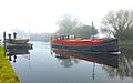
A motorized Dutch Barge passing a swing bridge on the Gloucester & Sharpness Canal.
-
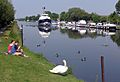
The canal at Patch Bridge, near the Wildfowl Reserve at Slimbridge.
-
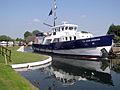
The Sea Cadet training ship TS John Jerwood passes through Patch Bridge on its way to the River Severn.
-
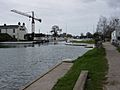
The Gloucester and Sharpness Canal at Saul Junction.
-
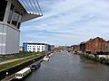
The Gloucester and Sharpness Canal at the entrance to Gloucester Docks.


