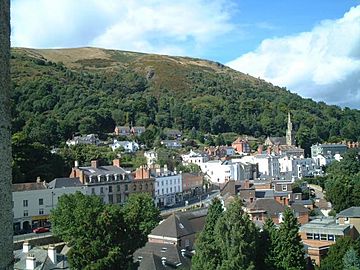
North Hill, Malvern facts for kids
Quick facts for kids North Hill |
|
|---|---|

North Hill from Great Malvern Priory
|
|
| Highest point | |
| Elevation | 397 m (1,302 ft) |
| Prominence | 15 m (50 ft) |
| Parent peak | Worcestershire Beacon |
| Geography | |
| Location | Malvern Hills, England |
| OS grid | SO768462 |
| Topo map | OS Landranger 150 |
| Geology | |
| Age of rock | Pre-Cambrian |
| Mountain type | Igneous, Metamorphic |
| Climbing | |
| Easiest route | Hiking |
North Hill is a cool spot in the Malvern Hills in England. It's the second highest point in this range of hills. The Malvern Hills stretch for about 13 kilometers (8 miles) from north to south.
North Hill is located entirely within Worcestershire. It stands tall at 397 meters (1,302 feet) above sea level. This makes it the highest point along the famous Worcestershire Way walking path.
You can find North Hill right behind Worcester Road in Great Malvern. It's a quick and steep walk from the town center. You can reach the top in about 15 to 20 minutes. Just follow St Ann's Road and Happy Valley. There's also a path from the car park in North Malvern. This path goes along the lower part of North Hill to Happy Valley and St. Ann's Well.
History of North Hill
Long ago, people used to trade goods across England. A special route for trading flint (a type of stone) went from North Wales to Wessex. This route was north of Malvern. But there is some proof that traders also crossed the Malvern Hills.
- Ancient Discoveries: Small pieces of an arrowhead have been found. Also, a scraper (a tool for cleaning animal hides) and flint flakes (sharp pieces of stone) were discovered. These items were found between North Hill and Table Hill.
- Burial Mounds: In the 1800s, a guide book mentioned a collapsed burial mound on North Hill. It was called the "Giant's Grave." Another mound was on Table Hill. These mounds, called tumuli, might have been linked to the Dobunni people. The Dobunni were an ancient British tribe who lived in a settlement in Mathon.
There's a path on North Hill that was known as the "Pyx Path." A "pyx" is a container used in churches. In the 11th century, a priest from Worcestershire used this path. He would bring the Sacrament (a holy ritual) to the hermits who lived in Malvern. Hermits were people who lived alone, often for religious reasons.
This path was also called the "Pixie Path." People believed that fairies used it! At the bottom of North Hill, near Worcester Road, you can find the Lodge spring. This spring has a pretty fountain. It looks similar to the fountains at St Ann's Well.
Folklore and Legends
Some people believe that North Hill is part of a special line of energy. A writer named Alfred Watkins wrote about this idea. He thought North Hill was the start of a "ley line." A ley line is an imaginary straight line that connects ancient sites.
He believed this line went from North Hill to other places. These included Pen-y-Beacon, Mathon Church, and several other old sites. It's a fun idea to think about ancient paths connecting special places!
The Worcestershire Way
The Worcestershire Way is a long-distance walking path. It was first created in 1989. Back then, it was 48 miles (77 kilometers) long. Part of it even went into Herefordshire.
In 2004, the path was changed. Now, it is entirely within Worcestershire. The last few miles of the path climb up the northern part of the Malvern Hills. It goes around End Hill and Table Hill. Then it follows Lady Howard de Walden's Drive on North Hill. Finally, it goes down to Great Malvern, passing by St Ann's Well. It's a great way to explore the beautiful Malvern Hills!
 | Aaron Henry |
 | T. R. M. Howard |
 | Jesse Jackson |

