
Lickey Hills facts for kids
The Lickey Hills, often called The Lickeys by local people, are a group of hills in Worcestershire, England. They are about 11 miles (18 km) southwest of Birmingham. You can find them near the villages of Lickey, Cofton Hackett, and Barnt Green. These hills are a very popular country park. From the top, you can see amazing views of the countryside all around.
Contents
Who Owns the Lickey Hills?
Long ago, the Lickey Hills were a special hunting area for the King. They belonged to the Manor of Bromsgrove. But things changed!
- In 1888, a group called the Birmingham Society for the Preservation of Open Space bought Rednal Hill. They gave it to the City of Birmingham so everyone could visit. This was the start of public access.
- Later, Pinfield Wood and Bilberry Hill were rented for a very small fee.
- In 1907, the Cadbury family (yes, like the chocolate!) bought Beacon Hill. They also gave it to the City of Birmingham.
- More land, including Cofton Hill, Lickey Warren, and Pinfield Wood, was bought in 1920.
- Finally, in 1923, the Rose Hill Estate was bought from the Cadbury family. This made sure even more of the area was open to everyone.
Today, Birmingham City Council owns and takes care of the Lickey Hills Country Park. Even though they manage it, most of the park is actually in Worcestershire, not Birmingham.
Exploring the Lickey Hills
The Lickey Hills have two main lines of hills with a valley in between. The Lickey Hills Country Park covers about 525 acres (2 square kilometers) of these hills. There's also a golf club here.
The lower line of hills is called the Lickey Ridge. It has three strong, rocky hilltops:
- Rednal Hill
- Bilberry Hill
- Cofton Hill
The higher line of hills includes:
- Rose Hill
- Beacon Hill (which is 298 meters or 978 feet high)
- Stock Hill
The Rocks of the Lickey Hills

The Lickey Hills are famous for their amazing variety of rocks. These rocks were formed at different times in Earth's history. This mix of rocks is why the area has so many different landscapes and natural places for plants and animals to live.
Here are some of the main types of rocks you can find:
- Barnt Green rocks: These are made from tuff (volcanic ash) and other volcanic bits. They also include siltstones and mudstones. They formed during the Ordovician period.
- Lickey Quartzite: This is a very hard rock called quartzite. It also formed during the Ordovician period and has thin layers of mudstone.
- Rubery sandstone: A type of sandstone that contains fossils. It formed during the Silurian period.
- Halesowen Formation: This is a mudstone from the Carboniferous period.
- Clent Formation: A type of rock called breccia, which is made of sharp, broken rock pieces cemented together. It formed during the Permian period.
- Bunter Pebble Beds: These are layers of smooth, rounded pebbles that were worn down by water. They formed during the Triassic period.
The Lickey Hills are like a big block of hard quartzite (the Lickey Ridge) that has been pushed up. The younger, softer rocks on either side have slipped down due to faults (cracks in the Earth's crust).
Beacon Hill: A Hill with a View and History
Beacon Hill is a very important spot in the Lickey Hills.
Long ago, a network of beacons was set up across the country. These were huge fires lit on hilltops to warn people if an invasion was coming. On Beacon Hill, there was a large iron basket where two men would watch day and night. A special map from the time of the Spanish Armada (1588) shows this beacon.
During World War II, the Army built several buildings on Beacon Hill. These were used by Air Raid Wardens who watched for fires over south Birmingham. Royal Observer Corps members also spotted enemy aircraft from here. They would set off air raid sirens for nearby towns like Rednal and Rubery, and for important factories like the Austin motors factory. One of the old toilet blocks, still painted in army green, was used by the public until the early 1970s!
In the 1950s, winters were very cold. The northern slope of Beacon Hill would be covered in snow for weeks. Hundreds of families would come here every day to go sledging! Today, winters are milder, and there isn't as much snow. Also, some houses and a golf course have been built on parts of the slope.
At the very top of Beacon Hill, you'll find a special monument called a toposcope. This was built to remember when the Cadbury family gave the land to Birmingham in 1907. The small castle-like building around it was rebuilt in 1988 to celebrate 100 years of the country park. From this spot, which is 298 meters (978 feet) above sea level, you can see amazing views of the city. Right next to it is an Ordnance Survey triangulation point, which helps mapmakers.
You can also find an obelisk in the hills. This tall, thin monument remembers the sixth Earl of Plymouth, who died in 1833. It thanks him for helping to create the Worcestershire Yeomanry, a volunteer regiment of cavalry (soldiers on horseback).
The Lickey Incline
About 1.5 miles (2.4 km) south of the hills is the Lickey Incline. This is a very steep part of the railway line. Since 1964, it has been known as the steepest main railway line in the UK where trains still rely on their wheels gripping the tracks. It's about 2 miles long, with some parts as steep as 1 in 36!
Fun Folklore
Local legends say that the Devil and his friend, Harry-ca-nab, used to hunt wild boar in the Lickey Hills. They would ride on white bulls!
Images for kids
-
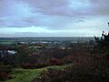
A view from the top of Bilberry Hill

