
The Wrekin facts for kids
Quick facts for kids The Wrekin |
|
|---|---|
 |
|
| Highest point | |
| Elevation | 407 metres (1,335 ft) |
| Prominence | 298 metres (978 ft) |
| Parent peak | Kinder Scout |
| Listing | Marilyn |
| Geography | |
| Location | Shropshire, England |
| Parent range | Shropshire Hills |
| OS grid | SJ628080 |
| Topo map | OS Landranger 127 |
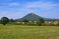
The Wrekin is a famous hill in Shropshire, England. It's about 8 kilometers (5 miles) west of Telford, right on the edge of the Shropshire and Telford and Wrekin areas. Standing tall at 407 meters (1,335 feet) above sea level, it's a well-known landmark. Many people see it when they enter Shropshire on the M54 motorway.
The Wrekin is part of the beautiful Shropshire Hills AONB (Area of Outstanding Natural Beauty). It's a popular spot for walkers and tourists. From the top, you can see amazing views across Shropshire. On a clear day, you might even see as far as Manchester or Gloucestershire!
Contents
What's in a Name?
The name Wrekin (pronounced REE-KIN) is very old. It was first written down in a document from 855 AD. People think its modern name comes from an old Celtic word, Wrikon-.
Long ago, a small Anglo-Saxon kingdom called the Wreocensæte lived in this area. For a few centuries, the Normans called the hill Mount Gilbert. This was named after a hermit (someone who lives alone for religious reasons) who lived there.
Reaching the Top


At the very top of the Wrekin, there's an Iron Age hill fort. This ancient fort is huge, covering about 8 hectares (20 acres). It's believed the Cornovii tribe built it and it was once their main town.
Around 47 AD, Roman invaders attacked the fort and burned it down. The defeated tribe then moved to Wroxeter, a Roman town nearby.
A more modern structure on the summit is the Wrekin transmitting station. This tall tower is used for broadcasting radio and TV signals. At night, a red light flashes from the top of the main mast. This light is called the "Wrekin Beacon."
A beacon was first put on the Wrekin during the Second World War to warn aircraft. It was used until 1960. A new beacon was installed in 2000 to celebrate the new millennium. You can see it from many miles away!
How the Wrekin Was Formed
The Wrekin is made of many different types of rocks. These rocks are very old, some dating back to a time before dinosaurs! The top of the Wrekin is made from volcanic rocks. These rocks are from ancient lava flows that happened about 680 million years ago. It was like a chain of volcanic islands, similar to Japan today.
Other rocks around the Wrekin include sandstone and shale. These were formed from layers of sediment. The Wrekin was never a volcano itself. However, it is made mostly of volcanic rocks. Its shape, which sometimes looks like a volcano, was formed by other natural processes over millions of years.
The Wrekin and Its Surroundings
The name the Wrekin is also used to talk about the wider area. This includes parts of East Shropshire around Telford and Wellington. This area is famous for being one of the birthplaces of industry. For example, the Ironbridge Gorge is just south of the Wrekin.
Lots of trees cover the hill and the area around it, stretching into the Ironbridge Gorge. The local parliamentary area is also named after the hill.
Getting to the Wrekin
You can get to the Wrekin from the last exit on the M54 motorway (Junction 7). This road then becomes the A5 towards Shrewsbury. The hill is signposted from there.
There's a popular path that goes up the side of the hill. You can start this path from the end of the road off the M54. There's also a small car park nearby. Another car park, at Forest Glen, is located between the Ercall and the Wrekin. The climb up the hill can be quite steep in some places.
Fun Stories and Traditions
The Wrekin has a famous legend in Shropshire folklore. Here's one version of the story:
A huge giant named Gwendol Wrekin was angry at the town of Shrewsbury. He decided to flood the town and get rid of everyone! So, he picked up a giant spadeful of earth and started walking towards Shrewsbury.
Near Wellington, he met a cobbler coming back from Shrewsbury market. The cobbler had a big bag of shoes to fix. The giant asked for directions. He also said he was going to dump his earth into the River Severn to flood the town.
"It's a very, very long way to Shrewsbury!" the clever shoemaker replied. "Look at all these shoes I've worn out walking back from there!" The giant immediately gave up his plan. He dumped the earth right there, and it became the Wrekin! The giant also scraped mud off his boots, which became the smaller Ercall Hill nearby. It's funny because Shrewsbury still gets flooded by the River Severn sometimes, naturally!
The phrase "All around the Wrekin" or "Right 'round the Wrekin" is common in this area. It means "the long way round," just like "round the houses." Also, "To all friends around the Wrekin" is a special toast used in Shropshire, especially at Christmas.
People also say the Wrekin can predict the weather: "If you can see the Wrekin, it's going to rain. And if you can't see the Wrekin, it's already raining."
Another local story says you're not a true "Salopian" (someone born in Shropshire) unless you've walked through the Needle's Eye. This is a crack between two big rocks near the top of the hill.
In 1981, local school kids and adults did an event called "Hands around the Wrekin." A large group of people held hands and surrounded the hill at its base.
There's even a cheese named after the Wrekin! It's called Wrekin White and is made in Newport, Shropshire.
Amazing Views


From the Wrekin, you can see very far! The furthest point you can probably see is the Forest of Bowland in north-east Lancashire. Even though some old maps and viewfinders at the top claim it, you can't actually see Snowdon from the Wrekin. The Cadair Berwyn mountains block the view.
Images for kids
-
The Wrekin
