
Cadair Berwyn facts for kids
Quick facts for kids Cadair Berwyn |
|
|---|---|

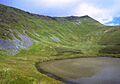
Cadair Berwyn and Llyn Lluncaws
|
|
| Highest point | |
| Elevation | 832 m (2,730 ft) |
| Prominence | 346 m (1,135 ft) |
| Listing | Marilyn, Hewitt, council top, Nuttall |
| Naming | |
| English translation | Chair of the White Summit |
| Language of name | Welsh |
| Geography | |

Cadair Berwyn
Location in Wales
|
|
| Parent range | Berwyn range |
| OS grid | SJ071323 |
| Topo map | OS Landranger 125 |
Cadair Berwyn, also called Cader Berwyn, is a tall mountain in north-east Wales. It stands 832 meters (about 2,730 feet) above sea level. This makes it the highest point in the Berwyn range of mountains. It is also the highest major peak in North East Wales. Plus, it's the tallest significant mountain outside of Wales's National Parks.
Contents
About Cadair Berwyn
Cadair Berwyn is part of the main Berwyn mountain ridge. This ridge runs from north to south. The eastern side of the ridge has steep drops and rocky cliffs. These include Craig Berwyn to the north and Craig y Llyn to the south. Craig y Llyn forms the back wall of a cwm. A cwm is a bowl-shaped valley often carved by glaciers. The Welsh word cadair means chair, which likely refers to this chair-like shape.
Further north along the ridge, you'll find Cadair Bronwen. To the south, the ridge continues to Moel Sych. Moel Sych means 'dry hill' in Welsh.
Finding the True Summit
For a long time, people thought Moel Sych was the same height as Cadair Berwyn. Moel Sych is only about 1 kilometer (0.6 miles) away. However, the official height on Ordnance Survey maps for Cadair Berwyn is where a trig point stands. A trig point is a marker used for surveying.
The true summit of Cadair Berwyn is actually about 200 meters (220 yards) south of this trig point. This real summit is 5 meters (16 feet) taller than Moel Sych. This higher point is known as Cadair Berwyn New Top on the Nuttall list. Its discoverer, Bernard Wright, called it Craig Uchaf.
How the Summit Was Discovered
In 1987, Bernard Wright, a hiker from Cheshire, made an important discovery. He was standing on Cadair Berwyn North Top, which was thought to be the highest mountain in Clwyd at the time. He noticed that a nearby peak looked even higher.
At first, mapmakers at the Ordnance Survey didn't agree. But eventually, they confirmed that Bernard had found a "new mountain." It was 830 meters (about 2,723 feet) high. Bernard named this peak Craig Uchaf, meaning 'highest rock'. This name fits well with how Welsh people have named their landscapes for centuries.
Near the summit, there is an ancient Bronze Age cairn. A cairn is a pile of stones built as a monument. In 2014, new surveys using GPS technology added another 2 meters to the height. This made the mountain even taller. The person who did this survey, Myrddyn Phillips, calls this summit Craig Berwyn.
Other Nearby Peaks
The Berwyn area has several other important peaks. These include Foel Wen, which means 'white hill' in Welsh. Another is Mynydd Tarw, meaning 'bull mountain'. These peaks are also popular with hikers.
Cadair Berwyn's Location
Cadair Berwyn is the highest point of the historic county of Denbighshire. The old border with Merionethshire also ran right through the summit. For a while, people thought Moel Sych and Cadair Berwyn North Top were the highest points of Denbighshire. But new surveys showed this was not true.
Today, the summit is entirely within the Powys council area. However, the border with the modern Denbighshire council is very close. It's only about 150 meters (490 feet) to the northwest. The northern end of the main ridge, called Craig Berwyn on the map, is the highest point in the Wrexham county borough.
Amazing Views
Cadair Berwyn stands between Snowdon and the Wrekin. It blocks the direct view between them. On a clear day, the view from the summit is incredible! You can see many famous places, including:
- Snowdon
- Cadair Idris
- Brecon Beacons
- Shropshire Hills
- Peak District
- Yorkshire Dales
- Lake District
- The Isle of Man
Even though it offers such great views, fewer people hike Cadair Berwyn. It's the closest tall mountain for many people in the English Midlands. But it sees far fewer walkers than similar mountains in the Lake District and Snowdonia.
Standing Stone and Lake
There is a standing stone near the summit, between Cadair Berwyn and Tomle. This stone was put back up in June 2008 by a group called High Sports. You can find the standing stone at grid reference SJ080337.
Below the mountain, there is a small lake called Llyn Lluncaws. It's a beautiful spot to visit.
Historical Events
Cadair Berwyn has been the site of a few interesting historical events:
- On August 11, 1942, a United States Army Air Forces Boeing B-17 Flying Fortress plane crashed into the side of Cadair Berwyn. Sadly, all eleven people on board died.
- In 1974, Cadair Berwyn and Cadair Bronwen were the location of a reported UFO landing. This event is known as the Berwyn Mountain UFO incident.
Images for kids
-
Cadair Berwyn and Llyn Lluncaws
