Cadair Idris facts for kids
Quick facts for kids Cadair Idris |
|
|---|---|
| Cader Idris | |

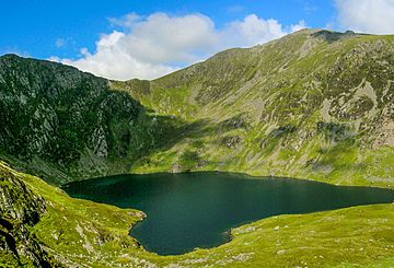
Llyn Cau with the summit of the mountain to the right
|
|
| Highest point | |
| Elevation | 893 m (2,930 ft) |
| Prominence | 608 m (1,995 ft) |
| Parent peak | Aran Fawddwy |
| Listing | Marilyn, Hewitt, Nuttall |
| Naming | |
| English translation | Chair of Idris |
| Language of name | Welsh |
| Pronunciation | Welsh: [ˈkadai̯r ˈɪdrɪs] |
| Geography | |
| Location | Gwynedd, Wales |
| Parent range | Snowdonia |
| OS grid | SH711130 |
| Topo map | OS Landranger 124, Explorer OL23 |
| Climbing | |
| Easiest route | Hike |
Cadair Idris () or Cader Idris is a famous mountain in Gwynedd, Wales. It sits at the southern edge of the Snowdonia National Park. This popular peak is a favorite for walkers and hikers.
The mountain is mostly made of Ordovician igneous rocks. These are rocks formed from cooled lava or magma. You can see many features shaped by glaciers here. These include bowl-shaped hollows called cwms, rock piles called moraines, and scratched rocks.
Contents
What's in a Name?
The Legend of Idris's Chair
The name Cadair Idris means 'Idris's Chair' in Welsh. People often say it refers to a giant named Idris. Imagine a giant sitting on top of the mountain!
Another story says it's named after Idris ap Gwyddno. He was a prince from the 7th century. He won a battle against the Irish on this very mountain. Some old family records even called him 'Idris the Giant'.
The Meaning of 'Cadair'
The Welsh word cadair means 'seat' or 'chair'. It comes from an old Greek word for chair. In place names, cadair can also mean 'stronghold' or 'fortress'. It can also describe a mountain shaped like a chair.
The spelling cader is a local way of saying cadair. Both spellings have been used for a long time. Today, maps usually show 'Cadair Idris'. The very top of the mountain is called Penygader, meaning 'top of the chair'.
Climbing Cadair Idris
| Listed summits of Cadair Idris | ||||
| Name | Grid ref | Height | Status | |
|---|---|---|---|---|
| Mynydd Moel | SH727136 | 863 m (2,831 ft) | Hewitt Nuttall |
|
| Cyfrwy | SH703133 | 811 m (2,661 ft) | Hewitt Nuttall |
|
| Craig Cwm Amarch | SH710121 | 791 m (2,595 ft) | Hewitt Nuttall |
|
| Gau Graig | SH744141 | 683 m (2,241 ft) | Nuttall | |
| Tyrrau Mawr | SH677135 | 661 m (2,169 ft) | Hewitt Nuttall |
|
| Craig-y-llyn | SH677135 | 622 m (2,041 ft) | Hewitt Nuttall |
|
There are three main paths to reach the top of Cadair Idris. The summit is covered in loose rocks called scree. At the very top, you'll find a trig point, which is a marker used for surveying. There's also a small stone shelter with a roof.
The Pony Path
The Pony Path (or Llwybr Pilin Pwn in Welsh) starts from the north. You can begin near Dolgellau or the Mawddach estuary. This path is the easiest way up, but it's also the longest. It's about 6 kilometers long and climbs 727 meters.
The Fox's Path
The Fox's Path (Llwybr Madyn) is the quickest way to the summit. It goes straight up the northern side of the mountain. This 3.8-kilometer climb includes going up a 310-meter cliff-like section. Be careful, as this part of the path has worn away quite a bit.
The Minffordd Path
The Minffordd Path (Llwybr Minffordd) begins on the mountain's southern side. It's close to the beautiful Tal-y-llyn Lake. Hikers on this path walk past Llyn Cau and along the edge of Craig Cau. This path is 4.4 kilometers long and has two steep climbs of over 300 meters.
The Mountain's Story in Rocks
How Cadair Idris Was Formed
Cadair Idris is made from many different kinds of rocks. These include sedimentary rocks like mudstones and siltstones. It also has igneous rocks like basalts and tuffs, which are volcanic rocks. These rocks were pushed and folded into shape a very long time ago.
Not a Volcano!

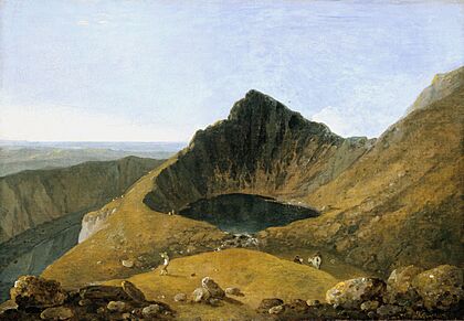
The bowl-shaped hollow called Cwm Cau looks a bit like a volcano crater. Because of this, some people used to think Cadair Idris was an extinct volcano. However, this idea was proven wrong over 150 years ago.
The "chair" shape of Cadair Idris was actually carved by cirque glaciers. These were huge masses of ice that moved slowly. During past ice ages, snow and ice built up on the slopes. The glaciers then scraped away the rock, forming the hollows and shaping the mountain.
Glacial Features and Lakes
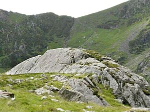
Near Llyn Cau, you can see tear-drop shaped hills called roches moutonnées. These were also formed by the moving ice. The two highest lakes on the mountain are Llyn Cau and Llyn y Gader. Llyn y Gader is about 13 meters deep.
Much of the area around Cadair Idris is a National Nature Reserve. It was given this special status in 1957. It's home to unique plants that grow in cold, high places. These include purple saxifrage and dwarf willow.
 | Dorothy Vaughan |
 | Charles Henry Turner |
 | Hildrus Poindexter |
 | Henry Cecil McBay |


