Mynydd Moel facts for kids
Quick facts for kids Mynydd Moel |
|
|---|---|

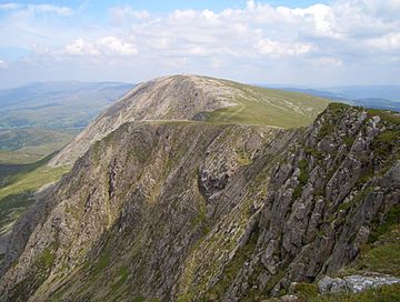
Mynydd Moel from Cadair Idris
|
|
| Highest point | |
| Elevation | 863 m (2,831 ft) |
| Prominence | 67 m (220 ft) |
| Parent peak | Cadair Idris |
| Listing | Hewitt, Nuttall |
| Naming | |
| English translation | Bare Mountain |
| Language of name | Welsh |
| Geography | |
| Location | Gwynedd, Wales |
| Parent range | Cadair Idris |
| OS grid | SH711130 |
| Topo map | OS Landranger 124, Explorer OL23 |
| Climbing | |
| Easiest route | Hike |
Mynydd Moel is a cool mountain peak located in the beautiful Snowdonia National Park in northwest Wales. It is the second highest point of the famous Cadair Idris mountain range. This peak stands tall in the county of Gwynedd.
Hikers often climb Mynydd Moel as part of a longer journey. They usually include it in a "horseshoe" walk. This means they hike in a loop that also takes them over Craig Cwm Amarch and the main Cadair Idris summit.
Exploring Mynydd Moel
Mynydd Moel means "Bare Mountain" in the Welsh language. This name fits it well! The top of the mountain is quite bare and rocky. You won't find many trees up there.
The Summit
At the very top of Mynydd Moel, you will see a pile of stones called a cairn. People often build cairns to mark the highest point of a mountain. They also use them to help hikers find their way. From the summit, you can enjoy amazing views of the surrounding area.
Steep Cliffs and Plateaus
Just like its bigger neighbor, Cadair Idris, the north side of Mynydd Moel has huge, steep cliffs. These rocky walls drop sharply, making the landscape look very dramatic.
To the east of Mynydd Moel, the land changes. It becomes a wide, flat area known as a plateau. This lower plateau is topped by another peak called Gau Graig. It's a great example of how different parts of a mountain range can look.
 | Aaron Henry |
 | T. R. M. Howard |
 | Jesse Jackson |

