Gau Graig facts for kids
Quick facts for kids Gau Graig |
|
|---|---|

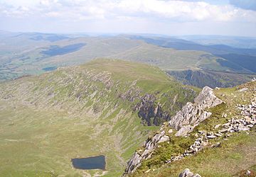
The Gau Graig plateau from Mynydd Moel
|
|
| Highest point | |
| Elevation | 684 m (2,244 ft) |
| Prominence | 25 m (82 ft) |
| Parent peak | Cadair Idris |
| Listing | Deleted Hewitt, Nuttall |
| Naming | |
| Language of name | Welsh |
| Geography | |
| Location | Gwynedd, Wales |
| Parent range | Cadair Idris |
| OS grid | SH744141 |
| Topo map | OS Landranger 124, Explorer OL23 |
| Climbing | |
| Easiest route | Hike |
Gau Graig is a mountain peak in Snowdonia National Park in Wales. It's like a smaller part of the bigger Cadair Idris mountain range. This peak is found in Gwynedd, which is in northwest Wales.
Gau Graig sits on a wide, flat, grassy area called a plateau. It's located to the east of another peak called Mynydd Moel. Gau Graig marks the very eastern end of the long ridge, or line of peaks, that makes up the Cadair Idris range.
What You'll Find at the Top
The very top of Gau Graig is marked by a cairn. A cairn is a special pile of stones that people have built. It helps hikers know they've reached the summit, which is the highest point.
From the top of Gau Graig, you can see many other mountains nearby. To the north, you can spot Y Garn and Diffwys. If you look to the west, you might see Rhobell Fawr and Aran Fawddwy. To the south, the mountains Waun-oer and Cribin Fawr are visible.
 | Isaac Myers |
 | D. Hamilton Jackson |
 | A. Philip Randolph |

