
Brecon Beacons facts for kids
Quick facts for kids Brecon Beacons |
|
|---|---|
| Bannau Brycheiniog (Welsh) | |
.jpg)
|
|
| Highest point | |
| Peak | Pen y Fan |
| Elevation | 886 (2,907ft) |
| Geography | |
| Location | Powys |
| Country | Wales, United Kingdom |
| Geology | |
| Age of rock | Devonian |
| Type of rock | Sedimentary |
| Brecon Beacons National Park Bannau Brycheiniog National Park Parc Cenedlaethol Bannau Brycheiniog (Welsh) |
|
|
IUCN Category V (Protected Landscape/Seascape)
|
|
| Lua error in Module:Location_map at line 420: attempt to index field 'wikibase' (a nil value). | |
| Location |
|
| Governing body | Bannau Brycheiniog National Park Authority |
The Brecon Beacons, also known as Bannau Brycheiniog (which is Welsh for "peaks of Brycheiniog"), is a beautiful mountainous area and national park in Wales. It's a popular place for people to visit and explore the outdoors. The highest mountain in the park is Pen y Fan, which stands at 886 metres (2,907 feet) tall.
The Brecon Beacons National Park was created in 1957. It was the third national park in Wales, after Snowdonia and the Pembrokeshire Coast National Park. About 4.4 million people visit the park every year to enjoy its stunning landscapes and many activities.
Contents
What's in a Name?
The name Bannau Brycheiniog comes from the Welsh words bannau, meaning "peaks", and Brycheiniog, which was the name of an old kingdom that covered this area. The English name "Brecon Beacons" came from the Welsh name. In the past, "Brecon Beacons" mostly referred to the mountains around Pen y Fan.
Today, to make it clear, the mountains themselves are sometimes called the "Central Beacons" to tell them apart from the larger national park.
Exploring the Geography


The Brecon Beacons National Park covers a large area of 1,344 square kilometres (519 square miles). It stretches from Llandeilo in the west to Hay-on-Wye in the northeast.
The park has three main mountain ranges:
- The Black Mountains in the east.
- The Brecon Beacons and Fforest Fawr uplands in the centre.
- The Black Mountain in the west.
The central Brecon Beacons range has six main peaks. From west to east, these are Corn Du (873 m), Pen y Fan (886 m), Cribyn (795 m), Fan y Bîg (719 m), Bwlch y Ddwyallt (754 m), and Waun Rydd (769 m). These peaks form a long ridge, and the first four create a horseshoe shape around the start of the Taf Fechan river.
The Black Mountains in the east are separated from the central Beacons by the River Usk valley. The highest mountain in this range is Waun Fach (811 m). The highest peak of the Black Mountain range in the west is Fan Brycheiniog, at 802.5 m.
You can also find amazing waterfalls in this area, like the 27-metre (90-foot) Henrhyd Falls and the Ystradfellte falls. There's also a huge cave system called Ogof Ffynnon Ddu on the edge of Fforest Fawr.
How the Mountains Were Made (Geology)
The mountains in the Brecon Beacons National Park are mostly made of sedimentary rocks. These rocks were formed from layers of sand, mud, and tiny bits of ancient sea creatures that settled over millions of years. The most common rock here is called Old Red Sandstone, which gives many of the mountains their reddish colour. Over time, the Earth's movements folded and faulted these rock layers, pushing them up to create the mountains we see today.
A Look Back in Time (History)
People have lived in the Brecon Beacons area for a very long time. During the Neolithic and Bronze Age (thousands of years ago), people built burial mounds, which you can still see on the hills. One mound on Fan Brycheiniog was dug up, and scientists found ashes from around 2000 BCE!
Later, in the Iron Age, over twenty hillforts were built. These were like ancient fortified towns. The biggest ones were y Gaer Fawr and y Gaer Fach near Bethlehem, Carmarthenshire. They were important places for trade and politics.

When the Romans came to Wales, they set up a main base called Y Gaer near the town of Brecon. After the Romans, during the Norman Conquest, many castles were built, including Carreg Cennen Castle and Brecon Castle.
For centuries, people called "drovers" used old tracks to move their cattle and geese to markets in England. They would even bring back gorse seeds to plant for their sheep to eat.
During the Industrial Revolution, the area was important for its natural resources. Things like limestone, sand, and ironstone were dug up and sent south to factories in the South Wales Valleys.
To help visitors learn about the park, the Brecon Beacons Mountain Centre opened in 1966. In 2005, the western part of the park became a Geopark called Fforest Fawr. This means it's a special area recognized for its important geology. In 2013, the entire national park was named an International Dark Sky Reserve. This means it's a great place to see the stars because there's very little light pollution.

Wildlife and Nature
Most of the national park is covered in open, grassy moorland. You'll often see Welsh mountain ponies and Welsh mountain sheep grazing here. There are also some scattered forests and pastures in the valleys.
Many interesting birds live in the park, including common ravens, red kites, peregrine falcons, and northern wheatears. You might even spot the rare merlin bird.
The National Park
The Brecon Beacons National Park was set up to protect this special area. It's managed by the Bannau Brycheiniog National Park Authority. Their job is to look after the park's natural beauty, help visitors enjoy it, and support the people who live and work there.
In 2023, the park authority decided to officially use the Welsh name, Bannau Brycheiniog, in both Welsh and English. This change was made to celebrate Welsh culture and heritage. It also helps the park show its commitment to environmental issues, like climate change, by moving away from the idea of "beacons" that burn carbon. Even though the official name is now Bannau Brycheiniog National Park, many people still call it the Brecon Beacons.
Fun Things to Do
The Brecon Beacons National Park is a fantastic place for outdoor activities! You can go walking, cycling, mountain biking, and horse riding. If you like water sports, you can try sailing, windsurfing, canoeing, or fishing. For the more adventurous, there's rock climbing, hang-gliding, and caving.
A long-distance cycling path called the Taff Trail goes through the park from Brecon to Cardiff. There's also a walking route called the Beacons Way, which is 99 miles (159 km) long and goes across the entire park from east to west.

.jpg)
Brecon Mountain Railway
The Brecon Mountain Railway is a fun way to see the park. It's a narrow gauge tourist railway that climbs northwards from Pant. The train travels along the beautiful Pontsticill Reservoir and continues past the Pentwyn Reservoir to Torpantau. It's a great ride for families!
Mountain Rescue Teams
Because the mountains can be challenging, there are volunteer mountain rescue teams in South Wales. These five groups help people who get lost or injured in the mountains. They are funded mostly by donations. They also often help the police search for missing people in the community.
Military Training Area
The Brecon Beacons are also used by the UK armed forces for training. The Army's Infantry Battle School is located in Brecon. Special forces, like the Special Air Service (SAS), use the area to test how fit and tough their applicants are. Training here can be very tough, and sadly, sometimes serious incidents happen during these exercises.
Images for kids
-
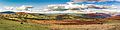
A view from beside the B4560 road south of Llangynidr. From left to right: the Brecon Beacons massif, Tor y Foel, Allt yr Esgair behind Buckland Hill (centre), Mynydd Troed behind Mynydd Llangorse with Myarth in the foreground, and the western part of the Black Mountains massif in the distance.
See also
 In Spanish: Brecon Beacons para niños
- Brecon Mountain Railway
- Brecon Beacons Food Festival
