Fforest Fawr facts for kids

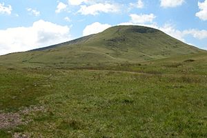
Fforest Fawr is a large, high area of land in Powys, Wales. Its name means "Great Forest" in Welsh. Long ago, it was a special hunting ground for kings. Today, people use it for grazing sheep, growing trees, collecting water, and enjoying nature. It is part of the beautiful Brecon Beacons National Park.
Contents
What is Fforest Fawr?
Fforest Fawr stretches from the Black Mountain in the west. It goes east towards the A470 road, which runs between Brecon and Merthyr Tydfil. This area is just west of the main Brecon Beacons mountains.
Famous Peaks in Fforest Fawr
This region includes several tall mountains. Some of the highest peaks are:
- Fan Fawr (734 meters)
- Fan Frynych (629 meters)
- Craig Cerrig-gleisiad (629 meters)
- Fan Llia (632 meters)
- Fan Nedd (663 meters)
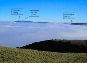
- Fan Gyhirych (725 meters)
- Fan Bwlch Chwyth (603 meters)
- Cefn Cul (562 meters)
Sometimes, people also include Fan Hir and Fan Brycheiniog as part of Fforest Fawr. However, when people talk about Fforest Fawr for fun activities, they usually mean the area east of the Black Mountain.

The Rocks and Land of Fforest Fawr
The ground in Fforest Fawr is mostly made of sandstones and mudstones. These rocks are part of something called the Old Red Sandstone. The stronger sandstone layers, known as the Brownstones Formation, form the highest peaks.
Different Rock Layers
South of the main peaks, you'll find two more rocky slopes. One is made of Carboniferous Limestone. Further south, there's the Twrch Sandstone, also known as Basal Grit or Millstone Grit. All these rock layers tilt southwards. They lead into the important South Wales Coalfield basin.
How the Land Was Shaped
The area has many cracks in the Earth's crust called faults. There are two main types of faults here.
- Two large faults, the Cribarth and Neath Disturbances, run from northeast to southwest. They are linked to the Variscan orogeny, a time when mountains were formed.
- Another group of faults runs from north-northwest to south-southeast. You can see these more clearly in the limestone and Millstone Grit areas.
Fforest Fawr was also covered by ice during the ice ages. This ice carved out bowl-shaped hollows called cirques. Craig Cerrig-gleisiad is a very impressive example. You can also see amazing landslides at Craig Cerrig-gleisiad and on the eastern slopes of Fan Dringarth.
Ancient History of Fforest Fawr
Fforest Fawr is full of ancient monuments from long ago. You can find two famous standing stones here: Maen Llia and Maen Madoc. Both are close to the old Roman road called Sarn Helen.
Traces of Early People
There are also remains of hut circles, stone circles, and stone rows. These show where people used to live. You can also see "pillow mounds." These are large earth mounds that were built to help farm rabbits on the moorland for their fur and meat.
Burial Mounds
You might also spot round barrows, which are usually stone piles called cairns. Some are on top of peaks, like on Fan Gyhirych. Others are found on the wild moorland. Most of these date back to the British Bronze Age (around 2000 BC) or even earlier. Not many have been fully studied by scientists. However, a cairn on Fan Foel was dug up in 2002-2004. Inside, they found a stone box with the ashes and bones of a woman and two children from about 2000 BC. They also found traces of meadowsweet flowers.
The Story of Fforest Fawr
Even though Fforest Fawr is open moorland today, it used to have many more trees. But the word "Fforest" in its name doesn't mean it was a dense forest. In the Middle Ages, a "forest" was a special area set aside for hunting. Only the local lord had the right to hunt animals there.
Royal Hunting Ground
Bernard de Neufmarche, a Norman lord of Brecon, created this hunting forest around the year 1100. Later, in the 13th century, another part of the highlands was added southwest of Sennybridge. To tell them apart, they were called Fforest Fach (Little Forest) and Fforest Fawr (Great Forest).
After the Norman Conquest, the Lord of Brecon owned the area. In 1521, it became the property of the Crown (the King or Queen).
Changes Over Time
In 1819, the Crown sold Fforest Fawr. This was done to raise money after the expensive Napoleonic Wars. A businessman named John Christie bought some of this land. He built a special railway track, called a tramroad, across the area from Sennybridge to Ystradgynlais. He hoped this would help farming, but his plan ran into money problems.
During the 1800s, some parts of Fforest Fawr were used for breeding rabbits. This was for both their fur and meat. The "pillow mounds" you see today, especially near Cefn Cul above Cray Reservoir, are the clearest signs of this project. These long, low earth mounds were built to give the rabbits places to burrow in the thin soil.
Since October 2005, Fforest Fawr has been the center of the Fforest Fawr Geopark. This was the first Geopark in Wales. Geoparks are special areas recognized for their amazing geological history.
How Fforest Fawr is Used Today

Today, Fforest Fawr is used for several important things.
Water and Trees
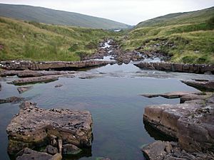
The waters of the Afon Dringarth river, which flows south, are collected in Ystradfellte Reservoir. This reservoir is located between Fan Fawr and Fan Llia. The waters of the Afon Crai river, which flows north, are stored in Cray Reservoir. This reservoir is just west of the A4067 road.
You can also see many conifer tree plantations on both the northern and southern slopes of Fforest Fawr.
Nature and Recreation
Fan Frynych and Craig Cerrig-gleisiad are protected as a national nature reserve. This area is managed by Natural Resources Wales. It is special because it has rare Arctic–alpine plants.
Almost all of Fforest Fawr is open for walkers to explore. A long walking trail, called the Beacons Way, goes through Fforest Fawr from east to west.
 | Jewel Prestage |
 | Ella Baker |
 | Fannie Lou Hamer |

