Brecon Beacons National Park facts for kids
Quick facts for kids Brecon Beacons National Park |
|
|---|---|
|
IUCN Category V (Protected Landscape/Seascape)
|
|
Sign entering Brecon Beacons National Park
|
|
| Location | United Kingdom (Wales) |
| Area | 1,344 km2 (519 sq mi) |
| Established | 1957 |
| Website | beacons-npa.gov.uk |
The Brecon Beacons National Park (Welsh: Parc Cenedlaethol Bannau Brycheiniog) is a special protected area in Wales. It is one of three national parks in Wales. The park is named after the Brecon Beacons hills. It also includes other important areas like the Black Mountain in the west, Fforest Fawr (meaning Great Forest) in the middle, and the Black Mountains in the east.
Contents
Discover the Brecon Beacons National Park
The Brecon Beacons National Park was created in 1957. It was the third national park in Wales. The first two were Snowdonia (1951) and the Pembrokeshire Coast (1952).
The park stretches a long way across southern Wales. It goes from Llandeilo in the west to Hay-on-Wye in the northeast. It also reaches Pontypool in the southeast. The park covers about 1,344 square kilometres (519 square miles).
Main Areas of the Park
The park has four main parts:
- The Black Mountain in the west. Its highest point is Fan Brycheiniog, which is 802 metres (2,631 feet) high.
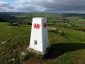
- Fforest Fawr and the Brecon Beacons in the centre. Here you'll find Pen y Fan, the highest mountain in the park and in South Wales. It stands at 886 metres (2,907 feet) tall.
- The Black Mountains in the east. The highest point here is Waun Fach, at 811 metres (2,661 feet).
In 2005, the western half of the park became a Fforest Fawr Geopark. This means it's a special area recognized for its important geology. In February 2013, the entire national park was named an International Dark Sky Reserve. This means it's a great place to see stars because there is very little light pollution.
Nature and Wildlife
Most of the park is covered in grassy moorland. Here, you can see Welsh mountain ponies and Welsh Mountain sheep grazing. There are also many forestry plantations and green pastures in the valleys.
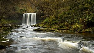
The park is famous for its quiet reservoirs and stunning waterfalls. One famous waterfall is the Henrhyd Waterfall, which is 27 metres (90 feet) high. You can also find many caves here, like Ogof Ffynnon Ddu.
The Brecon Beacons Mountain Centre opened in 1966. It helps visitors learn about and enjoy the park. Many birds live in the park, including Ravens, peregrine falcons, wheatears, ring ouzels, and the rare merlin. You might also spot the beautiful red kite.
Park Use for Training
Because some parts of the park are remote and have tough weather, they are sometimes used for military training exercises.
Fun Things to Do in the Park
The Brecon Beacons National Park is a fantastic place for outdoor activities! You can enjoy:
- Walking and cycling
- Mountain biking
- Horse riding
- Sailing and windsurfing
- Canoeing and fishing
- Rock climbing
- Hang-gliding
- Caravanning and camping
- Caving
There are also long routes for exploring the park. The Taff Trail is a cycling route that crosses the Beacons. It goes from Brecon to Cardiff. In 2005, a special walking route called the Beacons Way was opened. This 160-kilometre (100-mile) path goes across the entire park. It starts in Abergavenny and ends in the village of Llangadog in Carmarthenshire.
Brecon Mountain Railway
You can also ride a special narrow gauge train in the park. This train is run by the Brecon Mountain Railway. It's a fun way to see some of the beautiful scenery.
 | Kyle Baker |
 | Joseph Yoakum |
 | Laura Wheeler Waring |
 | Henry Ossawa Tanner |


