
Pen y Fan facts for kids
Quick facts for kids Pen y Fan |
|
|---|---|

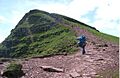
Pen y Fan from Cribyn
|
|
| Highest point | |
| Elevation | 886 m (2,907 ft) |
| Prominence | 672 m (2,205 ft) |
| Listing | Marilyn, Hewitt, Council top, Nuttall |
| Naming | |
| English translation | Top of the peak |
| Language of name | Welsh |
| Pronunciation | Welsh: [ˌpɛnəˈvan] |
| Geography | |
|
Pen y Fan
Location in Brecon Beacons
|
|
| Location | Powys, Wales |
| Parent range | Brecon Beacons |
| OS grid | SO012215 |
| Topo map | OS Landranger 160, Explorer OL12 |
Pen y Fan is the highest mountain in South Wales. It stands tall in the beautiful Brecon Beacons National Park, also known by its Welsh name, Bannau Brycheiniog. This impressive peak reaches 886 metres (2,907 ft) above sea level. It is the highest point in Britain south of Cadair Idris in Snowdonia.
Pen y Fan is also the highest point of the old county of Brecknockshire. Today, it is part of the Powys council area. Pen y Fan and its nearby peak, Corn Du, were once called Cadair Arthur, which means 'Arthur's Seat'.
The National Trust owns the mountain and the land around it. They work hard to protect the paths from wear and tear caused by many walkers. The UK's Special Forces also use the mountain for tough training exercises. Sadly, in July 2013, three soldiers died during a test march as part of their Special Forces training.
Contents
What's in a Name?
The name Pen y Fan comes from the Welsh language. Pen means 'top' or 'peak'. Y means 'the'. And fan is a changed form of ban, which means 'summit' or 'beacon'. So, Pen y Fan can mean 'the top of the peak' or 'the mountain's peak'.
You can also find the word ban in the Welsh name for the Brecon Beacons: Bannau Brycheiniog. This means 'the peaks of Brycheiniog'. Long ago, Pen y Fan was sometimes just called the 'Brecknock Beacon'.
Walking and Exploring
Pen y Fan is a popular spot for walkers and hikers. It is a main point on the Beacons Way, a long walking path that crosses the mountain range. Everyone is welcome to explore its trails.
There are good, easy-to-follow paths from places like Storey Arms and Pont ar Daf. These spots are on the A470 road, about 460 metres (1,510 ft) below the summit. The National Trust works hard to fix and maintain these paths. This helps to stop erosion from the hundreds of thousands of people who walk here every year. You can also find a major path leading from Cribyn, another nearby peak to the east.
The Summit Views

The top of Pen y Fan is part of a long, wavy ridge. This ridge stretches from the Talybont Reservoir in the east to the A470 road. About 0.5 km (0.3 mi) to the southwest is Corn Du, a slightly lower peak. From there, the land slopes down to Y Gyrn, and then more steeply to the Storey Arms on the A470.
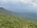
To the east, the ridge drops sharply to a low point that connects Pen y Fan to Cribyn. On a clear day, the views from the summit are amazing! You can see the Bristol Channel, Carmarthen Bay, and even the Gower Peninsula. You might also spot the Black Mountains, the Cambrian Mountains, and the town of Brecon.
Weather on the Mountain
Pen y Fan has a climate similar to many high areas in Wales. Snow can fall between November and May, but how much snow and how long it stays changes each year. After a big snowfall, the mountain becomes a fun place for local skiing fans.
Ancient History at the Top
The very top of Pen y Fan has a reconstructed Bronze Age cairn. A cairn is a pile of stones. This one has a stone cist in the middle. A cist is like a stone box made of flat slabs. It would have held the ashes or remains of people who lived long ago. People often buried items like flint tools or special pots with the dead. This is similar to the cairn on nearby Corn Du.
How the Mountain Was Made
Pen y Fan is made from different types of Old Red Sandstone. These rocks were formed during the Devonian period, millions of years ago. The lower parts of the mountain are made of sandstones and mudstones. The very top, like Corn Du, is made of very strong sandstones.
During the last ice age, glaciers formed on the Brecon Beacons. These glaciers carved out valleys like Cwm Llwch and Cwm Sere. Llyn Cwm Llwch is a lake that sits in a hollow dug out by a glacier.
Pen y Fan is the highest point in the Fforest Fawr Geopark. This park was created in 2005 to help the area's economy. It does this by promoting sustainable tourism based on the amazing geology of the region.
Tommy Jones' Obelisk

Above Cwm Llwch, on a ridge of Corn Du, you'll find a granite obelisk. An obelisk is a tall, four-sided stone pillar. This one is a memorial with a sad story. It marks the spot where a five-year-old boy named Tommy Jones was found.
Tommy got lost on August 4, 1900, while visiting his grandparents. After a 29-day search, his body was found on September 2nd. He had died from exhaustion and cold. How such a young boy climbed so high remains a mystery. The obelisk is a useful landmark for walkers, especially when it's foggy. It was paid for by donations from people who felt sad about Tommy's story.
Storey Arms Outdoor Centre
The Storey Arms is an outdoor education centre located next to the A470 road. This road is a main route through the Brecon Beacons National Park. The centre is near the village of Libanus, Powys, Wales. Cardiff City Council has run it since 1971.
The centre can host up to 58 people and offers many exciting activities. These include kayaking, canoeing, caving, hill walking, rock climbing, and white water rafting. It sits 440 metres (1,444 ft) above sea level, between Pen y Fan and Fan Fawr. The centre gets its name from an old inn that used to be there, named after a local landowner.
The car park at Pont ar Daf is very popular for people wanting to walk up Pen y Fan. It's about 200 metres (656 ft) from the Storey Arms centre. The car park has space for about 200 cars and is managed by the National Trust. There are also composting toilets available. A footpath connects the Storey Arms, bus stops, and the car park to the main path leading up to Corn Du and Pen y Fan.
Images for kids
-
The summit
-
Llyn Cwm Llwch (lake) viewed from Pen Y Fan


| Listed summits of Pen y Fan | ||||
| Name | Grid ref | Height | Status | |
|---|---|---|---|---|
| Corn Du | SJ066318 | 873 metres (2,864 ft) | sub Hewitt, Nuttall | |
| Cribyn | SJ066318 | 795 metres (2,608 ft) | Hewitt, Nuttall | |
| Y Gyrn | SJ066318 | 619 metres (2,031 ft) | sub Hewitt, Nuttall | |
