
Black Mountains, United Kingdom facts for kids
The Black Mountains are a cool group of hills found in parts of Powys and Monmouthshire in southeast Wales. They also stretch a little bit into Herefordshire, England. These hills are the most eastern part of the four main hill ranges that make up the amazing Brecon Beacons National Park.
Sometimes, people get the Black Mountains mixed up with another range called the Black Mountain, which is much further west. To help you picture them, the Black Mountains are roughly shaped like a triangle. The towns of Abergavenny (in the southeast), Hay-on-Wye (in the north), and the village of Llangors (in the west) mark its corners. Other nearby towns that are great starting points for exploring include Talgarth and Crickhowell.

Walkers and hikers love the Black Mountains because it's easy to get around. There are many trails along the ridges, like the one on Black Hill in Herefordshire. This area also has the highest public road in Wales, called Gospel Pass. Plus, Black Mountain itself is the highest point in southern England!
Contents
What's in a Name?
The name "Black Mountains" has an interesting history. Long ago, a historian named John Leland wrote about a "Blak Montayne." He was talking about a much bigger area that included what we now call the Brecon Beacons. This even included the other "Black Mountain" range far to the west.
The Welsh name for these hills is traditionally Y Mynydd Du, which means 'the black mountain'. More recently, people have started using Y Mynyddoedd Duon, meaning 'the black mountains'. This is a retranslation from the English name.
Exploring the Mountains
The tallest mountain in this group is Waun Fach. Its top is covered in peat and is about 811 metres (2,661 feet) high. Another important peak is Pen y Gadair Fawr, which is 800 metres (2,625 feet) tall and has a more distinct shape.

On the eastern side, the peak of Black Mountain is 703 metres (2,306 feet) high. It sits right on the border between Wales and England. This makes it the highest point in England south of a mountain called Great Whernside in Yorkshire.
Other tall peaks in the north include Hay Bluff (also known as Penybegwn in Welsh) at 677 metres (2,221 feet), Rhos Dirion at 713 metres (2,339 feet), and Lord Hereford's Knob or Twmpa at 690 metres (2,264 feet).
Towards the south, you'll find more separate mountains like Crug Mawr (550 metres or 1,804 feet), Pen Allt-mawr (719 metres or 2,359 feet), and Pen Cerrig-calch (701 metres or 2,300 feet). Pen Cerrig-calch stands out above the town of Crickhowell.
Some other well-known hills in the area are the Sugar Loaf (Pen-y-Fal in Welsh), Mynydd Troed, and Mynydd Llangorse. You can also find smaller, separate hills like Allt yr Esgair, Myarth, Bryn Arw, and Ysgyryd Fawr (also called 'The Skirrid' or 'Holy Mountain') scattered around the southern edge of the Black Mountains.
How the Mountains Were Formed
Bedrock: The Old Red Sandstone
The Black Mountains are mostly made of rocks called Old Red Sandstone. These rocks formed during a time called the Devonian period. This period was millions of years ago! These rocks are a mix of sandstones, mudstones, siltstones, and thin layers of limestones.
The lower parts of the hills are made from a type of mudstone. Above that, you'll find sandstone that forms the higher parts of the range. The very tops of the central and southern mountains are made of even higher sandstone layers.
The red color of these rocks comes from iron oxide, which is like rust. But not all the rocks are red; some can be grey, green, or even purple!
Glaciers and Landslides
During the Ice Ages, huge sheets of ice covered much of Britain. The Black Mountains were at the edge of these ice sheets. The ice didn't start here, but it flowed in from central Wales. This ice helped shape the valleys, making their sides very steep.

Because the valley sides became so steep, many landslips (or landslides) have happened over time. You can see some impressive ones in the Vale of Ewyas. One of the most famous is at Darren and Cwmyoy. Another big landslide can be seen at the northern end of the Skirrid mountain, near Abergavenny. These landslides show how powerful nature can be!
What People Used the Rocks For
You can find many small, old quarries scattered around the Black Mountains. These quarries are now abandoned, but long ago, people dug out stone from them. This stone was used to build walls and roofs for local homes.
Sometimes, the thin limestone layers were also dug up. This limestone was then heated in special ovens called limekilns to make lime. Lime was used to help farms grow crops better and also in building houses. The red sandstone from these mountains has been used in many buildings across Wales and Herefordshire.
Fun Things to Do in the Black Mountains
The Black Mountains are a fantastic place for outdoor activities!
- Walking and Hiking: Many people love to go hiking here.
- Biking: It's also popular for mountain biking.
- Horse Riding: You can even go horse riding on some trails.
Several long-distance walking paths pass through the area. The Offa's Dyke National Trail follows the border between England and Wales. The Beacons Way and the Marches Way also go through the Black Mountains. If you like horse riding, the Three Rivers Ride runs along the northern slopes.

The northern cliffs of the range are great for gliding, hang gliding, and paragliding. This is because the wind gets pushed up and over the hills, which is perfect for these sports!
Cool Places to Visit
There are several small villages and interesting spots in the Black Mountains.
- Old Pub: The The Skirrid Mountain Inn is said to be the oldest pub in Wales, with records going back to the year 1100!
- Historic Buildings: You can visit the ruins of Llanthony Priory in the Vale of Ewyas, or the ruined Craswall Priory. There's also Tretower Castle and Tretower Court, which are old buildings with lots of history.
- Ancient Forts: Check out the Iron Age hill fort of Crug Hywel. You can also see the remains of Castell Dinas, an old castle built on the site of an even older Iron Age hillfort.
- Churches: The churches at Cwmyoy and Partrishow are also worth seeing.

- Hay-on-Wye: Just north of the mountains is Hay-on-Wye, often called the "town of books." It was the very first "booktown" ever, and it has more than twenty-four second-hand bookshops! It's a paradise for book lovers.

Towns and Villages Nearby
Some of the towns and villages in and around the Black Mountains include:
- Hay-on-Wye
- Llangors
- Talgarth
- Crickhowell
- Cwmdu (all in Powys)
- Abergavenny (in Monmouthshire)
- Longtown (in Herefordshire)
Many of these places are great starting points for exploring the hills all year round.
Artists and Writers
The Black Mountains have inspired many creative people.
- The famous artist and typeface designer Eric Gill lived in Capel-y-ffin from 1924 to 1928.
- The artist and poet David Jones also worked in the area during the same time.
Books About the Black Mountains
Several books are set in or around the Black Mountains, bringing the landscape to life:
- People of the Black Mountains by Raymond Williams
- On The Black Hill by Bruce Chatwin (which was also made into a film)
- Resistance by Owen Sheers (also adapted as a film)
- Running for the Hills: a family story by Horatio Clare
Images for kids
-
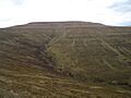
Waun Fach from Mynydd Llysiau.
-
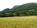
The large landslip at the north end of the Skirrid.
-
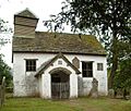
St Mary's Chapel at Capel-y-ffin.


