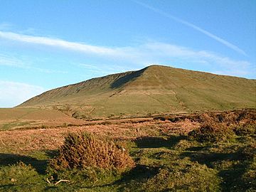
Hay Bluff facts for kids
Quick facts for kids Hay Bluff |
|
|---|---|

Hay Bluff viewed from the north
|
|
| Highest point | |
| Elevation | 677 m (2,221 ft) |
| Prominence | 11 m (36 ft) |
| Listing | Deleted Nuttall |
| Geography | |
| Location | Powys, Wales |
| Parent range | Black Mountains |
| OS grid | SO24433662 |
Hay Bluff (in Welsh: Penybegwn) is a well-known hill located at the northern end of the Black Mountains. This is a large area of high land that sits on the border between south-east Wales and England. The hill is where the main steep slope (called an escarpment) of the Black Mountains, which faces northeast, meets another slope facing northwest. The next peak to the west of Hay Bluff is Twmpa.
The top of Hay Bluff is flat and has a special marker called a triangulation pillar. It stands at 677 metres (2,221 feet) high. From the summit, you can look down over the middle Wye Valley and the famous book town of Hay-on-Wye. Most of Hay Bluff is in the Welsh county of Powys, but some parts on its eastern side are in the English county of Herefordshire.
What Hay Bluff is Made Of
The lower and main parts of Hay Bluff are made from a type of rock called mudstone. This rock is part of something called the St Maughans Formation. The upper part of the hill is made from sandstones and more mudstones, which are known as the Senni Formation. Both of these rock types belong to the Old Red Sandstone, which formed a very long time ago during the Devonian period.
In the past, people used to dig in small quarries on the slopes of Hay Bluff. They were looking for a special type of rock called Ffynnon Limestone. This rock is a kind of calcrete (a hard layer of calcium carbonate) that can be found along the northeastern and northwestern sides of the hill, at the bottom of the Senni Formation.
How to Explore Hay Bluff
Many people enjoy walking on Hay Bluff. The famous Offa's Dyke national trail goes up the steep northern slopes of the hill. From there, it heads southeast along the wide ridge of the Black Mountain and the Hatterrall Ridge.
If you prefer an easier walk to the top, you can follow a gentler path. This path goes along the top of the northwest-facing slope, known as Ffynnon y Parc. It starts from the road summit about 1.7 kilometres (1 mile) southwest at Gospel Pass.
There is also a clear, unpaved path that runs along the edge of the eastern slope. This path offers great views over the countryside towards Hay-on-Wye. It leads to the trig point at the Black Hill (Herefordshire) and then continues southeast, going down a stony, narrow ridge towards Longtown. You can find a small car park where the ridge drops into the Olchon valley, about 3.2 kilometres (2 miles) north of Longtown.
The entire area of Hay Bluff is considered "open country." This means that walkers have the freedom to roam and explore almost anywhere they wish.
 | Kyle Baker |
 | Joseph Yoakum |
 | Laura Wheeler Waring |
 | Henry Ossawa Tanner |

