Hatterrall Ridge facts for kids
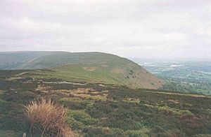
The Hatterrall Ridge is a long hill range in the Black Mountains. It forms part of the border between Wales (specifically Powys and Monmouthshire) and England (specifically Herefordshire). This ridge stretches for about 10 miles (16 kilometers). A famous walking trail called the Offa's Dyke Path follows its entire length.
On the west side of the ridge, you'll find the beautiful Vale of Ewyas. To the east, there's the Olchon Valley and Black Hill. The western part of the ridge is inside the Brecon Beacons National Park. While the northern part of the ridge is wide and rounded, it becomes much narrower further south. Near Llanthony Priory, on the western side, there's a big landslip called Black Darren. Here, a large piece of the hillside has broken away. The ridge also ends sharply at a cliff called the Darren, with more landslips below it, reaching towards the small village of Cwmyoy.
High Points of the Ridge
The highest point on the Hatterrall Ridge is a hill called Black Mountain. It stands at 2,306 feet (703 meters) tall and is located near the northern end of the ridge. Closer to the southern end, you'll find Hatterrall Hill, which is 1,742 feet (531 meters) high.
The ground around the main path can be quite wet and boggy due to peat. However, the walking path itself is usually dry and stony. As you go further south, the lower parts of the ridge are covered in grass and heath, making them generally drier than the higher, open moorland. Much of the ridge is common land, meaning it's not fenced. This allows Welsh ponies and sheep to roam and graze freely across large areas.

Exploring the Ridge
The Offa's Dyke Path is the main route along the Hatterrall Ridge, running from south to north. You can also reach the top from the Vale of Ewyas on the west side, near where an old youth hostel used to be. The path along the ridge is well-marked and has a good surface. Stone pavements are used in very wet areas to keep walkers dry.
The very top of the ridge is flat and wide, so it's hard to tell exactly where the highest point is without special equipment. However, there are several helpful landmarks along the way. These include a trig point (a marker used for surveying), signposts, and stone cairns (piles of stones). Many smaller footpaths and bridleways cross the main ridge path. These side paths let you explore both the Vale of Ewyas to the west and the Olchon Valley to the east. This means you can plan many different circular walks.
The moorland on the ridge is considered open access land. This means you are allowed to walk off the marked paths, but be aware that the ground can be peaty and wet, especially at higher elevations. The ridge is also common land, where sheep, ponies, and cattle graze.
The ridge is a popular spot for paragliding and hang gliding. People enjoy flying here when the wind comes from the east or east-north-east.
How the Ridge Was Formed
The Hatterrall Ridge is made up of sedimentary rocks. These are sandstones and mudstones from a geological period called the Devonian age. These rocks are part of something called the Senni Formation of the Old Red Sandstone. You can often see the layers of these rocks in old quarries or along the steep slopes (called escarpments) on either side of the ridge.
The layers are most clear where landslips have happened. Here, softer rocks have worn away, making the rocks above them unstable. There are many small, old quarries on the slopes, but they are all closed now. The shape of the Vale of Ewyas on the west and south sides of the ridge suggests that a glacier once filled this valley. This likely happened during an ice age, though probably not the very last one. The flat top of the ridge itself was probably not covered by ice.
Animals of the Ridge
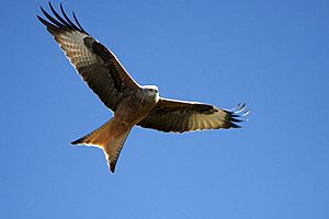
The Hatterrall Ridge is home to many different types of birds. Larger birds you might see include the red kite, the common buzzard, the raven, and the carrion crow. On the lower slopes, you'll often spot rabbits. Foxes and badgers also live here.

 | Aurelia Browder |
 | Nannie Helen Burroughs |
 | Michelle Alexander |

