
Hatterrall Hill facts for kids
Quick facts for kids Hatterrall Hill |
|
|---|---|

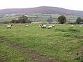
Hatterrall Hill viewed from the east
|
|
| Highest point | |
| Elevation | 531 m (1,742 ft) |
| Geography | |
| Location | Wales-England border |
| Parent range | Black Mountains |
| OS grid | SO308256 |
Hatterrall Hill (which is called Welsh: Mynydd Y Gader in Welsh) is a rounded mountain peak. It is part of the Black Mountains range. This hill sits right on the Wales-England border. Part of it is in Monmouthshire, Wales, and part is in Herefordshire, England.
The very top of Hatterrall Hill is 531 meters high. This top part is a flat, boggy area called a plateau. It drops down steeply on all sides. Long, wide ridges stretch out from the hill to the north, southeast, and southwest.
To the north, the ridge is known as Hatterrall Ridge. It dips down to a low point (called a col) at about 485 meters. From there, it slowly rises over several kilometers. It leads towards other peaks like Crib y Garth, Black Hill, and Hay Bluff.
The ridge to the southwest ends suddenly at a steep rock face called the Darren. Below this cliff, there is a large area where the ground has slipped down. This area stretches south to a small village called Cwmyoy. This village is famous for its unusually shaped church. The part of Hatterrall Hill that is in Wales is inside the Brecon Beacons National Park.
Exploring Hatterrall Hill
The higher parts of Hatterrall Hill are open for everyone to explore. This means that walkers can freely go hiking there. Many public footpaths and other walking routes lead onto this open land. You can reach the hill from the Vale of Ewyas (also known as the Llanthony Valley) to the west. You can also get there from the Monnow valley to the east.
Two famous long-distance walking paths cross over Hatterrall Hill. The Offa's Dyke Path runs from north to south across the hill. The Beacons Way also follows a similar route here. These paths are great for long hikes and offer amazing views.
What Hatterrall Hill is Made Of
Hatterrall Hill is made up of different types of rock. These rocks are mostly sandstones and mudstones. They belong to a rock layer called the Senni Beds Formation. These rocks are part of the Old Red Sandstone group. They were formed a very long time ago, during the Devonian period. This period was about 419 to 359 million years ago.
You can see many small, old quarries on the slopes of the hill. Quarries are places where rocks were once dug out of the ground. All of these quarries are now empty and no longer used. During the ice ages, huge sheets of ice called glaciers filled the Vale of Ewyas. However, the flat top of Hatterrall Hill probably stayed free of ice.
Images for kids
-
Hatterrall Hill viewed from the east
