Twmpa facts for kids
Quick facts for kids Twmpa/Lord Hereford's Knob |
|
|---|---|
 |
|
| Highest point | |
| Elevation | 690 m (2,260 ft) |
| Prominence | 79 m (259 ft) |
| Parent peak | Waun Fach |
| Listing | Hewitt, Nuttall |
| Geography | |
| Location | Powys, Wales |
| Parent range | Black Mountains |
| OS grid | SO224350 |
| Topo map | OS Landranger 161 |
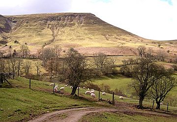
Twmpa, also known as Lord Hereford's Knob, is a mountain located in southeast Wales. It's part of the Black Mountains, which are famous for their beautiful scenery. This mountain is like a big, steep slope, forming part of the Black Mountains' northwest edge. Twmpa is about 3 kilometers (1.86 miles) west of the border with England. It's also about 7 kilometers (4.34 miles) south of a town called Hay-on-Wye. To the northeast of Twmpa, you'll find the Gospel Pass. This pass has a small road that connects Hay-on-Wye to the Llanthony Valley. There's also a ridge called Darren Lwyd that stretches about 3 kilometers (1.86 miles) southeast from the top of Twmpa.
Mountain Rocks: What Twmpa is Made Of
Just like the hills nearby, Twmpa is made up of different layers of rock. These layers include sandstone and mudstone. These rocks were formed a very long time ago, during a period called the Devonian period. They are part of what geologists call the Lower Old Red Sandstone.
The lower parts of Twmpa are mostly made of a type of mudstone called the St Maughans Formation. As you go higher up the mountain, the rocks change. The upper parts are made of a sandstone-heavy rock called the Senni Formation. Right where these two rock types meet, there's a special layer. It's a hard, chalky layer known as the Ffynnon Limestone.
Over time, many landslides have happened on the slopes of Twmpa. These landslides mostly occur in the St Maughans Formation, which is the mudstone layer.
Exploring Twmpa: How to Visit
Twmpa is a great place for hikers and nature lovers to explore! The entire mountain is considered "open country" under a special law called the CRoW Act. This means that people can freely walk and roam across the whole hill.
There are many paths around Twmpa that you can use. These include public bridleways and restricted byways. The most popular path starts from Gospel Pass, where you can park your car. From there, the path goes west, right over the top of Twmpa. It then continues southwest towards a place called Rhos Dirion. Another path follows the ridge southeast, leading to a small village called Capel-y-ffin.
 | Claudette Colvin |
 | Myrlie Evers-Williams |
 | Alberta Odell Jones |

