Sugar Loaf, Monmouthshire facts for kids
Quick facts for kids Sugar Loaf |
|
|---|---|
| Mynydd Pen-y-fâl | |

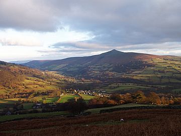
The Sugar Loaf from the north-west, with the village of Llanbedr in the valley below
|
|
| Highest point | |
| Elevation | 596 m (1,955 ft) |
| Prominence | 411 m (1,348 ft) |
| Parent peak | Waun Fach |
| Listing | Marilyn |
| Geography | |
| Location | Monmouthshire, United Kingdom |
| Parent range | Black Mountains |
| OS grid | SO272187 |
| Topo map | OS Landranger 161 |
The Sugar Loaf (Welsh: Mynydd Pen-y-fâl) is a famous hill. It is located about 2 miles (3.2 km) north-west of Abergavenny in Monmouthshire, Wales. This beautiful hill is part of the Brecon Beacons National Park.
It is the most southern peak of the Black Mountains. The Sugar Loaf stands tall at 1,955 feet (596 metres). A brave woman named Lady Rhondda gave the Sugar Loaf to the National Trust. She was a suffragette, meaning she fought for women's right to vote.
Contents
What's in a Name?
The Sugar Loaf has a long history with its name. It was first called Y Fâl, which means "the peak" in Welsh. Its unique top was known as Pen y Fâl, meaning "top of the peak".
Today, its Welsh name is Mynydd Pen-y-fâl. This means "mountain of the top of the peak". The name "Sugar Loaf" started being used in the 1700s. Many other mountains around the world share this name. They are all named because they look like old-fashioned sugarloaves. These were cone-shaped blocks of sugar.
Ancient History of Sugar Loaf
In the 1990s, scientists made an exciting discovery. They found ancient flint tools on a southern part of the hill called Y Graig. These tools show that people lived here a very long time ago.
The tools date back to different periods. These include the Mesolithic (Middle Stone Age), Neolithic (New Stone Age), and Bronze Age. This means people were using the area for thousands of years.
How Sugar Loaf Was Formed
Many people think the Sugar Loaf is an extinct volcano. This is because its shape looks like a classic volcano, especially from the east. However, this is not true!
The hill is actually made of sedimentary rocks. These rocks formed from layers of sand and mud over millions of years. The Sugar Loaf is part of the Old Red Sandstone rock group. This rock formed during the Devonian Period, a very long time ago.
The lower parts of the hill are made of mudstones and sandstones. The very top of the Sugar Loaf is made of a harder rock called Quartz Conglomerate. You can also see some landslips on its sides. These are places where parts of the hill slid down. They likely happened after the last Ice Age.
Nature and Land Use
Most of the Sugar Loaf is owned by the National Trust. They help protect the land and its wildlife. Welsh mountain sheep graze on the slopes, keeping the grass short.
The lower parts of the hill have deciduous forests. These are trees that lose their leaves in autumn. Higher up, you'll find plants like fern, heather, and bilberry. Bilberries are small, tasty fruits, known locally as whinberries. The wooded slopes are a special protected area called a Site of Special Scientific Interest.
There is even a vineyard at the foot of the mountain. It's called Dummar Farm. They grow grapes and make Sugar Loaf wine.
Exploring the Summit
The Sugar Loaf is a very popular spot for walkers. Many people enjoy hillwalking here. You can start your climb from the Sugar Loaf car park, which is already quite high up. Or, you can take a longer walk from towns like Abergavenny, Crickhowell, or Llangenny.
From the top, you get amazing views! You can see the Black Mountains to the north. To the east, you might spot the Cotswolds. Look west, and you'll see parts of the Brecon Beacons, including Pen y Fan and Corn Du. On a clear day, you can even see the Bristol Channel to the south. You can also easily spot the Skirrid mountain nearby.

