
Offa's Dyke facts for kids


Offa's Dyke (in Welsh: Clawdd Offa) is a very old and long earth wall. It mostly follows the border we have today between England and Wales.
This amazing structure is named after King Offa. He was a powerful king of Mercia, an old kingdom in England, back in the 8th century. Many people believe he ordered it to be built. We aren't completely sure why it was built, but it followed the border between his kingdom and the Welsh kingdom of Powys.
The dyke was huge! It could be up to 65 feet (20 meters) wide, including its ditch, and 8 feet (2.4 meters) high. It went over all kinds of land, like low areas, hills, and even rivers. Today, this ancient earthwork is a protected historical site, called a scheduled monument.
The Offa's Dyke Path
There is a famous walking route called the Offa's Dyke Path. It's a very long footpath, 176 miles (283 km) in total. It stretches from Prestatyn in North Wales (near Liverpool Bay) all the way down to Sedbury, close to Chepstow (near the Severn Estuary) in South Wales.
This path runs near the original Offa's Dyke for much of its journey. It is a special British National Trail, which means it's a well-known and protected route for walkers to enjoy.
Protecting the Dyke
Many parts of Offa's Dyke are very important for nature and history. Some sections are called Sites of Special Scientific Interest. This means they are special places for plants, animals, or geology. Other parts are in Areas of Outstanding Natural Beauty. These are places with beautiful landscapes.
Most of the dyke's path is also a Public Right of Way. This means people are allowed to walk along it, including the sections that are part of the Offa's Dyke Path. It's important to protect these ancient sites for everyone to learn from and enjoy.
In August 2013, a small part of the dyke, about 45 meters long, was damaged near Chirk and Llangollen. This damage was a reminder of how important it is to protect these historical treasures. Damaging such an old monument is like damaging a very famous landmark, showing how much we value our history.
Images for kids
-
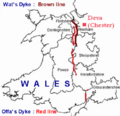
Wat's Dyke in brown; Offa's Dyke in red


See also
 In Spanish: Muralla de Offa para niños
