
Knighton, Powys facts for kids
Quick facts for kids Knighton
|
|
|---|---|
 Broad Street |
|

Knighton
|
|
| Population | 3,033 (2020) |
| - in Powys: | 2,909 |
| - in Shropshire: | 124 |
| OS grid reference | SO286723 |
| Civil parish |
|
| Community |
|
| Principal area | |
| Unitary authority |
|
| Ceremonial county | |
| Ceremonial county | |
| Region | |
| Country | Wales England |
| Sovereign state | United Kingdom |
| Post town | Knighton |
| Postcode district | LD7 |
| Dialling code | 01547 |
| Police | Dyfed-Powys |
| Fire | Mid and West Wales |
| Ambulance | Welsh |
| West Midlands | |
| EU Parliament | Wales West Midlands |
| UK Parliament |
|
| Welsh Assembly |
|
Knighton is a small market town located right on the border between Wales and England. It sits on the River Teme. Its Welsh name is Tref-y-clawdd, which means 'town on the dyke'. This makes sense because the town is built near Offa's Dyke, an ancient earth wall that once separated the two countries. Long ago, Knighton was an Anglo-Saxon village and later a Norman border town, built to defend the area.
Contents
What's in a Name?
The Welsh name for Knighton, Tref-y-clawdd, means 'town on the dyke'. This name was first written down in 1262 and officially given to the town in 1971.
The name Knighton likely comes from old English words. 'Cniht' meant a soldier or free person, and 'tūn' meant a farm or settlement. So, the town might have been started by giving land to free people.
Knighton's Past
Knighton has a long and interesting history. Not far from the town is Caer Caradoc, an Iron Age hill fort. This fort is linked to an ancient British leader called Caratacus. Also, a famous Roman road called Watling Street passes nearby.
Knighton has a well-preserved part of Offa's Dyke. This huge earth wall was built long ago to mark the border between England and Wales. There are also two old Norman castle mounds in Knighton, built in the 12th and 13th centuries. These are the oldest buildings still standing.
Knighton became a special town in 1203 when it received a charter. This allowed it to hold a weekly market and an annual fair.
One of the castles in Knighton was captured and destroyed in 1262 by Llewelyn ap Gruffyd, a Welsh prince. Later, in 1402, the Welsh leader Owain Glyndŵr attacked the remaining castle and much of the town. A big battle during his rebellion, the Battle of Pilleth, happened just a few miles from Knighton.
.jpg)
.jpg)
The town's church was first built in the 11th century, but most of it was rebuilt in the 1800s. It is one of only two churches in Wales dedicated to St Edward, who was England's patron saint before St George. This shows how Knighton has always had strong links to both England and Wales. It wasn't until 1535 that Knighton was officially confirmed as part of Wales.

Knighton grew wealthy in the 1400s because of the wool trade. It was also an important stop for drovers, who moved animals like sheep and cattle along old routes.
The railway came to Knighton in 1861. Local landowners and business people helped build the line to connect the town to bigger cities. This was a big deal for Knighton, as it was quite a remote place.
In 1953, to celebrate Queen Elizabeth II becoming queen, the letters "ER" were planted using different types of trees on a hill north of the town.
In 1970, Knighton even hosted a rock festival with famous bands and musicians!
How Knighton is Run

Knighton has a fire station with a part-time crew. The local police force is Dyfed-Powys Police.
The town has a hospital, but it doesn't have an accident and emergency department. There is also a local doctor's office and a pharmacy.
Knighton is twinned with a small town in France called Varades. This means they have a special friendship and often visit each other.
People of Knighton
Knighton's population was estimated to be around 2,912 people in 2019. The town has grown slowly since the early 1800s.
People in Knighton are less likely to say they are Welsh compared to people in other parts of Wales. The town also has a very low unemployment rate.
Fun Things to Do in Knighton
The town has visible remains of its two old castle mounds. The Clock Tower in the town was built in 1872.
Every year, on the last Saturday in August, Knighton usually holds a big Carnival and Show. People come from all over to see the parades with themed floats and people in fancy dress. The show takes place at the town's showground, which is also home to local sports clubs.
Just outside Knighton, you can see an observatory with a telescope. It also has Europe's largest camera obscura and a planetarium. This is part of a project called Spaceguard UK, which looks for asteroids in space.
Knighton is a great place for walkers! Two famous long-distance paths, Glyndŵr's Way and Offa's Dyke Path, pass through the town. The Offa's Dyke Association has a visitors' centre in Knighton.
Sports in Knighton

Knighton has teams for rugby, cricket, football, and hockey. There's also a nine-hole golf course designed by a famous golfer, Harry Vardon, in 1906.
Knighton Town F.C. plays in the Mid Wales League. The town also has a swimming pool and leisure centre.
In 2009, Knighton hosted a round of the British Enduro Championship (a type of motorcycle race). The Tour of Britain cycle race also passed through Knighton in 2014.
Famous People from Knighton
- Alfred Edwards (1850–1923) helped start the famous Italian football club A.C. Milan.
- Kenneth Turpin (1915–2005) was a leader at the University of Oxford.
- Ron Powell (1929–1992) was a football goalkeeper who played over 500 games.
- Dick Heckstall-Smith (1934–2004) was a famous saxophonist and composer who grew up nearby.
- Emma Manners, Duchess of Rutland (born 1963) was born and raised in the area.
- Ed James (born 1976) is a radio presenter.
- Chaz Davies (born 1987) is a motorcycle racer who was born in Knighton. He won the World Supersport championship in 2011.
Knighton's Economy
Knighton's shops serve the surrounding countryside and employ many people. However, there isn't much other industry in the town. Many young people leave Knighton after finishing school to find work elsewhere.
Tourism is very important for Knighton. The town's location means that most people who work there (about 70%) work within a 12-mile area.
Education in Knighton
Knighton has a primary school. For secondary school, students travel by bus to John Beddoes School in Presteigne, about 8 miles away.
Knighton's Location and Landscape

Knighton is about 137 miles from London, the capital of the UK, and 86 miles from Cardiff, the capital of Wales. It's about 19 miles from Llandrindod Wells, the county town of Powys.
The town is in a hilly area with narrow river valleys. To the west, the land rises steeply towards Radnor Forest. The town centre is about 174 meters (571 feet) above sea level, but the surrounding hills can reach up to 418 meters (1,371 feet). The main river is the River Teme.
Knighton is built on rocks from the Silurian Period, which is a very old geological time. The town was also near the edge of the ice sheet during the last ice age.
Knighton's Weather
Knighton has a slightly warmer and drier climate than the average for Wales. This is because it is in the "rain shadow" of the Cambrian Mountains, meaning the mountains block some of the rain.
In a very unusual event on August 18, 2004, fish reportedly fell from the sky in Knighton!
Getting Around Knighton
Knighton is located about 30 miles between Shrewsbury and Hereford, where the A4113 and A488 road meet.
Local bus services are limited.
Knighton railway station is on the Heart of Wales Line. Trains from here can take you directly to Shrewsbury and Swansea. The train station itself is actually just inside England, in Shropshire.
The closest international airport is Birmingham. Smaller planes can fly from Welshpool Airport and Shobdon Aerodrome.
Images for kids
-
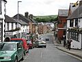
Broad Street
-
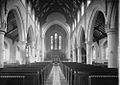
Knighton Church, 1910s
-
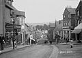
Broad St. Knighton, 1910s
-
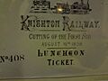
Arrival of the railway
-
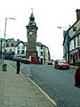
Clock Tower
-
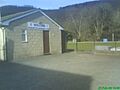
Bowling Club
-
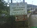
Entry to Knighton
-
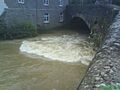
River Teme in spate

See also
 In Spanish: Knighton (Gales) para niños
