
Cambrian Mountains facts for kids
.jpg)

The Cambrian Mountains (called Mynyddoedd Cambria in Welsh) are a group of mountain ranges in Wales.
Long ago, the name "Cambrian Mountains" was used for most of the high lands in Wales. But since the 1950s, it mainly refers to the hills in Mid Wales. This area is known as Elenydd in Welsh. It stretches from Pumlumon to Radnor Forest in the east and Mynydd Mallaen in the south. This wild and quiet area is sometimes called the Desert of Wales.
Important rivers like the River Severn and River Wye start here. In the 1960s and 1970s, people suggested making this area a national park, but it didn't happen. The highest point in this part of the range is Plynlimon, which is about 2,467 feet (752 meters) tall.
The older, wider meaning of "Cambrian Mountains" also includes Snowdonia in North Wales. It also includes the Brecon Beacons and Black Mountains in South Wales. Mountains in Snowdonia can be as high as 3,559 feet (1,085 meters).
Contents
What are the Cambrian Mountains Made Of?

The mountains in Snowdonia have a mix of volcanic rocks and sedimentary rocks. These rocks were formed a very long time ago. The mountains in South Wales are mostly made of Old Red Sandstone and Carboniferous Limestone.
However, the mountains in Mid-Wales (the modern Cambrian Mountains) are different. They are mostly made of sandstones and mudstones. These rocks often don't stick out much, so the hills look more rounded and grassy.
These mountains get a lot of rain because they face the wind coming from the Atlantic Ocean. This is why many rivers start here. The River Severn and River Wye are two of the biggest rivers that begin on the eastern slopes of Pumlumon.
Dams and Wind Farms in the Mountains
The Cambrian Mountains are home to several large dams and reservoirs. These include the Elan Valley Reservoirs and Llyn Brianne reservoir. They store water for people living in the English West Midlands and South Wales. Other reservoirs here are the Clywedog Reservoir and Nant y Moch.
You can also find wind farms in the Cambrian Mountains. One well-known wind farm is at Cefn Croes. It is located just south of the A44 road, between Aberystwyth and Llangurig.
Why the Cambrian Mountains Were Not a National Park
In 1965, a group called the National Parks Commission suggested making the Cambrian Mountains a national park. A national park is a special area protected for its natural beauty and wildlife.
However, many farmers and local people in the area did not agree with this idea. They worried about how it would affect their lives and work.
In 1970, talks began about the proposal. In 1971, a new boundary for the park was suggested. The proposed area was about 467 square miles (1,210 square kilometers). It included the areas of Pumlumon and Elenydd. This area was surrounded by towns like Machynlleth, Rhayader, and Tregaron.
Even with the local opposition, the Countryside Commission (which replaced the National Parks Commission) officially proposed the park on August 15, 1972. They sent it to the Secretary of State for Wales to approve.
But many groups objected. These included local councils, farmers' groups, and other organizations. Some groups, like the Ramblers Association and Youth Hostels Association, supported the idea.
In July 1973, the Secretary of State decided not to make it a national park. He said there was "massive evidence of objections." This was the first time a national park suggestion had been turned down.
Highest Points in the Cambrian Mountains
Here are some of the highest points in the main part of the Cambrian Mountains:
- Pen Pumlumon Fawr [Plynlimon] 2,467 ft (752 m)
- Pen Pumlumon Arwystli 2,431 ft (741 m)
- Pen Pumlumon Llygad-bychan 2,385 ft (727 m)
- Y Garn 2,244 ft (684 m)
- Pumlumon Fach 2,179 ft (664 m)
- Great Rhos 2,165 ft (660 m)
- Black Mixen 2,130 ft (649 m)
- Drygarn Fawr 2,116 ft (645 m)
- Gorllwyn 2,011 ft (613 m)
- Bache Hill 2,000 ft (610 m)
- Pen y Garn 2,004 ft (611 m)
- Y Gamriw 1,982 ft (604 m)
- Llan Ddu Fawr 1,948 ft (594 m)
- Pegwn Mawr 1,923 ft (586 m)
- Clipyn Du 1,909 ft (582 m)
- Y Glog (Draws Drum) 1,883 ft (574 m)
- Cefn Croes 1,879 ft (573 m)
Images for kids
-
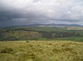
The Nant Rhuddnant gorge looking north to Cefn Coch from the summit of Pen y Garn. In the background are Y Garn (left), Pen Pumlumon Fawr and Pen Pumlumon Arwystli (right)
-
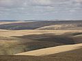
The Desert of Wales seen from Drygarn Fawr
-
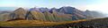
Panorama of some of the Snowdon Massif including Snowdon (centre right) taken from Mynydd Mawr. The Glyderau are visible in the distance
-
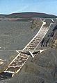
The Llyn Brianne spillway spilling immediately after its first fill at commissioning


See also
 In Spanish: Montes Cámbricos para niños
