Y Garn (Plynlimon) facts for kids
Quick facts for kids Y Garn |
|
|---|---|

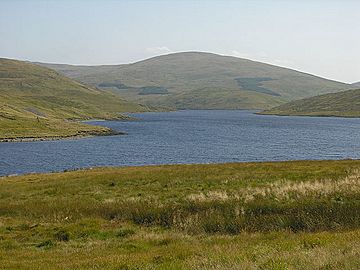
View over Nant-y-moch Reservoir
|
|
| Highest point | |
| Elevation | 684 m (2,244 ft) |
| Prominence | 56 m (184 ft) |
| Parent peak | Pen Pumlumon Fawr |
| Listing | Hewitt, Nuttall |
| Naming | |
| Language of name | Welsh |
| Geography | |
| Location | Ceredigion, Wales |
| Parent range | Cambrian Mountains |
| OS grid | SN789869 |
| Topo map | OS Landranger 135 |
Y Garn is a mountain peak in Wales. It is part of the larger Plynlimon mountain group, which is found in the Cambrian Mountains. Y Garn is the fourth highest peak in the Plynlimon area, located in the county of Ceredigion.
Discover Y Garn
Y Garn stands tall at 684 meters (about 2,244 feet) above sea level. It is considered a "subsidiary summit," which means it's a smaller peak connected to a bigger mountain, in this case, Pen Pumlumon Fawr.
Where is Y Garn?
This mountain is located in the beautiful Cambrian Mountains of central Wales. These mountains are known for their wild and open landscapes. Y Garn is specifically found in Ceredigion, a county on the west coast of Wales.
The Summit and Views
When you reach the top of Y Garn, you'll find a large stone structure called a cairn. This cairn is actually a shelter, but it was built from an ancient burial mound! From the summit, you can see amazing views all around.
You can look south towards other peaks like Rhos Fawr and Drygarn Fawr. To the north, you might spot mountains such as Aran Fawddwy. You can also see the Nant-y-moch Reservoir, a large body of water, sparkling below. Nearby, there are two smaller hills called Drosgol (550 meters) and Banc Llechwedd-mawr (560 meters). Both of these are known as Marilyns, which is a special term for hills in Britain and Ireland that rise at least 150 meters (about 492 feet) above the surrounding land.
 | Misty Copeland |
 | Raven Wilkinson |
 | Debra Austin |
 | Aesha Ash |

