Rhos Fawr facts for kids
Quick facts for kids Rhos Fawr |
|
|---|---|
| Great Rhos | |

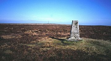
The summit plateau of Rhos Fawr
|
|
| Highest point | |
| Elevation | 660 m (2,170 ft) |
| Prominence | 379 m (1,243 ft) |
| Parent peak | Plynlimon |
| Listing | Marilyn, Hewitt, Nuttall, county top (Radnorshire) |
| Geography | |
| Location | Powys, Wales, historic county Radnorshire |
| Parent range | Cambrian Mountains |
| OS grid | SO182639 |
| Topo map | OS Landranger 148 |
Rhos Fawr, also known as Great Rhos, is a mountain in Mid Wales. It's the highest point in the Radnor Forest, which is a rather isolated group of hills. This mountain stands at 660 meters (about 2,165 feet) tall. It is also the highest point in the historic area of Radnorshire.
Where is Rhos Fawr?
Rhos Fawr is found in Powys, Wales. It's located north of the small village of New Radnor. The rocks that make up the mountain are mostly types of stone called shale and mudstone. There is also some older Silurian limestone.
The Summit and Surrounding Areas
The top of Rhos Fawr is a wide, flat area covered in heather. This flat top is called a plateau. To the east, another peak called Black Mixen is separated from Rhos Fawr by a valley known as Harvey Dingle.
Other mountains nearby include Drygarn Fawr and Gorllwyn to the west. To the northwest, you can find Plynlimon. North of Rhos Fawr are Beacon Hill and the Clun Forest in Shropshire. To the south, you can see the Black Mountains.
What is a Trig Point?
At the very top of Rhos Fawr, there is a clear trig point. A trig point is a special pillar that surveyors use to measure distances and heights. For people who enjoy walking or hiking, this trig point is a very helpful landmark. It helps them find their way on the wide and sometimes featureless summit plateau.
 | William L. Dawson |
 | W. E. B. Du Bois |
 | Harry Belafonte |

