
Mynydd Mawr facts for kids
Quick facts for kids Mynydd Mawr |
|
|---|---|

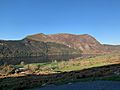
Mynydd Mawr from Trum y Ddysgl
|
|
| Highest point | |
| Elevation | 698 m (2,290 ft) |
| Prominence | 462 m (1,516 ft) |
| Parent peak | Moel Hebog |
| Listing | Marilyn, Hewitt, Nuttall |
| Naming | |
| English translation | big mountain |
| Language of name | Welsh |
| Geography | |
| Location | Gwynedd, Wales |
| Parent range | Snowdonia |
| OS grid | SH539546 |
| Topo map | OS Landranger 115 |
Mynydd Mawr is a mountain in Snowdonia, North Wales. Its name means big mountain in Welsh. It stands about 7 kilometers (4.3 miles) west of Snowdon.
This mountain overlooks Llyn Cwellyn lake. It is also the northern part of the Moel Hebog mountain group. Many people start their climb to Mynydd Mawr from a village called Rhyd Ddu.
On the western side of Mynydd Mawr, you can find old settlements and field systems. These show that people lived and farmed here a very long time ago.
If you look at Mynydd Mawr from the north, it often looks like an elephant lying down. Because of this, people sometimes call it "Yr Eliffant" (The Elephant) or "Elephant Mountain."
.jpg)
What You Can See From the Top
The top of Mynydd Mawr offers amazing views on a clear day. Looking west, you can see the Llŷn Peninsula and Caernarfon Bay. To the northwest, you might even spot Anglesey island.
If you look north, you will see Moel Eilio. To the east, you can spot Moel Hebog and the famous Snowdon mountain. On very clear days, you might even see the Wicklow Mountains in Ireland across the Irish Sea!
Images for kids
-
Mynydd Mawr with Cwellyn
-
Mynydd Mawr and the Glyderau
-
Mynydd Mawr frm Cwellyn


