
Llŷn Peninsula facts for kids
The Llŷn Peninsula (called Penrhyn Llŷn or Pen Llŷn in Welsh) stretches about 30 miles (50 km) into the Irish Sea. It is located in North West Wales, southwest of the Isle of Anglesey. This area is part of the historic county of Caernarfonshire and the region of Gwynedd.
A large part of the eastern peninsula, near Criccieth, is sometimes seen as part of Eifionydd. However, the exact border is not very clear. The Llŷn Peninsula covers about 150 square miles (400 km²) and has a population of at least 20,000 people.
Historically, the peninsula was a path for pilgrims traveling to Bardsey Island (Ynys Enlli in Welsh). Because it is a bit isolated, the Welsh language and culture have been well-preserved here. This makes the area famous for its strong Welsh identity.
Many people see Llŷn as a peaceful, unspoiled place. This has made it a popular spot for tourists and people who own holiday homes. However, holiday homes can be a problem for locals. Many find it hard to afford houses because prices are too high. In the past, a group called Meibion Glyndŵr protested against holiday homes.
A large part of the Llŷn Peninsula is a special place called an Area of Outstanding Natural Beauty. This covers about 62 square miles.
Contents
What's in a Name?
The name Llŷn is sometimes spelled Lleyn. However, this spelling is less common now. It is usually seen as an English way of writing the Welsh name. The name Llŷn is believed to come from an old Irish word, Laigin. This is the same root word as Leinster in Ireland. You can also find this word in Porthdinllaen on the north coast of the peninsula.
A Look Back in Time
After Owain Ddantgwyn (also known as Owain Whitetooth), a king of Gwynedd, passed away, his son Saint Einion is thought to have ruled Llŷn. He helped set up Saint Cadfan's monastery on Bardsey Island. This monastery became a very important place for pilgrimage in the Middle Ages.
There are many old wells across the peninsula. Many of these wells have holy meanings and were important stops for pilgrims.
The countryside here has many small houses, cottages, and farms. These look a bit like parts of southwest Ireland. There are also small, traditional villages. In the past, the main industries were quarrying and mining, but these have mostly stopped now.
The granite quarries in northern Llŷn left behind steep paths and docks. These quarries helped villages like Llithfaen and Trefor grow. People also mined for copper, zinc, and lead near Llanengan. From 1894 to 1945, a lot of manganese was mined at Y Rhiw. The Penrhyn Dû Mines near Abersoch have been mined since the 1600s.
Shipbuilding was also important in places like Nefyn, Aberdaron, Abersoch, and Llanaelhaearn. But this industry ended after steel ships became popular around 1880. Nefyn was also a big port for catching herring. Most coastal towns fished for crab and lobster.
Farming used to be very simple and natural. But after the Second World War, farming changed a lot. Machines became common. Land was drained, and fields were made bigger. From the 1950s, farmers started using a lot of artificial fertilizers and pesticides. This changed how the landscape looked.
Tourism grew after the railway to Pwllheli was built in 1867. Pwllheli quickly became bigger, with many large houses and hotels. A tramway was built to connect the town to Llanbedrog. After the Second World War, Butlins opened a holiday camp at Penychain. This brought many visitors from big cities in North West England and the West Midlands. As more people owned cars, tourism spread to the countryside and coastal villages. Many families in places like Aberdaron, Abersoch, Llanbedrog, and Nefyn earned extra money by renting out rooms or houses.
Pwllheli was the main administrative center of Llŷn for over 700 years. It was a royal town for the Kingdom of Gwynedd. After the English conquest, it became a free town. In the 1700s and 1800s, over 400 ships were built there.
Exploring Llŷn's Landscape
Llŷn is mostly a flat area with many volcanic hills and mountains. The biggest is Yr Eifl. Other notable hills include Garn Boduan, Garn Fadrun, and Mynydd Rhiw.
The northern coast has many steep cliffs and rugged rocks. There are also small islands and rock formations offshore. The southern coast has more sandy beaches, like Porth Neigwl and Castellmarch Beach. North of Abersoch, you can find sand dunes. The landscape is divided into many fields. Traditional stone walls, hedgerows, and earth banks (called cloddiau) are common features.
How the Land Was Formed
The rocks of Llŷn are very interesting. Most of the area is made of volcanic rocks from the Ordovician period. Rocks from the Cambrian period are found south of Abersoch. Many granite rocks and rhyolite outcrops form the prominent hills like Yr Eifl. Gabbro rock is found at the west end of Porth Neigwl.
The western part of the peninsula (northwest of a line from Nefyn to Aberdaron) is made of older Precambrian rocks. These are similar to the rocks found in Anglesey. Many faults (cracks in the Earth's crust) cross the area. A large shear zone (where rocks have moved past each other) runs through the western rocks. In 1984, there was an earthquake under the peninsula. It measured 5.4 on the Richter Scale and was felt in many parts of Ireland and western Britain.
During the ice ages, the area was covered by ice from the Irish Sea. This left behind boulder clay and channels formed by melting ice.
Special Places to Protect
Llŷn has many protected sites. These include a national nature reserve at Cors Geirch. It also has a National Heritage Coastline and a European Marine Special Area of Conservation. There are also 20 Sites of Special Scientific Interest.
The peninsula is home to a rare species of mason bee that is not found anywhere else. Much of the coast and hills are part of the Llŷn Area of Outstanding Natural Beauty. The Llŷn Coastal Path is a long distance footpath that lets people explore both sides of the peninsula on foot.
Lleyn Sheep

The Llŷn Peninsula is the original home of the Lleyn breed of sheep. This type of sheep is strong and has many lambs. It has become very popular in the last 20 years because it is good at having and raising lambs. Lleyn sheep have white faces. On average, female sheep (ewes) weigh about 70 kg, and male sheep (rams) weigh about 90 kg.
The Welsh Language
Until at least the 1960s, some people in the Llŷn Peninsula spoke only Welsh. Before 2001, the number of Welsh speakers in Gwynedd (which includes Llŷn) had gone down. However, the 2001 census showed that the number of Welsh speakers in Wales increased for the first time in over 100 years. About 20.5% of the population could speak Welsh. The 2001 Census also showed that 73.1% of people in Llŷn could speak Welsh.
By 2003, a survey of schools showed that over 94% of children aged 3 to 15 could speak Welsh. This makes Llŷn one of the main heartlands of the language. However, some people worry that many English speakers moving into the area might harm the future of Welsh as a living language. The Welsh Language and Heritage Centre of Nant Gwrtheyrn is located on the north coast.
Tân yn Llŷn (Fire in Llŷn) 1936
In 1936, people became very concerned about the Welsh language. This happened when the UK government decided to build a bombing school at Penyberth on the peninsula. The protests became known as Tân yn Llŷn (which means "Fire in Llŷn").
The government chose Llŷn after protests stopped them from building similar schools in other parts of the UK. However, the British Prime Minister, Stanley Baldwin, refused to listen to the Welsh people's concerns. A group representing half a million Welsh protesters tried to speak to him.
Saunders Lewis explained the protest by saying the government wanted to turn a place important for Welsh culture, language, and literature into a place for war training. On September 8, 1936, Saunders Lewis, Lewis Valentine, and D.J. Williams set the bombing school building on fire. They immediately turned themselves in to the police.
Their trial in Caernarfon could not decide on a verdict. So, the case was moved to the Old Bailey in London. The "Three" were sentenced to nine months in prison. When they were released, 15,000 people greeted them as heroes in Caernarfon.
Housing and Language
Some people believe that the rise in property prices in Llŷn has led to a decrease in Welsh speakers. Local Welsh speakers often cannot afford homes in the area. This is because house prices have gone up faster than average earnings in Wales. At the same time, many non-Welsh speakers are buying properties for retirement or as holiday homes.
This problem of locals being priced out of the housing market happens in many rural areas. But in Wales, it also affects the Welsh language. Many new residents do not learn Welsh.
How Llŷn is Governed
The entire Llŷn Peninsula is governed by Cyngor Gwynedd. This is a local government body that was set up in 1996. Before that, the area was part of Caernarfonshire.
Images for kids
-
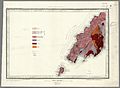
1850 Geological map of part of Llŷn
-
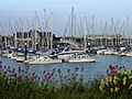
Pwllheli Marina
-
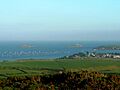
St. Tudwal's Islands from Mynytho
-
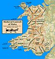
Map of Welsh cantrefi


See also
 In Spanish: Península de Lleyn para niños
