Yr Eifl facts for kids
Quick facts for kids Yr Eifl |
|
|---|---|

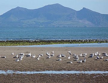
Yr Eifl from Ynys Llanddwyn
|
|
| Highest point | |
| Elevation | 561 m (1,841 ft) |
| Prominence | 429 m (1,407 ft) |
| Parent peak | Moel Hebog |
| Listing | Marilyn |
| Naming | |
| English translation | The forks. Also known as The Rivals as it sounds similar to 'yr Eifl' |
| Language of name | Welsh |
| Geography | |
| Location | Llŷn Peninsula, Wales |
| OS grid | SH364447 |
| Topo map | OS Landranger 123 |
Yr Eifl is a group of hills located on the north coast of the Llŷn Peninsula in Gwynedd, Wales. People sometimes call them "The Rivals" in English, as it sounds similar to their Welsh name.
When the weather is clear, you can see amazing views from the top! You might spot the Isle of Man, the Wicklow Mountains in Ireland, and even the Lake District. You can also see all of Cardigan Bay. Yr Eifl looks really cool from the southwest coast of Anglesey, especially from a place called Ynys Llanddwyn.
Official maps used to say Yr Eifl was 564 meters tall. However, a recent check shows its height is actually 561 meters (about 1,841 feet).
Contents
The Three Peaks of Yr Eifl
Yr Eifl is made up of three main peaks. Each one has its own special features:
- Tre'r Ceiri: This peak is about 485 metres (1,591 ft) high.
- Garn Ganol: This is the highest peak at 561 metres (1,841 ft).
- Garn Fôr: This peak is about 444 metres (1,457 ft) tall.
Garn Ganol: The Highest Point
Garn Ganol is the central and tallest peak of Yr Eifl. It is the highest point on the entire Llŷn Peninsula. At its top, you'll find an ancient pile of stones called a cairn. There is also a trig point here, which is a special marker used for surveying.
Garn Fôr: The Northern Peak
Garn Fôr is the northern peak, located across a pass called "Bwlch yr Eifl." This peak overlooks the sea. Garn Fôr is also known as Mynydd y Gwaith.
It has a microwave radio relay station on it, which helps send signals. You can also find more cairns and old granite quarries here. The granite from these quarries was even used for the curling event at the 2006 Winter Olympics! One side of Garn Fôr has a steep cliff that drops down to the Irish Sea.
Tre'r Ceiri: Home of Giants
The third peak, Tre'r Ceiri, is on the south-eastern side of Yr Eifl. This peak is famous for its Iron Age hillfort. A hillfort is an ancient settlement built on a hill for protection.
The name "Tre'r Ceiri" means "settlement of the giants." This comes from the Welsh word cewri, which is the plural of cawr (giant). This hillfort is considered one of the best examples of a prehistoric hillfort in all of Europe. There is a path that leads right up to its summit.
Exploring the Surroundings
You can reach Yr Eifl from several nearby villages. Paths lead onto the hill from Llithfaen to the south, Llanaelhaearn to the east, and Trefor to the north.
On the western slopes of Yr Eifl, below a cliff called Graig Ddu, there's a small valley that goes down to the sea. This valley is called Nant Gwrtheyrn ("Vortigern's Valley"). It's a special place with no public roads. It used to be a village for quarry workers, but now it's home to a center where people can learn the Welsh language.
Another granite quarry, known as Trefor quarry, can be found north of Garn Ganol.
 | Toni Morrison |
 | Barack Obama |
 | Martin Luther King Jr. |
 | Ralph Bunche |

