
River Wye facts for kids
Quick facts for kids River Wye |
|
|---|---|

The Wye at Hay-on-Wye
|
|
| Native name | Afon Gwy / River Wye |
| Country | Wales, England |
| Physical characteristics | |
| Main source | Plynlimon 690 m (2,260 ft) 52°28′5.170″N 3°45′56.282″W / 52.46810278°N 3.76563389°W |
| River mouth | Chepstow, Severn Estuary 0 m (0 ft) 51°36′36.086″N 2°39′42.423″W / 51.61002389°N 2.66178417°W |
| Length | 250 km (155 mi) |
| Basin features | |
| Basin size | 4,136 km2 (1,597 sq mi) |
| Tributaries |
|
.jpeg)
The River Wye (Welsh: Afon Gwy) is a very important river in the United Kingdom. It is the fourth-longest river in the UK. The Wye flows for about 250 kilometres (155 miles). It starts high up on Plynlimon mountain in mid Wales. The river ends in the Severn estuary.
For a lot of its journey, the River Wye forms part of the border between England and Wales. The lower part of the river, called the Wye Valley, is a special area. It is known as an Area of Outstanding Natural Beauty. The Wye is important for nature and for fun activities. However, it is currently facing big problems with pollution.
Contents
Where Does the Wye Flow?
The River Wye begins its journey in the Welsh mountains. Its source is on Plynlimon. From there, it flows through many towns and villages. These include Rhayader, Builth Wells, and Hay-on-Wye.
The Wye also passes through Hereford, which is the only city on the river. Other towns it flows by are Ross-on-Wye, Symonds Yat, Monmouth, and Tintern. Finally, it joins the Severn estuary near Chepstow. The last 16 miles (26 km) of the river, from Redbrook to Chepstow, marks the border between England and Wales.
Protecting the River Wye
| Site of Special Scientific Interest | |
| Grid reference | to |
|---|---|
| Interest | Biological/Geological |
| Area | England: 1,159.6 ha (2,865 acres) Wales: 245.2 ha (606 acres) Total: 1,404.8 ha (3,471 acres) |
| Notification | 1978 |
The River Wye is a very special place for nature. It is protected by two Sites of Special Scientific Interest (SSSIs). One SSSI covers the Upper Wye, which is the part of the river above Hay-on-Wye. The other SSSI covers the Lower Wye, which goes downstream to Chepstow.
These protections are in place because of the river's unique geology, landscape, plants, and animals. The Wye and its smaller rivers (tributaries) create a large natural home for many creatures. These include mammals, insects, fish, and birds. The Lower Wye SSSI is managed by different local councils. These include Powys, Herefordshire, Gloucestershire, and Monmouthshire.
The Wye is also a Special Area of Conservation. This means it is one of the most important rivers in the UK for protecting nature. It is a vital path for animals that migrate. It is also a key breeding area for many important species. These species are protected by European laws and UK laws. Much of the Wye Valley is also an Area of Outstanding Natural Beauty.
Salmon: A Special Fish
The Lower Wye is known as a great place for salmon fishing. The Wye used to be one of the best rivers for salmon fishing in the UK, outside of Scotland. In the 1980s and 1990s, the number of salmon in the Wye dropped a lot. For example, in 1988, over 6,400 salmon were caught by rod. By 2002, this number was only 357.
However, the salmon numbers are now getting better. This is thanks to hard work by the Wye and Usk Foundation. This group works to improve the river's habitat for salmon. By 2015, the average number of salmon caught over five years went above 1,000 again. The Wye is now the third-best salmon river in England and Wales.
The Wye was famous for its large "spring" salmon. These salmon would spend three or more years in the sea. Then they would return to the river to lay their eggs. They would enter the river between January and June. Some of these fish were very big, weighing over 50 pounds (23 kg). The biggest ever caught by rod was 59 lb 8 oz (27.0 kg) in 1923. Since the early 2000s, the number of spring salmon has been growing. Salmon weighing over 35 lb (16 kg) have been seen every year since 2011.
River Wye Pollution Concerns
Unfortunately, pollution has greatly affected the River Wye. The river does not meet the health standards set for rivers in Europe and the UK. Pollution from chicken and dairy farms has become a serious problem. The Wye has even been shown on TV shows like Countryfile to highlight river pollution in the UK.
Many people are worried about the river. One expert said that the Wye is changing very quickly. He noted that the riverbed, which used to be clean, is now very slimy. He also mentioned that in hot weather, the river can smell bad. This is due to waste from the millions of chickens raised in the area.
This pollution causes something called "algal blooms." These are times when tiny green plants (algae) grow too much in the water. This happens several times a year and is getting worse. When there are too many algae, they use up the oxygen in the water. This makes it hard for fish like brown trout, chubb, and barbel to breathe. It also harms water insects and plants. Fish and water insects are the main food for animals like otters, kingfishers, and herons.
The Wye is being polluted by manure from millions of chickens. These chickens are raised for eggs and meat on large farms. This waste gets into the Wye's smaller rivers, called tributaries. There are many of these large chicken farms in Powys and Herefordshire.
Also, runoff from dairy farms and farm waste (slurry) enters the Wye. A study found that many farm waste storage areas in Wales did not meet safety rules. Some farms were even spreading waste on fields before heavy rain. This caused more of it to wash into the rivers. Experts have warned that the rapid growth of the chicken farming industry is a big threat to nature in Wales.
History of the Wye

Long ago, the Romans built a bridge of wood and stone near what is now Chepstow. The River Wye has been used for boats up to Monmouth since at least the early 1300s. Later, in the 1660s, efforts were made to improve the river for boats up to Hereford. This involved building special gates called locks to help boats pass over obstacles.
Over time, these improvements were not enough. In 1696, a new law allowed for the removal of mills and other barriers on the Wye and its tributary, the River Lugg. This made the river easier to travel on for boats. By 1808, a path was added for horses to pull barges up to Hereford. Before this, people had to pull the boats themselves.
The Wye was used for commercial shipping until the 1850s. At that time, trains became a faster way to move goods. Today, the river is still used by boats, but mostly for fun.
Fun on the River Wye

The Environment Agency helps manage the river for boating. People can use canoes and kayaks on the river from Glasbury downstream. This is allowed as long as they do not disturb people who are fishing. The Wye is great for canoeing and kayaking because it has parts for all skill levels. You can paddle all the way from Hay to Hereford and Monmouth. You can even go to Chepstow and the Severn Estuary.
There are many places to rent canoes and go on guided trips. You can also find campsites along the river. Symonds Yat has a very popular section of rapids. These rapids were bought by the British Canoe Union in 2003 to make sure people could keep using them for fun.

There are three rowing clubs on the river. They are in Hereford, Ross-on-Wye, and Monmouth. These clubs hold yearly races for rowers of all skill levels. In 2017, over 600 people floated down the River Wye in inflatable boats during an event called WYE FLOAT.
If you like to walk, you can enjoy the Wye Valley Walk. This path follows the River Wye from its start near Plynlimon all the way to Chepstow. The path has clear signs to guide you. There is a special spot near The Biblins called 'Three Counties View'. This is where the counties of Herefordshire, Gloucestershire, and Monmouthshire meet.
Tributaries of the Wye
The River Wye has many smaller rivers and streams that flow into it. These are called tributaries. Some of the Wye's tributaries include:
- The river Lugg
- The Elan
- The Dulas
- The Irfon
- The Marteg
- The Monnow
- The Trothy
- The Ithon
- The Llynfi
- The Letton Lake
- The Tarennig (which is the Wye's very first tributary)
- The Bidno
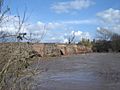
2020 Floods
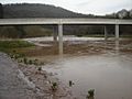
In February 2020, Wales and parts of England had very heavy rain. This was caused by Storm Dennis, which came soon after Storm Ciara. The middle part of South Wales was hit especially hard. The River Wye overflowed its banks. This caused flash flooding in several areas. These included Hay-on-Wye, Hereford, Ross-on-Wye, and Monmouth.
Much of Hereford was flooded, and homes were filled with water. Churches and community centers were opened to help people who had to leave their homes. In Monmouth, the river reached its highest level ever recorded.
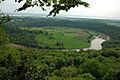
Views of the River Wye
-
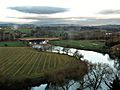
Ross-on-Wye, Herefordshire
-
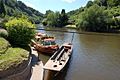
Water transport at Symonds Yat
-

Landscape with View on the River Wye by Thomas Jones
-
Eagle's Nest, Wyndcliff
-
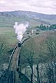
A steam-hauled stone train crossing the River Wye after departing from Tintern railway station in 1963


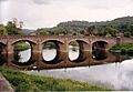
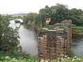
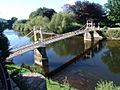
Bridges Over the River Wye
-

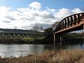
The old railway bridge at Redbrook
-
Monmouth Viaduct and Duke of Beaufort Bridge at Monmouth
-
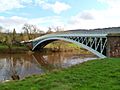
Bigsweir Bridge
-
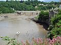
Chepstow Castle and bridge
-
Brockweir Bridge
-

Biblins Bridge
-
Wye Bridge, Monmouth
-
Wilton Bridge, Ross on Wye
-

Chepstow Bridge at very high tide
-
Backney Bridge, near Backney Halt, demolished under the Beeching Axe.
-
Victoria Bridge, Hereford
-
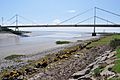
River Wye estuary and M48 Wye road bridge


See Also
 In Spanish: Río Wye para niños
