
M48 motorway facts for kids
Quick facts for kids
|
||||
|---|---|---|---|---|
| Lua error in Module:Infobox_road/map at line 15: attempt to index field 'wikibase' (a nil value). | ||||
_full_view_-_geograph.org.uk_-_1742850.jpg)
The Severn Bridge (M48)
|
||||
| Route information | ||||
| Maintained by Highways England and the South Wales Trunk Road Agency | ||||
| Length | 12 mi (19 km) | |||
| Existed | 1966–present | |||
| Major junctions | ||||
| East end | Awkley | |||
J21 → M4 motorway J23 → M4 motorway |
||||
| West end | Undy | |||
| Location | ||||
| Primary destinations: |
Chepstow | |||
| Road network | ||||
|
||||

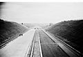
The M48 is a motorway in the United Kingdom. It's like a big, fast road that helps people travel between England and Wales. This motorway connects Gloucestershire in England with Monmouthshire in Wales. It's famous because it crosses the amazing Severn Bridge. The M48 is about 12 miles (19 kilometers) long.
About the M48 Motorway
The M48 is a special type of road called a motorway. Motorways are designed for fast and smooth travel over long distances. This road was opened in 1966. It was built to help connect different parts of the country.
Where the M48 Connects
Motorways have special exits called junctions. These junctions let drivers get on and off the motorway. The M48 has a few important connections:
- It connects to the M4 motorway at both its start and end points. The M4 is another very important motorway in the UK.
- One of its junctions, called J2, leads to Chepstow. Chepstow is a town in Wales.
- There are also services along the M48, like the Severn View services. These are places where drivers can stop for a break, food, or fuel.
Crossing the Bridges
A very important part of the M48 is how it crosses two big rivers. It uses two famous bridges:
- The Severn Bridge crosses the River Severn. This bridge connects England and Wales. When you drive over it, you move from one country to the other!
- The Wye Bridge crosses the River Wye. This bridge is also a key part of the M48 route.
For many years, drivers had to pay a toll to cross the Severn Bridge. This toll was removed on December 17, 2018. Now, it's free to drive across!
Images for kids
-
Construction near the hamlet of Ingst
-
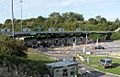
M48 toll booths toll-free since 17 December 2018


