Severn Estuary facts for kids

The Severn Estuary (which is Aber Hafren in Welsh) is a special place in Great Britain. It's where several rivers meet the sea. These rivers include the River Severn, the River Wye, the River Usk, and the River Avon. Many smaller rivers also join here. The water level here changes a lot between high and low tide. This big change, about 50 feet (15 meters), makes it a good spot for thinking about clean energy.
Contents
Where is the Severn Estuary?
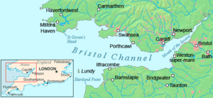
People have different ideas about where the Severn Estuary officially starts and ends. Some maps say it begins after the Second Severn Crossing. This is near Severn Beach in South Gloucestershire. It then stretches to a line between Lavernock Point (south of Cardiff) and Sand Point near Weston-super-Mare.
Other maps, like the Admiralty Chart, say the estuary goes further upstream. They say it reaches Aust, where the old Severn Bridge is. At Aust, the estuary is about 2 miles (3 km) wide. Between Cardiff and Weston-super-Mare, it gets much wider, about 9 miles (14 km) across.
The Border Between England and Wales
The Severn Estuary forms the natural border between Wales and England. On the Welsh side, to the north, you'll find the Caldicot and Wentloog Levels. These are flat lands around the city of Newport. Further west is the city of Cardiff and the seaside town of Penarth.
On the English side, to the south, there are towns like Avonmouth, Portishead, Clevedon, and Weston-super-Mare. There's also a tiny rocky island called Denny Island. It's about 0.24 acres (0.1 hectares) big. Even though its southern shore marks the border, the island itself is part of Monmouthshire, Wales.
Tides and Water Color
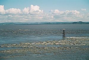
The estuary has one of the biggest tidal ranges in the world. This means the difference between high tide and low tide is huge, around 50 feet (15 meters). The estuary's shape, like a funnel, and the strong tides mix up the sand, gravel, and rock. This makes the water look very brown and muddy.
West of the line from Lavernock Point to Sand Point is the Bristol Channel. This channel then flows into the Celtic Sea and the huge Atlantic Ocean. Two islands, Steep Holm and Flat Holm, are located near this line in the middle of the estuary.
Sometimes, the term "Severn Estuary" also includes the part of the river that is affected by tides, all the way up to Gloucester. During the highest tides in this upper part, the rising water gets squeezed. This creates a special wave called the Severn bore. It's a single wave that travels quickly upstream against the river's flow.
Protecting the Severn Estuary's Wildlife
| Site of Special Scientific Interest | |
| Area of Search | Gloucestershire |
|---|---|
| Coordinates | 51°27′42″N 2°59′47″W / 51.4617°N 2.9965°W |
| Interest | Biological/Geological |
| Area | 15950 hectare |
| Notification | 1976 (Brean Down and Uphill Cliff 1952) |
| Site of Special Scientific Interest | |
| Area of Search | Gloucestershire |
|---|---|
| Interest | Biological/Geological |
| Area | 1436.8 hectare |
| Notification | 1954 |
|
Designations
|
|
| Official name: Severn Estuary | |
| Designated: | 5 January 1976 |
|---|---|
| Reference #: | 67 |
Because of its huge tides, the Severn Estuary has one of the largest areas of mudflats, sandflats, and rocky areas in the UK. These are called "intertidal habitats" because they are covered by water at high tide and exposed at low tide. These areas are home to many unique plants and animals. They are used to living in the extreme conditions of muddy water and strong tides.
The estuary is recognized as a very important wetland area worldwide. It's known as a Ramsar site. It's also a Special Protection Area (SPA) for wild birds and a Special Area of Conservation (SAC) for its habitats. These are all important ways to protect its nature.
Sites of Special Scientific Interest (SSSI)
Parts of the estuary are also called a Site of Special Scientific Interest (SSSI). This means they are protected because of their special wildlife or geology. The SSSI includes most of the muddy areas upstream from Cardiff and Brean Down. It also covers most of the upper estuary up to Sharpness. Another SSSI, the Upper Severn Estuary, covers the tidal river between Purton and Frampton on Severn.
The Severn Estuary SSSI is important for many reasons. It's especially vital for birds that spend the winter there or stop during their long journeys. It's the most important winter home for a bird called the dunlin. Many Bewick's swans, European white-fronted geese, and wigeon also live there in winter. Other important wintering birds include gadwall, shoveller, and pochard.
Seven different types of fish that migrate, like Atlantic salmon and common eel, also pass through the estuary. They travel in both directions, making it a key route for them.
Tidal Power Projects
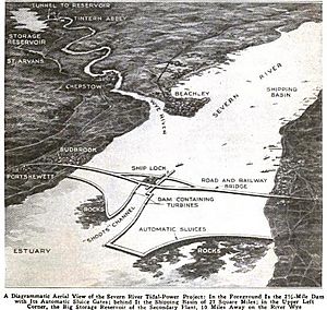
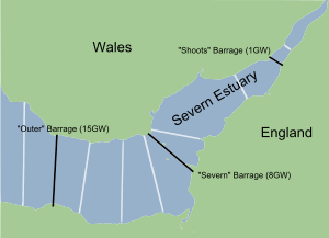
The Severn Estuary's huge tides and the nearby cities have made it a popular place to think about tidal energy. For many years, people have talked about building a Severn Barrage. This would be a wall about 16 miles (26 km) long across the Bristol Channel. It would stretch from Lavernock Point near Cardiff to Brean Down near Weston-super-Mare.
This barrage could create a lot of electricity, up to 8640 megawatts! It would work by trapping water in a huge lake, about 185 square miles (479 square kilometers) big. The water could be released to generate power when the tide flows. Tidal power only works for about ten hours a day. But by using the trapped water like a reservoir, it could generate power for more hours. This is similar to how pumped-storage power plants work, where water is pumped uphill when there's extra electricity and released to make power when needed.
Challenges and Future Plans
The UK Government stopped plans for a barrage in the late 1980s. This was mainly because it was very expensive and people worried about the environment. However, since then, energy prices have gone up a lot, and people are more concerned about global warming.
In 2006, the Welsh Assembly liked the idea of using tidal power. But the RSPB was very worried. They said it would harm the important mudflats, which are protected areas for birds. The UK government's energy review later that year did not support the plan.
People still have different opinions about whether a barrage is a good idea. In 2007, a new study called the Severn Tidal Power Feasibility Study was started. It looked at different ways to use the tides, like barrages and lagoons. This study helps the government decide if they should support such a big project.
The Severn Estuary could make more clean electricity than all other estuaries in the UK combined. It could provide up to 5% of the UK's electricity. This would help the UK reach its goals for fighting climate change and using renewable energy. However, some environmental groups are still against the idea of a large hydro-electric barrier because of its potential impact on the environment.
Severn Estuary Partnership
The Severn Estuary Partnership (SEP) started in 1995. It's an independent group that brings together local governments, official organizations, and people who use the estuary, like farmers and fishermen. Their main goal is to work together to manage the estuary. They want to make sure everyone's interests are considered.
In 2001, SEP published a "Strategy for the Severn Estuary." This plan helps guide how the estuary should be managed. SEP uses a wider definition of the Severn Estuary. They say it starts where the tide affects the River Severn in Gloucester. It ends at a line between Hurlestone Point near Minehead and Nash Point in the Vale of Glamorgan.
Archaeology in the Estuary
The Severn Estuary has a very rich and important history, shown by its archaeology. This is because the river has always been important for fishing and as a waterway for boats. However, these ancient sites are in danger. Natural forces like coastal erosion are a big threat, made worse by the strong tides. Also, new buildings, digging for sand and gravel, and new coastal defenses can harm these sites. There are also big projects planned that could affect them. You can find a report about the archaeology on the English side of the estuary online.
 | Emma Amos |
 | Edward Mitchell Bannister |
 | Larry D. Alexander |
 | Ernie Barnes |


