Denny Island facts for kids
 |
|
| Geography | |
|---|---|
| Location | Severn Estuary |
| Coordinates | 51°31′33″N 2°46′51″W / 51.52578°N 2.78091°W |
| Area | 2,400 m2 (26,000 sq ft) |
| Administration | |
|
Wales
|
|
| County Council | Monmouthshire |
| Demographics | |
| Population | 0 |
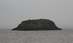
Denny Island, known as Ynys Denny in Welsh, is a small, rocky island. It's located in the Severn Estuary, which is where the River Severn meets the sea. This island is very tiny, only about 0.24 hectares (that's like half a football field!). No one lives on Denny Island.
The island's rocky southern shore forms a natural border. It marks the line between England and Wales. Even though it's a border, the island itself is part of Monmouthshire in South Wales. It also shows the edge of Bristol City's water area in the estuary.
Where is Denny Island?
Denny Island is found about three miles north of Portishead. It sits right in the middle of the water between Redwick in Wales and Avonmouth in England.
The island is surrounded by large areas of sand called sandbanks. These sandbanks are known as the Welsh Grounds. The amount of land you can see around the island changes a lot. This is because the tides in the Severn Estuary and Bristol Channel are some of the biggest in the world! The water level can rise and fall by as much as 13.7 meters (about 45 feet). This happens especially during the spring equinox.
Wildlife on the Island
Even though no people live on Denny Island, it's a busy place for birds! It's a popular spot for gulls, cormorants, and other seabirds to build their nests. Scientists often visit the island to study these birds. They sometimes put small rings on the birds' legs to track them. This helps them learn more about where the birds travel and how long they live.
A Glimpse into History
Denny Island first shows up in old records way back in 1373. It was called Dunye in a document that created the county of Bristol. Historians believe the name Dunye comes from an old English word. It likely means 'island shaped like a down'. A "down" is a type of rounded hill. So, the name probably describes the island's shape.
The island also gives its name to a geological feature. This is called the Denny Island Fault Zone. It's a part of a larger area of cracks in the Earth's crust. This larger area is known as the Avon-Solent Fracture zone.
 | Bayard Rustin |
 | Jeannette Carter |
 | Jeremiah A. Brown |

