
Portishead, Somerset facts for kids
Quick facts for kids Portishead |
|
|---|---|
|
From the top to bottom-right, Portishead Marina, The Seafront, Town Centre, Black Nore Lighthouse, St Nicholas' Church
|
|

Portishead
|
|
| Population | 26,366 (Parish, 2021) 26,355 (Built up area, 2021) |
| OS grid reference | ST470764 |
| Civil parish |
|
| Unitary authority | |
| Ceremonial county | |
| Region | |
| Country | England |
| Sovereign state | United Kingdom |
| Post town | BRISTOL |
| Postcode district | BS20 |
| Dialling code | 01275 |
| Police | Avon and Somerset |
| Fire | Avon |
| Ambulance | Great Western |
| EU Parliament | South West England |
| UK Parliament |
|


.jpg)
Portishead (pronounced PORT-iss-hed) is a lively town in Somerset, England. It's part of the North Somerset area. In 2021, about 26,366 people lived here. The town sits right on the Severn Estuary, facing Cardiff and Newport in Wales. It's about 8 miles (13 km) west of Bristol.
Portishead has a long history as a fishing port. It grew quickly in the 1800s around its docks. Later, a power station and chemical factories were built. Today, the old docks and factories are gone. They have been replaced by a modern marina and new homes. Portishead was also once home to "Portishead Radio." This was a special telephone centre used by British Telecom (BT) to connect calls to ships at sea. The main offices for the Avon and Somerset Constabulary (police) and Avon Fire and Rescue Service are in Portishead. The Portishead Lifeboat Station is also here. It's run by local volunteers from the Royal National Lifeboat Institution (RNLI). They help people in the Severn estuary and the waterways leading to Bristol.
Contents
- Exploring Portishead's Past
- How Portishead is Governed
- Portishead's Geography
- Portishead's Population
- Important Landmarks
- Getting Around Portishead
- Education in Portishead
- Places of Worship
- Sports and Activities
- Media in Portishead
- Culture and Arts
- Twin Towns
- Famous People from Portishead
- Images for kids
- See also
Exploring Portishead's Past
The name Portishead means "port at the head of the river." Over time, it has been called 'Portshead' and 'Portschute'. In the old Domesday Book, it was known as Portesheve. Locals sometimes called it Posset.
The town's story goes back to Roman times. There's also proof of people living here even before that, like old flint axe heads. People from the Iron Age also lived nearby. Cadbury Camp was the biggest settlement. Some believe Portishead was the western end of the Wansdyke. This was an old boundary with defensive earthworks.
After the Norman conquest, different powerful families owned the land. Eventually, the City of Bristol bought large parts of Portishead in 1621. They wanted access to the channel and a place to stay outside the city. In the 1800s, it became a popular seaside resort.
Portishead was built where a small stream met the Severn Estuary. An old jetty protected boats from the huge tides of the Bristol Channel. You can still see iron rings in the high street where fishing boats used to tie up. Because of its location, Portishead helped guard the "King Road," the waters around the headland. In 1497, John Cabot sailed from here on his ship, the Matthew. A fort was built at Battery Point. It was used during the English Civil War. Guns were also placed there during World War II.

In the 17th century, the City of Bristol bought land in Portishead. They built an outer sea wall. This helped drain the local marshes, creating more land for farming. Many buildings in Portishead are from the early Victorian era. The town grew a lot when the dock, pier, and railway to Bristol were built. The Royal Hotel, near the pier, was built in 1830. It offered a place to stay for people traveling by steamer from Bristol, Wales, and Ireland.
Portishead's Dock History
In the 1860s, during the time of iron and steel, a pier and a deep-water dock were built. This was done by the Bristol & Portishead Pier and Railway. It helped large ships that found it hard to reach Bristol Harbour. These ships brought valuable goods from all over the world. They also took local products overseas. Ships carrying coal were very common in Portishead Docks.
In the 1880s, the Port of Bristol took over Portishead Dock. It was managed as part of Bristol's port until it closed.
Portishead Power Stations

The Portishead power stations were large buildings that made electricity. They were built next to the dock and used coal for fuel. Work on Portishead "A" power station started in 1926. It began making electricity in 1929. A second power station, Portishead "B," started working in 1955.
These power stations used some local coal from the Somerset coalfield. This coal arrived by train on the Portishead branch line. But most of the coal came by boat from Newport and Ely in South Wales.
Railways in Portishead

Portishead had two passenger train stations on the GWR's Portishead branch line. One was near the town centre, and the other was at the pier. The original station was knocked down when the "B" power station was built. A new station opened in High Street in 1954. This new station closed in 1964.
Most of the railway line was reopened in 2002. It is now used to carry goods from the Royal Portbury Dock. There's a group working to reopen the station and the short part of the line that is still closed. In 2009, a report said that reopening the Portishead line was a good idea. This is because the area's population is growing, and there's more traffic.
Portishead also had another railway line for a short time. This was the Weston, Clevedon and Portishead Railway. It ran between Weston-super-Mare, Clevedon, and Portishead. This line opened to Portishead in 1907 but closed in 1940.
Albright and Wilson Chemical Works
In 1951, a company called Albright and Wilson built a chemical factory. It was on the other side of the dock from the power stations. This factory made white phosphorus from phosphate rock. The rock was brought in by ships through the docks. The power stations provided electricity for the factory's large furnaces. After the factory closed, a big clean-up was needed to remove dangerous chemicals. Today, the site is home to the Portishead volunteer coastguard.
Dock and Factory Closures
In the 1970s, newer, more efficient power stations were built elsewhere. This meant the older Portishead power stations were not needed as much. Portishead "A" power station closed in 1976. Its tall chimney stacks, which were a local landmark, were knocked down in the early 1980s. Portishead "B" power station closed in 1982. Its chimneys were demolished in 1992.
After the power stations closed, industrial work at the dock stopped. The Port of Bristol Authority finally closed the dock in 1992.
Modern Marina Development

Portishead's population has grown a lot because of the old docks being redeveloped. The deep-water dock, which once supplied coal to the power stations, is now a modern marina. It has 250 places for boats to dock.
The areas where the power stations and chemical plant used to be have been rebuilt. They now have many different types of homes, from townhouses to modern flats. New homes have also been built on the Portbury Ashlands area. This was once a dumping ground for power station waste.
This new waterfront area is called Port Marine. It has different styles of houses and apartments. One part looks like a fishing village from Cornwall, similar to Polperro, with narrow streets and colourful buildings. New bars and restaurants have opened around the marina, like Hall & Woodhouse and Costa Coffee.
A new RNLI lifeboat station opened at the top of the marina in 2015. It's run by about 40 local volunteers. There's also an RNLI shop there.
Portishead Radio Station
Portishead was once famous for "Portishead Radio." This was a special telephone centre run by British Telecom (BT). It handled calls to ships at sea that couldn't be dialled directly. Today, this service has mostly been replaced by satellite communications.
The radio station had separate places for sending and receiving signals. They were built by the Marconi Wireless Telegraph Company. By 1936, 60 radio officers worked there. They handled over 3 million words of radio messages each year.
The radio station was very important during World War II. It helped keep in touch with British merchant ships and patrol planes in the North Atlantic. During the war, messages to ships were only one-way. This was to prevent the enemy from finding the ships' locations.
By the late 1980s, satellite communication became more popular. This meant less business for Portishead Radio. The station began to close down parts of its operations. The long-range services stopped in August 1999. The short-range services closed in April 2000. The station fully closed in June 2000. The Highbridge station, where the receiving equipment was, has since been knocked down. New houses have been built on that site.
How Portishead is Governed
Portishead has two levels of local government. These are the Portishead Town Council and the North Somerset Council. The Town Council is based at the Folk Hall on High Street.

The police force for the area is the Avon and Somerset Constabulary. The Avon Fire and Rescue Service has a fire station in Portishead. It's staffed by firefighters who are on call. The South Western Ambulance Service provides ambulance services.
Portishead used to be an old parish. Over time, its local government changed. In 1974, it became part of the Woodspring district. Later, Woodspring became the unitary authority of North Somerset in 1996. The parish name changed a few times, but in 2011, it went back to just Portishead.
Political Representation
The town is part of the North Somerset area for the UK Parliament. Since 1992, it has been represented by Liam Fox from the Conservative Party.
Portishead's Geography
Natural Features

Portishead is a coastal town on the Severn Estuary. It's north-east of Clevedon and south-west of Avonmouth. The River Avon forms the border between Somerset and Bristol. Bristol city is about 6 miles (10 km) to the east. On clear days, you can see Wales across the Severn Estuary.
The Eastwood area is a special local nature reserve. It has broadleaf woodland on a coastal limestone ridge. This leads to Battery Point, which once had defensive guns. The Portishead Point Lighthouse is also on this headland. The area is also interesting for its fossils, folds, and faults in the rocks.
Just inland from Portishead is the Gordano Valley. This area is a national nature reserve. The valley runs between limestone ridges. The M5 motorway runs along the south side of the valley. Much of the valley is reclaimed land, meaning it's barely above sea level. It's drained by ditches called "rhynes." The name Gordano comes from Old English. It means "muddy valley," describing the valley's shape.
Denny Island is a small, rocky island about three miles north of Portishead. It's only about 0.6 acres (0.24 hectares). The southern shore of the island marks the border between England and Wales. However, the island itself is part of Monmouthshire, Wales. The tides in the Severn Estuary and Bristol Channel are very large. They can rise and fall by as much as 49 feet (15 metres). This is the second largest tidal range in the world, after the Bay of Fundy in Eastern Canada.
Portishead Pier to Black Nore SSSI is a special geological Site of Special Scientific Interest. It covers about 177 acres (72 hectares). This area shows important rock formations from the Carboniferous Period. It also has Devonian rocks with several types of fossil fish.

The Lake Grounds area was built in the early 1900s around an artificial lake. It's the town's main park. Next to the beach and promenade, there's a 100-year-old artificial lake. There's also a cricket pitch with grassy areas and trees. One of the UK's few remaining outdoor swimming pools is on the shore next to the lake grounds. It's open in the summer. In 2009, the outdoor pool was renovated by a TV show. Above the lake grounds is Battery Point. This is where a gun battery was placed to protect the Severn Estuary.
Portishead's Climate
Like the rest of South West England, Portishead has a mild climate. It's generally wetter and milder than other parts of England. The average yearly temperature is about 10 °C (50 °F). January is the coldest month, and July and August are the warmest. December is usually the cloudiest month, and June is the sunniest. The area gets about 1,600 hours of sunshine each year.
Rainfall often comes from Atlantic depressions. In summer, showers and thunderstorms are common. The average rainfall is around 800–900 mm (31–35 in). Snowfall is typical for about 8–15 days a year. Winds are strongest from November to March and lightest from June to August. The wind usually comes from the south-west.
Portishead's Population
In 2016, Portishead had a population of 22,000. This was a big increase from 17,130 in 2001. The town's population grew by 40 percent, much faster than nearby towns. Because many new homes are being built, another 8,000 people are expected to move to Portishead by 2026. This will make Portishead one of the largest towns in North Somerset.
Important Landmarks

Court House Farmhouse is a very old building. It dates back to the medieval period. It was changed in the 1600s and 1800s. It's a Grade II* listed building, meaning it's very important.
The red brick National Nautical School was built in 1905. It cost £30,000. This school used to be on a training ship. It operated until 1983. Now, it's part of a private community called Fedden Village.
The remains of an old windmill, built in 1832, were later turned into a house. In 1908, it became part of a golf club house. Today, the building is a pub. There's also a small, old, black village pump in Portishead.
The 9-metre (30 ft) high Portishead Point Lighthouse was built at Battery Point in 1931. The Bristol Port Company maintains it. Black Nore Lighthouse was built in 1894. It was made electric during World War II. In 2011, it was sold to a trust to be preserved.
The Royal Hotel was designed for Brunel's railway line. It was built in 1830 by the Corporation of Bristol. It was meant to be a hotel for the growing seaside resort. It's a Grade II listed building. The Royal Hotel closed in late 2022 for upgrades. It is planned to reopen as a hotel in summer 2023.
Getting Around Portishead
.JPG)
Many residents want the Portishead to Bristol railway line to reopen. The estimated cost is £28 million. Plans are being considered to make this happen.
The main A369 road links the town to the nearby M5 motorway. This road can get very busy, especially during rush hours. Changes to traffic flow have caused some debate. Many people feel they made traffic worse. Over 4,000 residents signed a petition about their concerns.
In September 2009, a trial was done to turn off traffic lights in Portishead. This made journey times much shorter, sometimes by over 50%. It also didn't make it less safe for people walking. The change was made permanent.
Portishead has bus routes, including a bus to Bristol every half hour. There are also local buses to Nailsea and Weston-super-Mare. The WESTlink on-demand bus also serves the town.
A lifeboat service has been in Portishead since 1996. In 2015, it moved to a new RNLI lifeboat station next to the pier.
Education in Portishead
The Unitary Authority of North Somerset supports 78 schools. These schools teach about 28,000 students. In Portishead, there are several infant and primary schools. These include High Down Infant and Junior, Portishead Primary, St. Joseph's Catholic Primary, St. Peter's C of E Primary, and Trinity Anglican Methodist Primary School.
For older students, Gordano School provides secondary education. It enrolls over 2000 students aged 11–19. The school officially opened in 1957. It cost £146,000 to build. By September 1957, there were 500 students. In 1975, more money was given for new buildings. Gordano was called the "Big Experiment" because it was Somerset's first comprehensive school. It had 900 students and 30 teachers.
In 1994, an astroturf sports field was added for £260,000. By then, the school had 1,589 students and 88 teachers. In 2009, Gordano School became an academy. Many new buildings have been added since then. These include a new sixth-form centre, an English block, a new maths building, and extensions to other departments. Most recently, a new sports hall with a gym and indoor sports facilities opened.
Since 2016, several schools in Portishead have joined together. High Down Infant and Junior Schools, Gordano School, Portishead Primary School, and St. Peter's C of E Primary School formed a group called The Lighthouse Partnership. Trinity Anglican Methodist School is part of a different group called the Bath & Wells Multi Academy Trust.
Places of Worship

The Norman Church of St Peter was built in 1320. It was rebuilt in the 1300s and 1400s in the Perpendicular Gothic style. In 1952, it became a Grade I listed building. Its four-stage tower is a well-known landmark. The church was changed in 1978–1979. It also has a new garden created for the Millennium.
The Chapel of Portishead National Nautical School (now The Fedden Village) on Nore Road dates back to 1911. It is dedicated to St. Nicholas and is also a listed building.
There is also a busy URC church. It opened on March 6, 1840. One of its early supporters was Henry Overton Wills, from the famous Wills tobacco family. They were strong Congregationalists.
Sports and Activities
Portishead has a sports and leisure complex. Part of its funding came from the National Lottery. It has a large swimming pool, fun pools, indoor bowls, six badminton courts, a gym, a play room for toddlers, a cafe, and a licensed bar.
Other sports facilities in town include outdoor tennis courts. There's also a large outdoor swimming pool, which opened in 1962 and was renovated in 2009. You can find a boating lake, cricket ground, football and hockey pitches. There are also many cycle lanes. The cricket club has been around since the 1800s.
Portishead Town F.C. is the local football club. They played in smaller leagues for years. In 1975, they joined the Somerset County Football League. They won the Premier Division title four times in five years during the 1990s. In 2005, Portishead moved up to the Western Football League. In the 2006–07 season, they had their best finish ever, coming in second place.
Media in Portishead
Regional TV news for Portishead comes from BBC West and ITV West Country. Television signals are received from the Mendip and local relay transmitters.
Local radio stations include BBC Radio Bristol (94.9 FM), Heart West (96.3 FM), Greatest Hits Radio South West (107.2 FM), and Hits Radio Bristol & The South West (106.5 FM).
The North Somerset Times (formerly the Portishead Times) is the town's local weekly newspaper.
Culture and Arts

The trip hop music group Portishead, based in Bristol, took their name from the town. They even called it their "dreary home-town." Chaos UK is a punk band that started in Portishead in 1979. The town was also the birthplace of Adge Cutler, a famous "Scrumpy and Western" singer.
There are many groups and societies in Portishead. The Gordano society focuses on history, conservation, and wildlife. There's also a horticultural society and the Portishead Railway Group. This group is working to reopen the railway line to Bristol. Other groups include the Portishead Youth Club and a choral society, which started in 1955. The town also has an annual carnival.

A public art project began in 1999 as part of the marina development. An art trail features 28 public artworks around the marina and Ashlands development.
Twin Towns
In 1989, Portishead became twinned with Den Dungen. This is a small town of about 6,000 people in the Netherlands. It's about 3 miles (5 km) from the city of 's-Hertogenbosch.
In 1992, Portishead also twinned with Schweich. This is a town of about 20,000 people in Germany. It's about 6 miles (10 km) from the Roman city of Trier. Schweich is located on the Moselle.
Famous People from Portishead
- Johnny Briggs, an actor
- George Wightwick, an architect
- Adge Cutler, a popular singer
- Eddie Large, a comedian
- Carol Vorderman, a TV presenter
- Chris Harris, a pantomime performer, director, and writer
- Frederic Weatherly, who wrote the lyrics for "Danny Boy"
- Imogen Cairns, an Olympic gymnast
- Geoff Barrow, a member of the band Portishead
- Admiral Sir Tony Radakin, a Naval Officer and current Chief of the Defence Staff
Images for kids
-
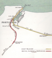
Railway map from 1914
See also
 In Spanish: Portishead (Somerset) para niños
